Schuylkill Canal Association

Last updated
Lock 60 gates and bridge after their 2004-5 restoration. Lock60 20070421.jpg
Lock 60 gates and bridge after their 2004-5 restoration.

The Schuylkill Canal Association (SCA) is a non-governmental organization that maintains the Oakes Reach and Lock #60 of the Schuylkill Canal as a public recreation area and historical site. Organized in 1982 as the Schuylkill Canal Advisory Board, the Association, in cooperation with Upper Providence Township, Montgomery County, and the Commonwealth of Pennsylvania, maintains the canal reach, associated structures, parks and trails. The area extends along the canal and left bank of the Schuylkill River, from Mont Clare past Port Providence. The area makes up a large part of the Schuylkill Navigation Canal, Oakes Reach Section Historic District (#88000462).

Non-governmental organization organization that is neither a part of a government nor a conventional for-profit business

Non-governmental organizations, nongovernmental organizations, or nongovernment organizations, commonly referred to as NGOs, are usually non-profit and sometimes international organizations independent of governments and international governmental organizations that are active in humanitarian, educational, health care, public policy, social, human rights, environmental, and other areas to affect changes according to their objectives. They are thus a subgroup of all organizations founded by citizens, which include clubs and other associations that provide services, benefits, and premises only to members. Sometimes the term is used as a synonym of "civil society organization" to refer to any association founded by citizens, but this is not how the term is normally used in the media or everyday language, as recorded by major dictionaries. The explanation of the term by NGO.org is ambivalent. It first says an NGO is any non-profit, voluntary citizens' group which is organized on a local, national or international level, but then goes on to restrict the meaning in the sense used by most English speakers and the media: Task-oriented and driven by people with a common interest, NGOs perform a variety of service and humanitarian functions, bring citizen concerns to Governments, advocate and monitor policies and encourage political participation through provision of information.

Schuylkill Canal

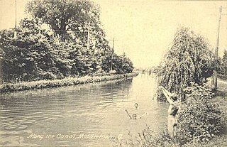
Schuylkill Canal is the common, but technically inaccurate, name for the Schuylkill Navigation, a 19th-century commercial waterway in and along the Schuylkill River in the U.S. state of Pennsylvania. The "canal" was actually a system of interconnected canals and slack-water pools in the river, which is called a navigation. Chartered in 1815, the Schuylkill Navigation opened in 1825 to provide transportation and water power. At the time, the river was the least expensive and most efficient method of transporting bulk cargo, and the eastern seaboard cities of the U.S. were experiencing an energy crisis due to deforestation. It fostered the mining of anthracite coal as the major source of industry between Pottsville and eastern markets. Along the tow-paths, mules pulled barges of coal from Port Carbon through the water gaps to Pottsville; locally to the port and markets of Philadelphia; and some then by ship or through additional New Jersey waterways, to New York City markets.

Upper Providence Township, Montgomery County, Pennsylvania Township in Pennsylvania, United States

Upper Providence Township is a township in Montgomery County, Pennsylvania, United States. As of the 2010 census, the township population was 21,219.

Contents

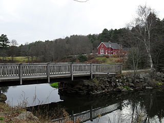
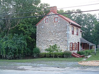
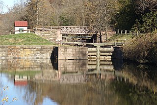
As its first priority project, SCA repaired the Lock 60 lock tender's house at Lock 60 that had been abandoned in the 1950s. The lock tender's house was eventually restored to habitable condition. The restoration of Lock 60 itself to operating condition was another major SCA project that was completed in 2005. The house and lock are both contributing structures to the historic district.

Contributing property key component of a place listed on the National Register of Historic Places

In the law regulating historic districts in the United States, a contributing property or contributing resource is any building, object, or structure which adds to the historical integrity or architectural qualities that make the historic district, listed locally or federally, significant. Government agencies, at the state, national, and local level in the United States, have differing definitions of what constitutes a contributing property but there are common characteristics. Local laws often regulate the changes that can be made to contributing structures within designated historic districts. The first local ordinances dealing with the alteration of buildings within historic districts was in Charleston, South Carolina in 1931.

SCA maintains the area near Lock 60 as a public park and periodically opens the lock tender's house and operates the lock for small recreational craft. The Canal Park has a river launch area and a floating dock in the canal. An association maintained portage trail at the other end of the canal reach, which with the park, creates a 5-mile (8.0 km) canoe and kayak loop. SCA also maintains the towpath trail and other adjacent trails. Plans to route the Schuylkill River Trail along the canal towpath will likely shift towpath maintenance from SCA to the county.

Portage carrying water craft or cargo over land

Portage or portaging is the practice of carrying water craft or cargo over land, either around an obstacle in a river, or between two bodies of water. A path where items are regularly carried between bodies of water is also called a portage.

Canoe light boat that is paddled

A canoe is a lightweight narrow vessel, typically pointed at both ends and open on top, propelled by one or more seated or kneeling paddlers facing the direction of travel using a single-bladed paddle.

Kayak small boat propelled with a double-bladed paddle

A kayak is a small, narrow watercraft which is typically propelled by means of a double-bladed paddle. The word kayak originates from the Greenlandic word qajaq.

Canal Day

Restored Lock Tender's House open for Canal Day 2008 Lock Tender's House 2008-06-29.jpg
Restored Lock Tender's House open for Canal Day 2008

The SCA organizes the annual Canal Day each summer on the last Sunday in June. This summer fair features events centered around the canal, including: a canoe and kayak race, a run, opening of the lock, and the popular pugil stick joust on a telephone pole over the canal. The events take place at the Lock 60 Canal Park and adjacent St. Michael's recreation field in Mont Clare.

Pugil stick

A pugil stick is a heavily padded pole-like training weapon used since the early 1940s by military personnel in training for rifle and bayonet combat. The pugil stick is similar to a quarterstaff or Japanese bo, and may be marked to indicate which end represents the bayonet and which the rifle butt. Dr. Armond H. Seidler (1919-2017) of the University of New Mexico invented the Pugil Stick training method during World War II. It was initially adopted by the United States Marine Corps, but was later included in United States Army combat training as well. Dr. Seidler received an award from the Marine Corps for his invention.

Internet presence

The Association is one of the earliest organizations on the Internet, where its presence as canal.org dates back to at least 1989. [1]

Internet Global system of connected computer networks

The Internet is the global system of interconnected computer networks that use the Internet protocol suite (TCP/IP) to link devices worldwide. It is a network of networks that consists of private, public, academic, business, and government networks of local to global scope, linked by a broad array of electronic, wireless, and optical networking technologies. The Internet carries a vast range of information resources and services, such as the inter-linked hypertext documents and applications of the World Wide Web (WWW), electronic mail, telephony, and file sharing.

Related Research Articles

Illinois and Michigan Canal canal

The Illinois and Michigan Canal connected the Great Lakes to the Mississippi River and the Gulf of Mexico. In Illinois, it ran 96 miles (154 km) from the Chicago River in Bridgeport, Chicago to the Illinois River at LaSalle-Peru. The canal crossed the Chicago Portage, and helped establish Chicago as the transportation hub of the United States, before the railroad era. It was opened in 1848. Its function was largely replaced by the wider and shorter Chicago Sanitary and Ship Canal in 1900, and it ceased transportation operations with the completion of the Illinois Waterway in 1933.

Wabash and Erie Canal

The Wabash and Erie Canal was a shipping canal that linked the Great Lakes to the Ohio River via an artificial waterway. The canal provided traders with access from the Great Lakes all the way to the Gulf of Mexico. Over 460 miles long, it was the longest canal ever built in North America.

Cuyahoga Valley National Park national park of the United States

Cuyahoga Valley National Park is an American national park that preserves and reclaims the rural landscape along the Cuyahoga River between Akron and Cleveland in Northeast Ohio. Cuyahoga Valley is unusual among American national parks being adjacent to two large urban areas and including a dense road network, small towns, and private attractions.

Swatara Creek is a 72-mile-long (116 km) tributary of the Susquehanna River in east central Pennsylvania in the United States. It rises in the Appalachian Mountains in central Schuylkill County and passes through northwest Lebanon Valley before draining into the Susquehanna at Middletown.

Union Canal (Pennsylvania)

The Union Canal was a towpath canal that existed in southeastern Pennsylvania in the United States during the 19th century. First proposed in 1690 to connect Philadelphia with the Susquehanna River, it ran approximately 82 mi from Middletown on the Susquehanna below Harrisburg to Reading on the Schuylkill River.

Miami and Erie Canal canal

The Miami and Erie Canal was a 274-mile (441 km) canal that ran from Cincinnati to Toledo, Ohio, creating a water route between the Ohio River and Lake Erie. Construction on the canal began in 1825 and was completed in 1845 at a cost to the state government of $8,062,680.07. At its peak, it included 19 aqueducts, three guard locks, 103 canal locks, multiple feeder canals, and a few man-made water reservoirs. The canal climbed 395 feet (120 m) above Lake Erie and 513 feet (156 m) above the Ohio River to reach a topographical peak called the Loramie Summit, which extended 19 miles (31 km) between New Bremen, Ohio to lock 1-S in Lockington, north of Piqua, Ohio. Boats up to 80 feet long were towed along the canal by mules, horses, or oxen walking on a prepared towpath along the bank, at a rate of four to five miles per hour.

Chesapeake and Ohio Canal National Historical Park National Historical Park located in the District of Columbia and the states of Maryland and West Virginia

The Chesapeake and Ohio Canal National Historical Park is located in the District of Columbia and the states of Maryland and West Virginia. The park was established in 1961 as a National Monument by President Dwight D. Eisenhower to preserve the neglected remains of the Chesapeake and Ohio Canal and many of its original structures. The canal and towpath trail extends along the Potomac River from Georgetown, Washington, D.C., to Cumberland, Maryland, a distance of 184.5 miles (296.9 km). In 2013, the path was designated as the first section of U.S. Bicycle Route 50.

Oaks, Pennsylvania Unincorporated community in Pennsylvania, United States

Oaks is an unincorporated community located in Upper Providence Township, Montgomery County, Pennsylvania, 18 miles (30 km) northwest of Philadelphia. Its boundaries are defined in large part by the village's position at the junction of Perkiomen Creek and the Schuylkill River.

Old Erie Canal State Historic Park

The Old Erie Canal State Historic Park encompasses a 36-mile (58 km) linear segment of the original Erie Canal's Long Level section. It extends westward from Butternut Creek in the town of DeWitt, just east of Syracuse, to the outskirts of Rome, New York. The park includes restored segments of the canal's waterway and towpath which were in active use between 1825 and 1917. It is part of the New York State Park system.

Pennsylvania Canal (Delaware Division) canal in eastern Pennsylvania

The Delaware Division of the Pennsylvania Canal, more commonly called the Delaware Canal, runs for 60 miles (97 km) parallel to the right bank of the Delaware River from the entry locks near the mouth of the Lehigh River and terminal end of the Lehigh Canal at Easton south to Bristol. At Easton, which today is the home of The National Canal Museum, the Delaware Canal also connected with the Morris Canal built to carry anthracite coal to energy starved New Jersey industries. Later, with a crossing-lock constructed at New Hope, the New Hope 'outlet lock' (1847) connected by Cable Ferry to a feeder navigation/canal at Bull's Island along the opposite shore from Lumberville, which ran over 22 miles (35 km) south along the left bank through Trenton to Bordentown, the west end of the Delaware and Raritan Canal (1834) to New York City via New Brunswick. as part of the solution to the United States' first energy crisis. The Commonwealth of Pennsylvania built the Delaware canal to feed anthracite stone coal to energy-hungry Philadelphia as part of its transportation infrastructure building plan known as the Main Line of Public Works—a legislative initiative creating a collection of self-reinforcing internal improvements to commercial transportation capabilities.

Schuylkill River Trail

The Schuylkill River Trail is a multi-use trail along the banks of the Schuylkill River in southeastern Pennsylvania. Partially complete as of 2018, the trail is ultimately planned to run about 140 miles (230 km) from the river's headwaters in Schuylkill County to Fort Mifflin in Philadelphia.

Mont Clare, Pennsylvania Village in Pennsylvania, United States of America

Mont Clare is a village in Upper Providence Township, Montgomery County, Pennsylvania, United States. The village is located on the left bank of the Schuylkill River, opposite Phoenixville and Chester County. Mont Clare is at the site of the former Jacobs' ford. Mont Clare hosts the only functional lock and one of only two remaining watered stretches of the Schuylkill Canal. Mont Clare was the birthplace of the infamous outlaw Sundance Kid.

Lehigh Canal

The Lehigh Canal or the Lehigh Navigation Canal is a navigable canal, beginning at the mouth of Nesquehoning Creek on the Lehigh River in Eastern Pennsylvania. It was built in two sections over a span of twenty years, beginning in 1818. The lower section spanned the distance between Easton, Pennsylvania and the town of Mauch Chunk, present-day Jim Thorpe, Pennsylvania. In Easton the canal met the Delaware and Morris Canals, with which goods could be brought further up the east coast. At its height, the Lehigh Canal was 72 miles (116 km) long.

Lea Valley Walk

The Lea Valley Walk is a 50-mile (80 km) long-distance path located between Leagrave, the source of the River Lea near Luton, and the Thames, at Limehouse Basin, Limehouse, east London. From its source much of the walk is rural. At Hertford the path follows the towpath of the River Lee Navigation, and it becomes increasingly urbanised as it approaches London. The walk was opened in 1993 and is waymarked throughout using a swan logo.

Blackstone River and Canal Heritage State Park

The Blackstone River and Canal Heritage State Park is a part of the state park system of the Commonwealth of Massachusetts, managed by the Massachusetts Department of Conservation and Recreation (DCR). This 1,000-acre (4.0 km2) park "recalls the role of canals in transporting raw materials and manufactured goods between emerging industrial centers." The Blackstone River and Canal Heritage State Park at Uxbridge, Massachusetts, is the midpoint of the Blackstone River Valley National Heritage Corridor of the National Park System. The Blackstone River and Valley is where the industrial revolution was born in America. The southern entrance to this state park is the site of the historic Stanley Woolen Mill, currently being redeveloped for commercial and tourism. The Native American Nipmuc name for the village here was "Wacentug", translated as "bend in the river".

Leesport Lock House

The Leesport Lock House is a house accompanying a lock on the Schuylkill Canal in Leesport, Pennsylvania, USA. The house was built adjacent to the Leesport Locks #36 and #37 to allow canal barges to move quickly up and down the canal. The house was listed on the National Register of Historic Places on June 9, 1977. The property was purchased in 1975 by a group of teachers and school directors from the Schuylkill Valley School District. They organized the Leesport Lockhouse Foundation. After paying the no interest mortgage, provided by The First National Bank of Leesport, they turned title to the property over to Berks County. The County purchased the neighboring car wash, built over a section of the locks, and transferred ownership to the Borough of Leesport. The property and programs are administered by the Leesport Lockhouse Foundation, Inc.

Black Rock Dam (Schuylkill River)

The Black Rock Dam is a low head dam in the Schuylkill River. Originally constructed as a stone filled, timber crib dam in the early 19th century by the Schuylkill Navigation Company, the dam was one of dozens built to create a slack water pools for the Schuylkill Navigation System. The dam is a contributing property of the "Schuylkill Navigation Canal, Oakes Reach Section" registered historic district. The dam is located between Phoenixville and Mont Clare in southeastern Pennsylvania, USA.

Manayunk Canal Towpath

The Manayunk Canal Towpath is a trail that runs along the Schuylkill River Canal in Manayunk, Pennsylvania, a northwest section of Philadelphia. The Towpath parallels the Manayunk Canal and the Schuylkill River. The Towpath is accessible from Fairmount Park to the East and from the Schuylkill River Trail to the West. As the Towpath runs through heavy industry and rural-like settings, its surface varies between boardwalk, gravel, and pavement. This makes the Towpath ideal for running, walking, and cycling. Fishing in the Schuylkill Canal along the Manayunk Towpath is a favorite past time for visitors and residents alike. Visible along the Towpath are rail lines, old canal locks, ruins of the lock tender's house and old textile mills. Plentiful wildlife thrives along the Manayunk Canal Towpath including many species of birds, fish, turtles, and native plants. The Manayunk Development Corporation is currently organizing a full restoration of the Manayunk Canal; once the restoration is complete, it will be possible for canoes and small boats to sail through the Manayunk Canal Towpath as they make their way down the Schuylkill River.

References

  1. "canal.org whois data" . Retrieved January 17, 2010.