Marlborough is a city in Middlesex County, Massachusetts, United States. The population was 41,793 at the 2020 census.[4] Marlborough became a prosperous industrial town in the 19th century and made the transition to high technology industry in the late 20th century after the construction of the Massachusetts Turnpike. It is part of the Worcester metropolitan area.
In 1656, several families from Sudbury, Massachusetts, led by Edmund Rice, John Howe, John Ruddock, and John Bent, petitioned the Massachusetts General Court to create a new town. The proposed town would be located southwest of Sudbury at the intersection of two trails used by local Native American tribes, known as the Nashua Trail and Connecticut path. Its name would be Marlborough, after the market town in Wiltshire, England of the same name.[5]
The land belonged to a tribe of Pennacook Native Americans whose population had been decimated by the introduction of European diseases a few decades prior. In 1656, only 50 or so Pennacooks remained in the area. The Pennacook people spoke an Algonquian language; this was among the reasons that Howe, a fur trader who spoke Algonquian, became the first settler to move to the area. The Pennacook, knowing their reduced numbers left them vulnerable to attacks from other Native groups, initially welcomed the settlers in exchange for their assistance protecting the tribe.[5]
Marlborough was officially incorporated as a town in 1660. Rice, a former Puritandeacon, was elected a selectman in 1657. Sumner Chilton Powell wrote, in Puritan Village: The Formation of a New England Town, "Not only did Rice become the largest individual landholder in [the] Sudbury [area], but he represented his new town in the Massachusetts legislature for five years and devoted at least eleven of his last fifteen years to serving as selectman and judge of small causes."[6]
City Hall (1905) by Allen, Collins & Berry
The Puritan minister Reverend William Brimstead became the first minister of the First Church of Marlborough, and William Ward the first deacon.[7] Johnathan Johnson was the first blacksmith.
However, the outbreak of King Phillip's War in 1675 led to increased tension and distrust between the Native and European residents of Marlborough. Local officials, worried that even friendly tribes might be persuaded to join Metacomet's forces, began rounding up Native Americans residing in the area. They were initially brought to Marlborough, where they were held in what historian John Buczek describes as "a sort of concentration camp." However, the local European population quickly became concerned that there were insufficient guards to protect them if the prisoners revolted, so that winter the prisoners were moved to Deer Island in Boston Harbor. The following year, the settlement was almost destroyed by Metacomet's forces.[5]
In 1711, Marlborough's territory included land that today belongs to the towns of Northborough, Southborough, Westborough, and Hudson. As population, business, and travel grew in the colonies, Marlborough became a favored rest stop on the Boston Post Road. Many travelers stopped at its inns and taverns, including George Washington, who visited the Williams Tavern soon after his inauguration in 1789.[8]
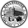
In 1836, Samuel Boyd, known as the "father of the city," and his brother, Joseph, opened the first shoe manufacturing business - an act that would change the community forever. By 1890, with a population of 14,000, Marlborough had become a major shoe manufacturing center, producing boots for Union soldiers as well as footwear for the civilian population. Marlborough became so well known for its shoes that when it was incorporated as a city in 1890, its official seal was decorated with a factory, a shoe box, and a pair of boots.[9]
The Civil War resulted in the creation of one of the region's most unusual historical monuments. Legend has it that a company from Marlborough, assigned to Harpers Ferry, appropriated the bell from the firehouse where John Brown last battled for the emancipation of the slaves. The company left the bell in the hands of one Mrs. Elizabeth Snyder for 30 years, returning in 1892 to bring it back to Marlborough. The bell now hangs in a tower at the corner of Route 85 and Main Street.
Around that time, Marlborough is believed to have been the first community in the country to receive a charter for a streetcar system, edging out Baltimore by a few months. The system, designed primarily for passenger use, provided access to Milford to the south and Concord to the north. As a growing industrialized community, Marlborough began attracting skilled craftsmen from Quebec, Ireland, Italy, and Greece.[9]
Shoe manufacturing continued in Marlborough long after the industry had fled many other New England communities. Rice & Hutchins, Inc. operated several factories in Marlborough from 1875 to 1929. Frye boots were manufactured in the city through the 1970s, and The Rockport Company, founded in Marlborough in 1971, maintained an outlet store in the city until 2017. In 1990, when Marlborough celebrated its centennial as a city, the festivities included the construction of a park in acknowledgment of the shoe industry, featuring statues by the sculptor David Kapenteopolous.
The construction of Interstates 495 and 290 and the Massachusetts Turnpike enabled the growth of the high technology and specialized electronics industries. With its easy access to major highways and the pro-business, pro-development policies of the city government, the population of Marlborough has increased to over 38,000 at the time of the 2010 census. In November 2016, the administration of Massachusetts GovernorCharlie Baker announced a $3 million grant to the city to fund infrastructure improvements along U.S. Route 20 to aid commercial development.[10]
Bird's-eye view c.1912
Main Street in 1906
Shoe factory c.1910
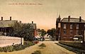
Lincoln Street c.1908
Geography
Marlborough is located at 42°21′3″N71°32′51″W / 42.35083°N 71.54750°W / 42.35083; -71.54750 (42.350909, −71.547530).[11] According to the United States Census Bureau, the city has a total area of 22.2 square miles (57km2), of which 21.1 square miles (55km2) is land and 1.1 square miles (2.8km2) (4.87%) is water. The Assabet River cuts across the northwest corner of the city. Within city limits are three large lakes, known as Lake Williams, Millham Reservoir and Fort Meadow Reservoir. (A portion of Fort Meadow Reservoir extends into nearby Hudson.)
As of the census of 2000, there were 36,255 people, 14,501 households, and 9,280 families residing in the city. The population density was 1,719.4 inhabitants per square mile (663.9/km2). There were 14,903 housing units at an average density of 706.8 per square mile (272.9/km2). The racial makeup of the city was 87.70% White, 2.17% African American, 0.20% Native American, 3.76% Asian, 0.04% Pacific Islander, 3.27% from other races, and 2.86% from two or more races. Hispanic or Latino of any race were 6.06% of the population.[25]
There were 14,501 households, out of which 30.4% had children under the age of 18 living with them, 51.5% were married couples living together, 9.0% had a female householder with no husband present, and 36.0% were non-families. 28.4% of all households were made up of individuals, and 8.3% had someone living alone who was 65 years of age or older. The average household size was 2.47 and the average family size was 3.07.[25]
In the city, the population was spread out, with 23.3% under the age of 18, 7.0% from 18 to 24, 36.7% from 25 to 44, 21.5% from 45 to 64, and 11.6% who were 65 years of age or older. The median age was 36 years. For every 100 females, there were 97.2 males. For every 100 females age 18 and over, there were 94.8 males.[25]
The median income for a household in the city was $56,879, and the median income for a family was $70,385. Males had a median income of $49,133 versus $32,457 for females. The per capita income for the city was $28,723. About 4.7% of families and 6.8% of the population were below the poverty line, including 8.9% of those under age 18 and 10.3% of those age 65 or over.[25]
Marlborough is home to many businesses, stores and restaurants.
The revitalized southwestern corner of the city – locally known as the "Southwest Quadrant" – features numerous office parks and corporate buildings clustered together in a busy industrial core dotted along Forest Street, Cedar Hill Street, Simarano Drive, Ames Street, D’Angelo Drive and Campus Drive (serving The Campus at Marlborough property) with easy access to the Interstate 495 highway.[26] The city’s recent growth of suburban office park infrastructure adjacent to Interstate 495 – which is commonly known as Greater Boston’s outer circumferential highway – is a strategic land usage format comparable to the city of Waltham, which itself has many office parks adjacent to the region’s inner circumferential highway of Massachusetts State Route 128.[27]
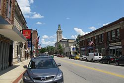
The Marlborough Center Historic District – focused primarily on Main Street in the heart of the city’s downtown area – features restaurants, hair salons, barber shops, insurance agencies and many other businesses.
Marlborough Regional Chamber of Commerce
The Marlborough Regional Chamber of Commerce is the local chamber of commerce for Marlborough and five other surrounding towns in MetroWest Massachusetts. The chamber represents the business needs of over 650 businesses and thousands of employees in the area and is headquartered in the city.
The Chamber of Commerce's role has included working with the MetroWest Regional Transit Authority to improve transportation options and to obtain recognition for Marlborough's Downtown Village as a cultural district.[28]
Immaculate Conception School (Catholic, PS–8) (closed June 2020)
Private schools
Hillside School (5–9)
Wayside Academy (9–12)
Massachusetts International Academy (closed June 2020)
New England Innovation Academy (6–12)
After school programs
Boys & Girls Clubs of Metrowest
Transportation
Marlborough is located near the intersection of Routes 495, 290, 20 and the Massachusetts Turnpike.[29] It is connected to neighboring towns and cities by the Metrowest Regional Transit Authority (MWRTA).[29]
MWRTA Bus Route 7C (Inner City Marlborough) runs roughly east–west through Marlborough. This route operates through downtown Marlborough and connects with multiple shopping complexes/malls, residential localities and Marlborough Hospital. Transfers can be made between Routes 7 and 7C at the Newton & Weed Street bus stop.[33][34]
MWRTA Bus Route 15 connects Marlborough with the town of Hudson to the north. The route begins at the Newton & Weed Street bus stop in downtown Marlborough with intermediate stops at Marlborough Hospital, Boston Scientific and Walmart before reaching its outer terminus at Highland Commons in Hudson. Limited rush hour service on Route 15 is provided between Boston Scientific, the Bolton Street bus shelter (at Marlborough Center) and the MBTA's Southborough Commuter Rail Station. Route 15 passengers can transfer to both Routes 7 and 7C at the Newton & Weed Street bus stop.[35]
Media
Newspapers
Community Advocate, a weekly regional newspaper serving Marlborough and six surrounding communities.
The MetroWest Daily News, a daily newspaper covering Marlborough and surrounding communities in the MetroWest region
The Marlborough Enterprise, the city's weekly newspaper (defunct as of 2021)[36]
Marlborough Patch (online daily)
The Main Street Journal, a weekly newspaper (defunct as of 2021)[37]
Television
Channel 8 (Comcast), Channel 34 (Verizon): WMCT-TV Your Community Station (Marlborough Cable Trust).[38]
Channel 96 (Comcast), Channel 33 (Verizon): Marlborough Access, Public Access Television (Marlborough Cable Trust).
Channel 98: Marlborough Public Schools' student run station
Marlborough District Courthouse, seen from across Lake Williams
Horatio Alger, Jr., author, graduated from high school in Marlborough in 1847 (The city's annual Horatio Alger Street Fair was renamed the Harvest Fair in 2007)
Zach Auguste National Basketball Association player
↑Laidler, John (October 4, 2012). "Mayors, other area notables take sides in Senate race". The Boston Globe. Retrieved September 17, 2015. Marlborough Mayor Arthur G. Vigeant, on the other hand, said he is backing the incumbent senator, Scott Brown, because the fellow Republican from Wrentham 'has been available for us in Marlborough... I think he's done a good job.'
↑"1950 Census of Population"(PDF). Bureau of the Census. 1952. Section 6, Pages 21-10 and 21-11, Massachusetts Table 6. Population of Counties by Minor Civil Divisions: 1930 to 1950. Retrieved July 12, 2011.
↑"1920 Census of Population"(PDF). Bureau of the Census. Number of Inhabitants, by Counties and Minor Civil Divisions. Pages 21-5 through 21-7. Massachusetts Table 2. Population of Counties by Minor Civil Divisions: 1920, 1910, and 1920. Retrieved July 12, 2011.
↑"1890 Census of the Population"(PDF). Department of the Interior, Census Office. Pages 179 through 182. Massachusetts Table 5. Population of States and Territories by Minor Civil Divisions: 1880 and 1890. Retrieved July 12, 2011.
↑"1870 Census of the Population"(PDF). Department of the Interior, Census Office. 1872. Pages 217 through 220. Table IX. Population of Minor Civil Divisions, &c. Massachusetts. Retrieved July 12, 2011.
↑"1860 Census"(PDF). Department of the Interior, Census Office. 1864. Pages 220 through 226. State of Massachusetts Table No. 3. Populations of Cities, Towns, &c. Retrieved July 12, 2011.
↑"1850 Census"(PDF). Department of the Interior, Census Office. 1854. Pages 338 through 393. Populations of Cities, Towns, &c. Retrieved July 12, 2011.
↑"1950 Census of Population"(PDF). Bureau of the Census. 1952. Section 6, Pages 21-7 through 21-09, Massachusetts Table 4. Population of Urban Places of 10,000 or more from Earliest Census to 1920. Retrieved July 12, 2011.
This page is based on this Wikipedia article Text is available under the CC BY-SA 4.0 license; additional terms may apply. Images, videos and audio are available under their respective licenses.


