Norwood, Massachusetts

Last updated

Norwood, Massachusetts
Norwoodmunicipal.jpg
Seal of Norwood, Massachusetts.png
Norfolk County Massachusetts incorporated and unincorporated areas Norwood highlighted.svg
Location in Norfolk County in Massachusetts
Coordinates: 42°11′40″N71°12′0″W / 42.19444°N 71.20000°W / 42.19444; -71.20000
CountryFlag of the United States.svg United States
State Flag of Massachusetts.svg  Massachusetts
County Norfolk
Settled1678
Incorporated1872
Government
  Type Representative town meeting
Area
  Total10.6 sq mi (27.3 km2)
  Land10.5 sq mi (27.1 km2)
  Water0.1 sq mi (0.2 km2)
Elevation
146 ft (45 m)
Population
 (2020)
  Total31,611
  Density3,010.6/sq mi (1,166.5/km2)
Time zone UTC−5 (Eastern)
  Summer (DST) UTC−4 (Eastern)
ZIP Code
02062
Area code 339 / 781
FIPS code 25-50250
GNIS feature ID0619460
Website www.norwoodma.gov

Norwood is a town and census-designated place in Norfolk County, Massachusetts, United States. Norwood is part of the Greater Boston area. As of the 2020 census, the population was 31,611. [1] The town was named after Norwood, England. Norwood is on the Neponset River, [2] which runs all the way to Boston Harbor from Foxborough.

Contents

History

The Town of Norwood, officially formed in 1872, was until that time part of Dedham, known as the "mother of towns", as fourteen of the present communities of eastern Massachusetts lay within its original borders.[ citation needed ] Long used as a hunting ground by Native Americans, Norwood was first settled by Ezra Morse in 1678. He set up a sawmill in what is now South Norwood, the part of town to which the first concentration of families, almost all of whom were farmers, migrated over the next half-century.[ citation needed ]

During the American Revolution, there was a Minuteman company organized in the area.[ citation needed ] Its captain, Aaron Guild, on learning of the British marching on Lexington and Concord to seize the munitions stored there, rode to join the fight and arrived in time to fire on the British at Concord Bridge and participate in the running battle that chased the Redcoats back to Boston.[ citation needed ]

Abraham Lincoln passed through the town during his pre-inaugural tour of New England.[ citation needed ]

The Oak View Mansion, located in Norwood, was built by Francis Olney Winslow.[ citation needed ] Construction began in 1868 and was completed in 1870. Oak View was the scene of almost constant socializing. Some of the most prominent figures hosted in Oak View were President and future Supreme Court Justice William Howard Taft and President Calvin Coolidge.[ citation needed ]

The town shares its name with a town in the borough of Croydon, South London, England. When Norwood separated from Dedham, they considered naming the new community Balch, after the Rev. Thomas Balch. [3]

Geography

Norwood is located at 42°11′9″N71°12′5″W / 42.18583°N 71.20139°W / 42.18583; -71.20139 (42.185974, −71.201661). [4]

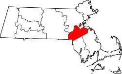
The Town of Norwood is located 13 miles southwest of Boston, placing it in the Boston Metropolitan Area. [5]

According to the United States Census Bureau, the town has a total area of 10.6 square miles (27.3 km2), of which 10.5 square mile (27.1 km2) is land and 0.1 square mile (0.2 km2) (0.66%) is water.

Demographics

Historical population
YearPop.±%
1880 2,845    
1890 3,733+31.2%
1900 5,480+46.8%
1910 8,014+46.2%
1920 12,627+57.6%
1930 15,049+19.2%
1940 15,383+2.2%
1950 16,636+8.1%
1960 24,898+49.7%
1970 30,815+23.8%
1980 29,711−3.6%
1990 28,700−3.4%
2000 28,587−0.4%
2010 28,602+0.1%
2020 31,611+10.5%
2022*31,317−0.9%
* = population estimate. Source: United States Census records and Population Estimates Program data. [6] [7] [8] [9] [10] [11] [12] [13]

As of 2023 Norwood’s racial demographics are [14]

These results seem to underreport the community’s diversity, however. Norwood has many middle eastern families which show up on the census as white. [15]

As of the census [16] of 2010, there were 30,602 people. The racial makeup of the town was 80.92% White, 8.01% Black or African American, 0.09% Native American, 9.57% Asian, 0.01% Pacific Islander, 0.77% from other races, and 1.25% from two or more races. Hispanic or Latino of any race were 3.58% of the population. 27.3% were of Irish descent.

As of the census [16] of 2000, there were 28,587 people, 11,623 households, and 7,380 families residing in the town. The population density was 2,727.0 inhabitants per square mile (1,052.9/km2). There were 11,945 housing units at an average density of 1,139.5 per square mile (440.0/km2). The racial makeup of the town was 90.51% White, 2.31% Black or African American, 0.09% Native American, 5.06% Asian, 0.01% Pacific Islander, 0.77% from other races, and 1.25% from two or more races. Hispanic or Latino of any race were 1.65% of the population. 34.7% were of Irish, 14.8% Italian, 5.4% American and 5.0% English ancestry according to Census 2000.

There were 11,623 households, out of which 27.2% had children under the age of 18 living with them, 50.9% were married couples living together, 9.9% had a female householder with no husband present, and 36.5% were non-families. 29.4% of all households were made up of individuals, and 12.0% had someone living alone who was 65 years of age or older. The average household size was 2.41 and the average family size was 3.05.

In the town, the population was spread out, with 20.8% under the age of 18, 6.4% from 18 to 24, 33.2% from 25 to 44, 22.1% from 45 to 64, and 17.6% who were 65 years of age or older. The median age was 39 years. For every 100 females, there were 89.7 males. For every 100 females age 18 and over, there were 86.5 males.

The median income for a household in the town was $58,421, and the median income for a family was $70,164 (these figures had risen to $66,743 and $80,292 respectively as of a 2007 estimate [17] ). Males had a median income of $50,597 versus $34,312 for females. The per capita income for the town was $27,720. About 2.7% of families and 4.4% of the population were below the poverty line, including 6.5% of those under age 18 and 3.9% of those age 65 or over.

Education

Norwood High School Norwood High School, Norwood MA.jpg
Norwood High School

The Norwood Public Schools operates seven schools, and an additional two school institutions, Little Mustangs Preschool Academy and The Willett Early Childhood Center (serving kindergarten children). The public elementary schools located in Norwood include: Balch, Callahan, Cleveland, Oldham, and Prescott.[ citation needed ]

Norwood has one public middle school, the Dr. Philip O. Coakley Middle School (serving 6th through 8th graders) [18] (formerly Norwood Junior High South), where all five elementary schools combine. Norwood also has a public high school, Norwood High School (NHS), [19] (serves grades 9–12).

Higher education

The Fine Mortuary College in Norwood includes a one-room museum featuring antique embalming tables and centuries-old wooden coffins. [20]

Business

Businesses in Norwood have access to the most educated workforce in the nation, ample venture capital, and several other advantages that help lay the foundation for regional clusters and Norwood's target industries, like advanced manufacturing and life sciences. [21]

Norwood's top employers include Moderna, FM Global, Home Market Foods, MS Walker, and many other manufacturers and businesses engaged in research and development. [22]

Moderna opened its state-of-the-art clinical development site in 2018, employing over 1,400. [23] Moderna's Norwood facilities serve as its primary manufacturing facility and is responsible for producing its COVID-19 vaccine. The facility in Norwood has been expanded to increase the production capacity of Moderna's vaccine and to support the company's research and development efforts. Additionally, Moderna has established partnerships with local organizations in Norwood to support the community, including funding for education and workforce development initiatives.

A large cluster of automobile dealerships on Route 1 is known as the Norwood "Automile."[ citation needed ] The concept of having competing dealerships join together to publicize the "Automile" as an automobile shopping center was largely the work of Ernie Boch, famous in the Boston area for his ads urging people to "Come on down!"[ citation needed ]

The Skating Club of Boston moved to Norwood in 2020.[ citation needed ] The facility, located on University Avenue in Norwood, is a state-of-the-art skating rink home to the Skating Club of Boston's training and development programs for figure skating, ice dancing, and synchronized skating. The Norwood High School hockey teams play at the facility.[ citation needed ] In addition to the rink, the facility features a fitness center, a pro shop, and a cafe. The Skating Club of Boston has a rich history in figure skating and has produced many world champions and Olympic medalists.[ citation needed ]

Architecture

Art

Norwood was the long-time home of photographer and publisher Fred Holland Day.[ citation needed ] As a photographer, Day at one point rivalled Alfred Stieglitz in influence. The publishing firm of Copeland and Day was the American publisher of Oscar Wilde's Salome with illustrations by Aubrey Beardsley.[ citation needed ] The Day House is now a museum and the headquarters of the Norwood Historical Society. F. Holland Day Historic House Museum is located at 93 Day St.[ citation needed ]

Climate

Climate data for Norwood, Massachusetts (Norwood Memorial Airport), 1991−2020 normals, [lower-alpha 1] extremes 1895−present [lower-alpha 2]
MonthJanFebMarAprMayJunJulAugSepOctNovDecYear
Mean daily maximum °F (°C)39.5
(4.2)
42.3
(5.7)
48.9
(9.4)
61.2
(16.2)
71.3
(21.8)
80.4
(26.9)
85.7
(29.8)
84.3
(29.1)
76.8
(24.9)
65.7
(18.7)
54.6
(12.6)
44.3
(6.8)
62.9
(17.2)
Daily mean °F (°C)30.1
(−1.1)
32.0
(0.0)
39.2
(4.0)
50.1
(10.1)
59.6
(15.3)
68.8
(20.4)
74.3
(23.5)
72.4
(22.4)
64.5
(18.1)
53.4
(11.9)
44.1
(6.7)
35.3
(1.8)
52.0
(11.1)
Mean daily minimum °F (°C)20.6
(−6.3)
21.6
(−5.8)
29.5
(−1.4)
39.0
(3.9)
47.9
(8.8)
57.3
(14.1)
62.8
(17.1)
60.6
(15.9)
52.1
(11.2)
41.2
(5.1)
33.6
(0.9)
26.3
(−3.2)
41.0
(5.0)
Average rainfall inches (mm)3.41
(87)
2.80
(71)
3.72
(94)
3.96
(101)
3.30
(84)
3.92
(100)
3.03
(77)
3.63
(92)
3.82
(97)
4.54
(115)
3.69
(94)
4.09
(104)
43.91
(1,115)
Average snowfall inches (cm)15.1
(38)
14.1
(36)
11.6
(29)
2.5
(6.4)
0
(0)
0
(0)
0
(0)
0
(0)
0
(0)
0.3
(0.76)
1.7
(4.3)
10.8
(27)
56.1
(142)
Source: NOAA (snowfall data from WALPOLE 2) [28]

Transportation

Notable people

Notes

  1. Mean monthly maxima and minima (i.e. the highest and lowest temperature readings during an entire month or year) calculated based on data at said location from 1991 to 2020.
  2. Official records for Norwood were kept at the COOP from December 1900 to May 1911, the Weather Bureau Office from June 1911 to February 1937, at various locations in and around the city from March 1937 to July 1942, and at Norwood Memorial Airport since August 1942. For more information, see ThreadEx.

Related Research Articles

<span class="mw-page-title-main">Beverly, Massachusetts</span> City in the United States

Beverly is a city in Essex County, Massachusetts, United States, and a suburb of Boston. The population was 42,670 at the time of the 2020 United States Census. A resort, residential, and manufacturing community on the Massachusetts North Shore, Beverly includes Ryal Side, North Beverly, Montserrat, Beverly Farms and Prides Crossing. Beverly is a rival of Marblehead for the title of being the "birthplace of the U.S. Navy".

<span class="mw-page-title-main">Billerica, Massachusetts</span> Town in Massachusetts, United States

Billerica is a town in Middlesex County, Massachusetts, United States. The population was 42,119 according to the 2020 census. It takes its name from the town of Billericay in Essex, England.

<span class="mw-page-title-main">Everett, Massachusetts</span> City in Massachusetts, United States

Everett is a city in Middlesex County, Massachusetts, United States, directly north of Boston, bordering the neighborhood of Charlestown. The population was 49,075 at the time of the 2020 United States Census.

<span class="mw-page-title-main">Canton, Massachusetts</span> Town in Massachusetts, United States

Canton is a town in Norfolk County, Massachusetts, United States. The population was 24,370 at the 2020 census. Canton is part of Greater Boston, about 15 miles southwest of Downtown Boston.

<span class="mw-page-title-main">Brockton, Massachusetts</span> City in Massachusetts, United States

Brockton is a city in Plymouth County, Massachusetts, United States; the population was 105,643 at the 2020 United States census. Along with Plymouth, it is one of the two county seats of Plymouth County. It is the sixth-largest city in Massachusetts and is sometimes referred to as the "City of Champions", due to the success of native boxers Rocky Marciano and Marvin Hagler, as well as its successful Brockton High School sports programs. Two villages within it are Montello and Campello, both of which have MBTA Commuter Rail Stations and post offices. Campello is the smallest neighborhood, but also the most populous. Brockton hosts a baseball team, the Brockton Rox. It is the second-windiest city in the United States, with an average wind speed of 14.3 mph (23.0 km/h).

<span class="mw-page-title-main">Boylston, Massachusetts</span> Town in Massachusetts, United States

Boylston is a town in Worcester County, Massachusetts, United States. The population was 4,849 at the 2020 census.

<span class="mw-page-title-main">Millville, Massachusetts</span> Town in Massachusetts, United States

Millville is a town in Worcester County, Massachusetts, United States. The population was 3,174 at the 2020 census. It is part of the Providence metropolitan area.

<span class="mw-page-title-main">Petersham, Massachusetts</span> Town in Massachusetts, United States

Petersham is a town in Worcester County, Massachusetts, United States. The population was 1,194 at the 2020 census. Petersham is home to a considerable amount of conservation land, including the Quabbin Reservation, Harvard Forest, the Swift River Reservation, and Federated Women's Club State Forest.

<span class="mw-page-title-main">Lynnfield, Massachusetts</span> Town in Massachusetts, United States

Lynnfield is a town in Essex County, Massachusetts, United States. At the 2020 census, the town population was 13,000.

<span class="mw-page-title-main">Swampscott, Massachusetts</span> Town in Massachusetts, United States

Swampscott is a town in Essex County, Massachusetts, United States, located 15 miles (24 km) up the coast from Boston in an area known as the North Shore. The population was 15,111 as of the 2020 United States Census. A former summer resort on Massachusetts Bay, Swampscott is today a fairly affluent residential community and includes the village of Beach Bluff, as well as part of the neighborhood of Clifton.

<span class="mw-page-title-main">Belmont, Massachusetts</span> Town in eastern Massachusetts

Belmont is a town in Middlesex County, Massachusetts, United States. It is a western suburb of Boston; and is part of the Greater Boston metropolitan area. At the 2020 U.S. census, its population was 27,295, an increase of 10.4% from 2010.

<span class="mw-page-title-main">Burlington, Massachusetts</span> Town in Massachusetts, United States

Burlington is a town in Middlesex County, Massachusetts, United States. The population was 26,377 at the 2020 census.

<span class="mw-page-title-main">Stoneham, Massachusetts</span> Town in Massachusetts, U.S.

Stoneham is a town in Middlesex County, Massachusetts, United States, nine miles (14.5 km) north of downtown Boston. Its population was 23,244 at the 2020 census. Its proximity to major highways and public transportation offers convenient access to Boston and the North Shore coastal region and beaches of Massachusetts. The town is the birthplace of the Olympic figure-skating medalist Nancy Kerrigan and is the location of the Stone Zoo.

<span class="mw-page-title-main">Winchester, Massachusetts</span> Town in Massachusetts, United States

Winchester is a town in Middlesex County, Massachusetts, United States, located 8.2 miles (13.2 km) north of downtown Boston as part of the Greater Boston metropolitan area. It is also one of the wealthiest municipalities in Massachusetts. The population was 22,970 at the 2020 United States Census.

<span class="mw-page-title-main">Wellesley, Massachusetts</span> Town in Massachusetts, United States

Wellesley is a town in Norfolk County, Massachusetts, United States. Wellesley is part of Greater Boston. The population was 29,550 at the time of the 2020 census. Wellesley College, Babson College, and a campus of Massachusetts Bay Community College are located in the town.

<span class="mw-page-title-main">Sharon, Massachusetts</span> Town in Massachusetts, United States

Sharon is a New England town in Norfolk County, Massachusetts, United States. The population was 18,575 at the 2020 census. Sharon is part of Greater Boston, about 17 miles (27 km) southwest of downtown Boston, and is connected to both Boston and Providence by the Providence/Stoughton Line.

<span class="mw-page-title-main">Walpole, Massachusetts</span> Town in Massachusetts, United States

Walpole is a town in Norfolk County, Massachusetts, United States. Walpole Town, as the Census refers to it, is located approximately 18 miles (29 km) south of downtown Boston, Massachusetts, and 30 miles (48 km) north of Providence, Rhode Island. The population of Walpole was 26,383 at the 2020 census. Walpole was first settled in 1659 and was considered a part of Dedham until officially incorporated in 1724. The town was named after Sir Robert Walpole, de facto first Prime Minister of Great Britain. It also encompasses the entirely distinct entity of Walpole (CDP), with its much smaller area of 2.9 square miles.

<span class="mw-page-title-main">Clinton, Massachusetts</span> Town in Massachusetts, United States

Clinton is a town in Worcester County, Massachusetts, United States. The population was 15,428 at the 2020 census.

<span class="mw-page-title-main">Lunenburg, Massachusetts</span> Town in Massachusetts, United States

Lunenburg is a town in Worcester County, Massachusetts, United States. The population was 11,946 at the 2020 census.

<span class="mw-page-title-main">Webster, Massachusetts</span> Town in Massachusetts, United States

Webster is a town in Worcester County, Massachusetts, United States. The population was 17,776 at the 2020 census.

References

  1. "Census - Geographic Profile: Norwood town, Norfolk County, Massachusetts". United States Census Bureau. Retrieved September 18, 2021.
  2. "Welcome to the Neponset River Watershed". Neponset.org. Retrieved July 31, 2012.
  3. Cole, Brad (March 5, 2013). "Balch School to celebrate its centennial". Norwood Transcript. Archived from the original on July 11, 2019. Retrieved July 11, 2019.
  4. "US Gazetteer files: 2010, 2000, and 1990". United States Census Bureau. February 12, 2011. Retrieved April 23, 2011.
  5. "The Norwood, MA Advantage".
  6. "TOTAL POPULATION (P1), 2010 Census Summary File 1, All County Subdivisions within Massachusetts". United States Census Bureau. Archived from the original on February 12, 2020. Retrieved September 13, 2011.
  7. "Massachusetts by Place and County Subdivision - GCT-T1. Population Estimates". United States Census Bureau. Archived from the original on November 3, 2011. Retrieved July 12, 2011.
  8. "1990 Census of Population, General Population Characteristics: Massachusetts" (PDF). US Census Bureau. December 1990. Table 76: General Characteristics of Persons, Households, and Families: 1990. 1990 CP-1-23. Archived from the original (PDF) on December 7, 2013. Retrieved July 12, 2011.
  9. "1980 Census of the Population, Number of Inhabitants: Massachusetts" (PDF). US Census Bureau. December 1981. Table 4. Populations of County Subdivisions: 1960 to 1980. PC80-1-A23. Retrieved July 12, 2011.
  10. "1950 Census of Population" (PDF). Bureau of the Census. 1952. Section 6, Pages 21-10 and 21-11, Massachusetts Table 6. Population of Counties by Minor Civil Divisions: 1930 to 1950. Retrieved July 12, 2011.
  11. "1920 Census of Population" (PDF). Bureau of the Census. Number of Inhabitants, by Counties and Minor Civil Divisions. Pages 21-5 through 21-7. Massachusetts Table 2. Population of Counties by Minor Civil Divisions: 1900, 1910, and 1920. Retrieved July 12, 2011.
  12. "1890 Census of the Population" (PDF). Department of the Interior, Census Office. Pages 179 through 182. Massachusetts Table 5. Population of States and Territories by Minor Civil Divisions: 1880 and 1890. Retrieved July 12, 2011.
  13. "City and Town Population Totals: 2020-2022". United States Census Bureau . Retrieved November 10, 2023.
  14. "Norwood, Massachusetts Population 2023". worldpopulationreview.com. Retrieved September 27, 2023.
  15. Wang, Hansi Lo (April 7, 2023). "New Latino and Middle Eastern". NPR.org.
  16. 1 2 "U.S. Census website". United States Census Bureau . Retrieved January 31, 2008.
  17. "American FactFinder". Factfinder.census.gov. Archived from the original on February 16, 2020. Retrieved July 31, 2012.
  18. "Welcome to the Dr. Philip O. Coakley Middle School". www.norwood.k12.ma.us. Archived from the original on March 2, 2009.
  19. "Welcome to Norwood High School in Norwood Massachusetts". www.norwood.k12.ma.us. Archived from the original on February 4, 2009.
  20. Brad Kelly (January 20, 2006). "DYING TO VISIT? FUNERAL INDUSTRY FASCINATION GROWS: Mortuary school in Norwood opens museum to the public". Patriot Ledger. Retrieved July 6, 2006.[ permanent dead link ]; College website
  21. "Clusters/Target Industries".
  22. "Top Private Employers in Norwood". www.norwoodma.gov. Retrieved February 14, 2023.
  23. "Our Story".
  24. Towerbells.org database: "Traditional carillon of 50 bells...Year of latest technical information source is 2015"
  25. World Carillon Federation, "Bells: 50"
  26. Norwood Library: Norwood Historical Records Archived November 24, 2015, at the Wayback Machine , "The building's 170-foot tower accommodates a 50 bell carillon"
  27. Boston Globe, South Regional edition 7/6/2013, Jean Lang: Norwood Town Hall gets a makeover: "Another concern is the carillon within the tower. There are 50 large bells that have been covered with blankets to protect them, but the blankets have to be taken on and off for the summer carillon concert series, which runs from July 1 to Aug. 19."
  28. "NowData - NOAA Online Weather Data". National Oceanic and Atmospheric Administration . Retrieved May 15, 2021.
  29. "System Map". Massachusetts Bay Transportation Authority.
  30. "MyFoxBoston". Archived from the original on October 18, 2007. Retrieved September 30, 2007.
  31. "The Automatic Life: Billionaire Ernie Boch Jr". Huffington Post. February 14, 2014.
  32. "Charlie Bowles Statistics and History". Baseball-Reference.com. Retrieved July 31, 2012.
  33. "Marty Callaghan Statistics and History". Baseball-Reference.com. Retrieved July 31, 2012.
  34. "Allen Doyle Official Profile". PGATOUR.com. July 26, 1948. Archived from the original on September 30, 2007. Retrieved July 31, 2012.
  35. Alfred Fincher (January 1, 2012). "Alfred Fincher, LB at". Nfl.com. Retrieved July 31, 2012.
  36. "The Long-Lost Tale of the World's Longest Book". The New Yorker . July 20, 2015. Archived from the original on June 29, 2023.
  37. "Ultimate Mets Database - Richie Hebner". Ultimatemets.com. Retrieved July 31, 2012.
  38. Falla, Brian (2006), "Norwood's Natural", The Norwood Bulletin, October 5, 2006, p. 2. "Hebner's ties to Norwood remain a backbone of the story", a description of the making of a two-hour documentary on Hebner
  39. "Joe Allan Hulbig". www.legendsofhockey.net. Archived from the original on March 15, 2016.
  40. Rhoda Leonard Obituary. AAGPBL official website. Retrieved on November 30, 2015.
  41. "Skip Lockwood Statistics and History". Baseball-Reference.com. Retrieved July 31, 2012.
  42. "Ray Martin Statistics and History". Baseball-Reference.com. Retrieved July 31, 2012.
  43. Baker, Billy (June 24, 2007). "The Coolest Cruciverbalist". Boston Globe Magazine . Retrieved April 16, 2019.
  44. "Allen Ripley Statistics and History". Baseball-Reference.com. Retrieved July 31, 2012.
  45. GS Web Mistress (July 27, 2012). "Home". Godsmack. Retrieved July 31, 2012.
  46. "5 Things You Didn't Know About New 'Red Eye' Host Tom Shillue". June 22, 2015. Retrieved June 19, 2018.
  47. "Mike Smith Statistics and History". Baseball-Reference.com. Retrieved July 31, 2012.
  48. Sullivan, George (February 18, 2020). "Honorable George SULLIVAN Jr". Legacy.com Obituaries. Archived from the original on February 18, 2020. Retrieved February 18, 2020.
  49. "Robert Sullivan".
  50. "Bill Travers Statistics and History". Baseball-Reference.com. Retrieved July 31, 2012.