Everett, Massachusetts

Last updated

Everett, Massachusetts
Everett winter.jpg
Aerial view of Everett, looking towards the Mystic Generating Station
Everett Flag.jpg
Seal of Everett, MA.png
Motto(s): 
"City of Pride, Progress, and Possibilities" [1]
Middlesex County Massachusetts incorporated and unincorporated areas Everett highlighted.svg
Location in Middlesex County in Massachusetts
Usa edcp location map.svg
Red pog.svg
Everett, Massachusetts
Location in the United States
Coordinates: 42°24′30″N71°03′15″W / 42.40833°N 71.05417°W / 42.40833; -71.05417
CountryUnited States
State Massachusetts
County Middlesex
Settled1630
Incorporated1870
City1892
Government
  Type Mayor-council city
   Mayor Carlo DeMaria, Jr.
Area
[2]
  Total3.66 sq mi (9.48 km2)
  Land3.42 sq mi (8.85 km2)
  Water0.25 sq mi (0.64 km2)
Elevation
10 ft (3 m)
Population
 (2020)
  Total49,075
  Density14,366.22/sq mi (5,546.12/km2)
Time zone UTC−5 (EST)
  Summer (DST) UTC−4 (EST)
ZIP code
02149
Area code 617 / 857
FIPS code 25-21990
GNIS feature ID0612739
Website cityofeverett.com

Everett is a city in Middlesex County, Massachusetts, United States, directly north of Boston, bordering the neighborhood of Charlestown. The population was 49,075 at the time of the 2020 United States Census. [3]

Contents

Everett was the last city in the United States to have a bicameral legislature, [4] which was composed of a seven-member Board of Aldermen and an eighteen-member Common Council. On November 8, 2011, the voters approved a new City Charter that changed the City Council to a unicameral body with eleven members – six ward councilors and five councilors-at-large. The new City Council was elected during the 2013 City Election.

History

Everett was originally part of Charlestown, and later Malden. It separated from Malden in 1870. [5] The community was named after Edward Everett, [6] who served as U.S. Representative, U.S. Senator, the 15th Governor of Massachusetts, Minister to Great Britain, and United States Secretary of State. He also served as President of Harvard University. [7]

In 1892, Everett was upgraded from a town to a city. On December 13, 1892, Alonzo H. Evans defeated George E. Smith to become Everett's first mayor. [8] Landfill has expanded the Everett shoreline over the centuries. [9] At some point between 1905 [10] and 1912, [11] it connected the mainland to what was formerly White Island in the Mystic River. The bridge of the Grand Junction Railroad was originally built using this island for part of the crossing.

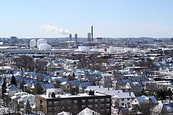
In 1919, Beacon Oil began construction of an oil refinery and storage yard near the Mystic River, opening in 1920. [12] In its first decade, the facility experienced five major explosions or fires. In 1929, Beacon Oil was purchased by Standard Oil of New Jersey, also known as Esso and now known as ExxonMobil. The refinery shut down in 1965 due to lack of profitability, [13] but the tank storage remained.

In 1971, Distrigas of Massachusetts began importing liquefied natural gas (LNG) at its Everett Marine Terminal in the Island End section of Everett. [14] This terminal was the first of its kind in the country. [15] It was purchased by GDF Suez North America, [16] and as of 2013, supplied 20% of New England's natural gas demand from its two tanks with a combined capacity of 3,400,000,000 cu ft (96,000,000 m3), equal to approximately one day of Massachusetts gas demand. [17] In 2019, it was purchased by Constellation Energy, at the time a subsidiary of Exelon. [18] As of 2023, it receives 99% of LNG imports into the United States, [19] mostly from Algeria and Trinidad. LNG is trucked to other storage sites around the state [20] or heated to gas form and transferred by pipeline.

On September 16, 2014, the Massachusetts Gaming Commission voted to approve  Wynn Resorts' proposal for a $1.6 billion casino to be located on a 33-acre site on the Mystic River in Everett. [21] The casino, named Encore Boston Harbor, opened on June 23, 2019. [22] After a remediation process to clean the site, Wynn Resorts constructed [23] Encore Boston as an integrated resort with a hotel, a harborwalk, restaurants, a casino, spa, retail outlets, and meeting and convention space. [24] Public amenities along the year-round harborwalk include a picnic park, paths for bikers and pedestrians, viewing decks, waterfront dining and retail, [25] a performance lawn, floral displays, [26] and boat docks. [27] Wynn Resorts described the $2.6 billion development as "the largest private single-phase construction project in the history of the Commonwealth of Massachusetts." [28]

Most the remaining land south of the Newburyport/Rockport Line and Massachusetts Route 99 in Everett is taken up by a tank farm and oil terminal on the Mystic River. In December 2023, the Conservation Law Foundation announced it had settled a federal pollution lawsuit with Exxon. The company sold the site for cleanup and redevelopment starting with raising the land to avoid climate change-related flooding and adding apartment buildings near Route 16. Exxon also agreed to a deed restriction which prevents the land from ever being used for fossil fuel storage in the future. [29]

Everett has an increasing population as people are seeking new households near downtown Boston while not wanting to pay the higher prices of living now associated with surrounding municipalities, such as those in neighborhoods of Boston, Cambridge, or Somerville.

Geography

Everett is bordered by Malden on the north, Revere on the east, Chelsea on the southeast, Somerville and Medford on the west, and Boston and the Mystic River on the south at Charlestown. Island End River flows through the city, though it was contained in a culvert and invisible to residents until being partly unearthed in 2021. [30] Everett is a major part of the Port of Boston.

Some of Everett's neighborhoods are Glendale, Woodlawn, the Village, and the Line. Glendale Park is the city's largest park.

According to the United States Census Bureau, the city has a total area of 3.7 square miles (9.6 km2), of which 3.4 square miles (8.8 km2) is land and 0.3 square miles (0.78 km2) (7.63%) is water.

Climate

In a typical year, Everett, Massachusetts temperatures fall below 50 °F (10 °C) for 195 days per year. Annual precipitation is typically 44.2 inches per year (high in the US) and snow covers the ground 52 days per year, or 14.2% of the year (high in the US). It may be helpful to understand the yearly precipitation by imagining nine straight days of moderate rain per year. The humidity is below 60% for approximately 25.4 days, or 7% of the year. [31]

Demographics

Historical population
YearPop.±%
1870 2,220    
1880 4,159+87.3%
1890 11,068+166.1%
1900 24,336+119.9%
1910 33,484+37.6%
1920 40,120+19.8%
1930 48,424+20.7%
1940 46,784−3.4%
1950 45,982−1.7%
1960 43,544−5.3%
1970 42,485−2.4%
1980 37,195−12.5%
1990 35,701−4.0%
2000 38,037+6.5%
2010 41,667+9.5%
2020 49,075+17.8%
2022*49,350+0.6%
* = population estimate. Source: United States Census records and Population Estimates Program data. [32] [33] [34] [35] [36] [37] [38] [39] [40] [41]
Source:
U.S. Decennial Census [42]

As of the 2020 United States census, there were 49,075 people, 15,435 households, and 9,554 families residing in the city. The population density was 11,241.1 inhabitants per square mile (4,340.2/km2). There were 15,908 housing units at an average density of 4,701.3 per square mile (1,815.2/km2). The racial makeup of the city was 53.6% Non-Hispanic Whites, 14.3% African American, 4.8% Asian, 0.4% Pacific Islander, 2% from other races, and 3.8% were multiracial. Hispanic or Latino of any race were 21.1% of the population (9.3% Salvadoran, 3.0% Puerto Rican, 1.1% Colombian, 1.1% Dominican, 1.0% Guatemalan, 0.8% Mexican). [43] The city also has a large number of people of Brazilian and Italian descent. [44] In 2010, 33% of the residents of Everett were born outside the United States. This percentage was around 11% in 1990. [45]

There were 15,435 households, out of which 27.6% had children under the age of 18 living with them, 41.8% were married couples living together, 15.2% had a female householder with no husband present, and 38.1% were non-families. 31.3% of all households were made up of individuals, and 11.8% had someone living alone who was 65 years of age or older. The average household size was 2.45 and the average family size was 3.11.

The population was spread out, with 21.6% under the age of 18, 8.9% from 18 to 24, 34.8% from 25 to 44, 19.9% from 45 to 64, and 14.7% who were 65 years of age or older. The median age was 36 years. For every 100 females, there were 91 males. For every 100 females age 18 and over, there were 87.4 males.

The median income for a household in the city was $49,737. The median income for a family is $49,876. Males had a median income of $36,047 versus $30,764 for females. The per capita income for the city was $23,876. About 9.2% of families and 11.9% of the population were below the poverty line, including 16.9% of those under age 18 and 10.0% of those age 65 or over.

Government

Local

Everett has a mayor-council form of government, where the mayor serves a four-year term. The Everett city council was the last existing bicameral legislature in any American city, consisting of a Board of Aldermen and a Common Council. As of November 8, 2011, it became a unicameral City Council. [46]

Board of Aldermen

The Board of Aldermen consisted of seven members one from each of the city's six wards and one Alderman-at-Large. All Aldermen were elected citywide for a term of two years.

In addition to the duties they shared with the Common Council, the Board of Aldermen was the licensing authority in the city and approved licenses for motor dealers, second-hand dealers, awnings, lodging houses, junk dealers, pool tables, open-air parking lots, coin-operated devices, Lord's Day licenses, antique and precious metal dealers.

Common Council

The Common Council consisted of three members elected per ward for a total of eighteen members. The Common Council shared equal responsibility for most legislative actions with the exception of licensing and confirmation of most Mayoral appointees.

State

Everett is represented in the state legislature by officials elected from the following districts:

Voter party enrollment

Voter registration and party enrollment as of October 17, 2018 [49]
PartyNumber of VotersPercentage
Democratic 9,60646.54%
Republican 1,0575.12%
Unaffiliated9,72047.09%
Libertarian 560.27%
Total20,641100%

Education

Everett has ten public schools, which include elementary schools, K–8 schools, and Everett High School. [50] The city also has one Private K–8 school and had a private Catholic high school, Pope John XXIII High School, which was forced, due to financial difficulties, to close on May 31, 2019. Everett High School moved to its new location at 100 Elm Street [51] beginning in the 2007–2008 school year.

Landmarks

Part of the historic Revere Beach Parkway, listed on the National Register of Historic Places, lies in Everett.

Economy

The Mystic Generating Station has been producing electricity since the early twentieth century. It was built by Boston Edison and is now operated by Exelon. It has the largest capacity of any electrical plant in the state.

The Leavitt Corporation has been manufacturing its trademark Teddie Peanut Butter in the city since 1924.

Besides Everett Square, Gateway Center just off Route 16 in Everett is a major retail shopping district with big box stores.

Transportation

Everett's business district is focused on Broadway (part of Route 99), with many businesses and restaurants along the route. The Massachusetts Bay Transportation Authority (MBTA) operates public buses through the city, which includes several routes that converge at a hub at Everett Square. A bus lane exists on Broadway, from Glendale Square (Ferry Street), to Sweetser Circle. MBTA also operates a subway system that includes Wellington, which lies just west of the Everett city limits in nearby Medford, and a commuter rail system with a stop in Chelsea to the southeast. Route 16 traverses the southern area of the city, providing access to U.S. Route 1 and Interstate 93. Both highways run just outside of the city limits and provide connections to Boston.

Notable people

See also Category:People from Everett, Massachusetts

View of Everett Square in 1902 Everett Square, Everett, MA.jpg
View of Everett Square in 1902
1852 Map of the Boston area showing South Malden, which later became Everett 1852 Middlesex Canal (Massachusetts) map.jpg
1852 Map of the Boston area showing South Malden, which later became Everett

Related Research Articles

<span class="mw-page-title-main">Middlesex County, Massachusetts</span> County in Massachusetts, United States

Middlesex County is a county located in the Commonwealth of Massachusetts, United States. As of the 2020 census, the population was 1,632,002, making it the most populous county in both Massachusetts and New England and the 22nd most populous county in the United States. Middlesex County is one of two U.S. counties to be amongst the top 25 counties with the highest household income and the 25 most populated counties. It is included in the Census Bureau's Boston–Cambridge–Newton, MA–NH Metropolitan Statistical Area. As part of the 2020 United States census, the Commonwealth's mean center of population for that year was geo-centered in Middlesex County, in the town of Natick.

<span class="mw-page-title-main">Suffolk County, Massachusetts</span> County in Massachusetts, United States

Suffolk County is located in the Commonwealth of Massachusetts, in the United States. As of the 2020 census, the population was 797,936, making it the fourth-most populous county in Massachusetts. The county comprises the cities of Boston, Chelsea, Revere, and Winthrop. The traditional county seat is Boston, the state capital and the largest city in Massachusetts. The county government was abolished in 1999, and so Suffolk County today functions only as an administrative subdivision of state government and a set of communities grouped together for some statistical purposes. Suffolk County is located at the core of the Boston-Cambridge-Newton, MA-NH Metropolitan Statistical Area as well as the greater Boston-Worcester-Providence, MA-RI-NH-CT Combined Statistical Area.

<span class="mw-page-title-main">Alford, Massachusetts</span> Town in Massachusetts, United States

Alford is a town in Berkshire County, Massachusetts, United States. It is part of the Pittsfield, Massachusetts Metropolitan Statistical Area. The population was 486 at the 2020 census.

<span class="mw-page-title-main">Methuen, Massachusetts</span> City in Massachusetts, United States

Methuen is a 23-square-mile city in Essex County, Massachusetts, United States. The population was 53,059 at the 2020 census. Methuen lies along the northwestern edge of Essex County, just east of Middlesex County and just south of Rockingham County, New Hampshire. The city is bordered by Haverhill to the northeast, North Andover to the southeast, Lawrence and Andover to the south, Dracut to the west, Pelham, New Hampshire to the northwest, and Salem, New Hampshire to the north. Methuen is located 17 miles (27 km) southwest from Newburyport, 30 miles (48 km) north-northwest of Boston and 25 miles (40 km) south-southeast of Manchester, New Hampshire.

<span class="mw-page-title-main">Malden, Massachusetts</span> City in Massachusetts, United States

Malden is a city in Middlesex County, Massachusetts, United States. At the time of the 2020 U.S. Census, the population was 66,263 people.

<span class="mw-page-title-main">Medford, Massachusetts</span> City in Massachusetts, United States

Medford is a city 6.7 miles (10.8 km) northwest of downtown Boston on the Mystic River in Middlesex County, Massachusetts, United States. At the time of the 2020 U.S. Census, Medford's population was 59,659. It is home to Tufts University, which has its campus on both sides of the Medford and Somerville border.

<span class="mw-page-title-main">Melrose, Massachusetts</span> City in Massachusetts, United States

Melrose is a city located in the Greater Boston metropolitan area in Middlesex County, Massachusetts, United States. Its population as of the 2020 census was 29,817. It is a suburb located approximately seven miles north of Boston. It is situated in the center of the triangle created by Interstates 93, 95 and U.S. Route 1.

<span class="mw-page-title-main">Somerville, Massachusetts</span> City in Massachusetts, United States

Somerville is a city located directly to the northwest of Boston, and north of Cambridge, in Middlesex County, Massachusetts, United States. As of the 2020 United States Census, the city had a total population of 81,045 people. With an area of 4.12 square miles (10.7 km2), the city has a density of 19,671/sq mi (7,595/km2), making it the most densely populated municipality in New England and the 19th most densely populated incorporated municipality in the country. Somerville was established as a town in 1842, when it was separated from Charlestown. In 2006, the city was named the best-run city in Massachusetts by The Boston Globe. In 1972, 2009, and 2015, the city received the All-America City Award. It is home to Tufts University, which has its campus along the Somerville and Medford border.

<span class="mw-page-title-main">Woburn, Massachusetts</span> City in Massachusetts, United States

Woburn is a city in Middlesex County, Massachusetts, United States. The population was 40,876 at the 2020 census. Woburn is located 9 miles (14 km) north of Boston. Woburn uses Massachusetts' mayor-council form of government, in which an elected mayor is the executive and a partly district-based, partly at-large city council is the legislature. It was the last of Massachusetts' 351 municipalities to refer to members of its city council as "aldermen".

<span class="mw-page-title-main">Chelsea, Massachusetts</span> City in Massachusetts, United States

Chelsea is a city in Suffolk County, Massachusetts, United States, directly across the Mystic River from Boston. At the 2020 census, Chelsea had a population of 40,787, making it the second most densely populated city in Massachusetts, behind Somerville. With a total area of 2.46 square miles (6.4 km2), Chelsea is the smallest city in Massachusetts in terms of total area. It is the city with the second-highest percentage of Latino residents in Massachusetts, behind Lawrence.

<span class="mw-page-title-main">Revere, Massachusetts</span> City in Massachusetts, United States

Revere is a city in Suffolk County, Massachusetts, located approximately 5 miles (8.0 km) from downtown Boston. Founded as North Chelsea in 1846, it was renamed in 1871 after Revolutionary War patriot Paul Revere. In 1914, the Town of Revere voted to become a city and was incorporated as a city with the inauguration of its first mayor on January 4, 1915. At the 2020 census, the city had a population of 62,186 inhabitants.

<span class="mw-page-title-main">Arlington, Massachusetts</span> Town in Massachusetts, United States

Arlington is a town in Middlesex County, Massachusetts, United States. The town is six miles (10 km) northwest of Boston, and its population was 46,308 at the 2020 census.

<span class="mw-page-title-main">Charlestown, Boston</span> Neighborhood in Boston, Massachusetts, United States

Charlestown is the oldest neighborhood in Boston, Massachusetts, in the United States. Also called Mishawum by the Massachusett, it is located on a peninsula north of the Charles River, across from downtown Boston, and also adjoins the Mystic River and Boston Harbor waterways. Charlestown was laid out in 1629 by engineer Thomas Graves, one of its earliest settlers, during the reign of Charles I of England. It was originally a separate town and the first capital of the Massachusetts Bay Colony.

<span class="mw-page-title-main">Stoneham, Massachusetts</span> Town in Massachusetts, U.S.

Stoneham is a town in Middlesex County, Massachusetts, United States, nine miles (14.5 km) north of downtown Boston. Its population was 23,244 at the 2020 census. Its proximity to major highways and public transportation offers convenient access to Boston and the North Shore coastal region and beaches of Massachusetts. The town is the birthplace of the Olympic figure-skating medalist Nancy Kerrigan and is the location of the Stone Zoo.

<span class="mw-page-title-main">Port of Boston</span> Seaport district in Boston, Massachusetts

The Port of Boston is a major seaport located in Boston Harbor and adjacent to the City of Boston. It is the largest port in Massachusetts and one of the principal ports on the East Coast of the United States.

<span class="mw-page-title-main">Charlestown Elevated</span> Former elevated railway in Greater Boston

The Charlestown Elevated was a segment of the MBTA Orange Line rapid transit line that ran from the Canal Street Incline in downtown Boston, Massachusetts through Charlestown to a terminal in Everett, Massachusetts. It opened in June 1901 and was replaced by the Haymarket North Extension in April 1975.

<span class="mw-page-title-main">Massachusetts's 7th congressional district</span> U.S. House district for Massachusetts

Massachusetts's 7th congressional district is a congressional district located in eastern Massachusetts, including roughly three-fourths of the city of Boston and a few of its northern and southern suburbs. The seat is currently held by Democrat Ayanna Pressley.

<span class="mw-page-title-main">Massachusetts Route 99</span> North-south state highway in Massachusetts, US

Route 99 is a 6.67-mile-long (10.73 km) north–south state highway in metropolitan Boston, leading from the Boston neighborhood of Charlestown through the northern suburbs of Everett, Malden, and Melrose, and terminating in Saugus at U.S. Route 1 (US 1).

<span class="mw-page-title-main">Boston</span> Capital of Massachusetts, United States

Boston, officially the City of Boston, is the capital and most populous city in the Commonwealth of Massachusetts in the United States. The city serves as the cultural and financial center of the New England region of the Northeastern United States. It has an area of 48.4 sq mi (125 km2) and a population of 675,647 as of the 2020 census, making it the third-largest city in the Northeast after New York City and Philadelphia. The Greater Boston metropolitan statistical area, including and surrounding the city, is the largest in New England and eleventh-largest in the country.

<span class="mw-page-title-main">Everett station (MBTA)</span> Boston MBTA former subway station

Everett was a rapid transit station in Everett, Massachusetts. It served the MBTA's Orange Line. It opened in 1919 as an extension of the Charlestown Elevated, and served as its northern terminus until the Elevated was closed and demolished in 1975, when it was replaced by the Haymarket North Extension.

References

  1. "City of Everett Massachusetts". City of Everett. Retrieved October 4, 2012.
  2. "2020 U.S. Gazetteer Files". United States Census Bureau. Retrieved May 21, 2022.
  3. https://www.census.gov/quickfacts/fact/table/everettcitymassachusetts/PST045219 [ dead link ]
  4. "City of Everett City Council". City of Everett. Archived from the original on August 26, 2013. Retrieved July 16, 2013.
  5. Hogan, Julia Rich. "Town of Everett / 1870–1892" (PDF). Archived from the original (PDF) on March 1, 2012. Retrieved September 21, 2012.
  6. Gannett, Henry (1905). The Origin of Certain Place Names in the United States. Govt. Print. Off. p.  122.
  7. "Profile for Everett, Massachusetts". ePodunk . Retrieved May 16, 2010.
  8. "City of Everett / 1892–1970" (PDF). Archived from the original (PDF) on March 1, 2012. Retrieved September 21, 2012.
  9. 1848 map of Charlestown and vicinity (Everett was then part of Malden)
  10. 1905 map of Everett
  11. Historical Register, Vol. XV, No. 1, p. 54, Medford Historical Society, Jan. 1912
  12. "Beacon Oil Co. Begins Work on Refinery at Everett Will Turn Out Petroleum Products". The Wall Street Journal. August 7, 1919.
  13. Jarvis, Judy (April 13, 1975). "The Economy: Plans, plans, plans... but no refinery". The Boston Globe.
  14. "Distrigas". Everett Chamber of Commerce. Retrieved June 14, 2016.
  15. Gellerman, Bruce (March 11, 2015). "Old System, New Solution?: Liquefied Natural Gas Could Be Pipeline Alternative". WBUR. Retrieved June 14, 2016.
  16. Everett LNG Terminal at the Crossroads
  17. Old System, New Solution?: Liquefied Natural Gas Could Be Pipeline Alternative
  18. Everett LNG Facility and Constellation LNG Update, Northeast Gas Association pre-winter webinar, December 3, 2019
  19. Top energy regulator warns fossil fuel terminal shutdown could jeopardize heat for millions of Americans
  20. Natural gas distribution
  21. WBUR News & Wire Services (September 16, 2014). "Panel Picks Wynn's Everett Casino Proposal". WBUR. Retrieved September 20, 2014.
  22. Citation error. See inline comment how to fix. [ verification needed ]
  23. Citation error. See inline comment how to fix. [ verification needed ]
  24. Citation error. See inline comment how to fix. [ verification needed ]
  25. Citation error. See inline comment how to fix. [ verification needed ]
  26. Citation error. See inline comment how to fix. [ verification needed ]
  27. Citation error. See inline comment how to fix. [ verification needed ]
  28. Citation error. See inline comment how to fix. [ verification needed ]
  29. Jon Chesto (December 5, 2023). "Davis Cos. completes $72.5 million acquisition of nearly 100-acre Exxon tank farm in Everett". The Boston Globe .
  30. Daniel, Seth (March 21, 2021). "Island End River Unearthed in a Parking Lot – Everett Independent". Everett Independent.
  31. "Climate comfort in Everett, Massachusetts" . Retrieved July 13, 2022.
  32. https://www.census.gov/quickfacts/fact/table/everettcitymassachusetts/PST045219 [ dead link ]
  33. "TOTAL POPULATION (P1), 2010 Census Summary File 1, All County Subdivisions within Massachusetts". United States Census Bureau. Archived from the original on February 12, 2020. Retrieved September 13, 2011.
  34. "Massachusetts by Place and County Subdivision – GCT-T1. Population Estimates". United States Census Bureau. Archived from the original on November 3, 2011. Retrieved July 12, 2011.
  35. "1990 Census of Population, General Population Characteristics: Massachusetts" (PDF). US Census Bureau. December 1990. Table 76: General Characteristics of Persons, Households, and Families: 1990. 1990 CP-1-23. Archived from the original (PDF) on March 13, 2003. Retrieved July 12, 2011.
  36. "1980 Census of the Population, Number of Inhabitants: Massachusetts" (PDF). US Census Bureau. December 1981. Table 4. Populations of County Subdivisions: 1960 to 1980. PC80-1-A23. Retrieved July 12, 2011.
  37. "1950 Census of Population (Volume 1)" (PDF). Bureau of the Census. 1952. Section 6, Pages 21–10 and 21-11, Massachusetts Table 6. Population of Counties by Minor Civil Divisions: 1930 to 1950. Retrieved July 12, 2011.{{cite journal}}: Cite journal requires |journal= (help)
  38. "1920 Census of Population" (PDF). Bureau of the Census. Number of Inhabitants, by Counties and Minor Civil Divisions. Pages 21–5 through 21-7. Massachusetts Table 2. Population of Counties by Minor Civil Divisions: 1920, 1910, and 1920. Retrieved July 12, 2011.
  39. "1890 Census of the Population" (PDF). Department of the Interior, Census Office. Pages 179 through 182. Massachusetts Table 5. Population of States and Territories by Minor Civil Divisions: 1880 and 1890. Retrieved July 12, 2011.
  40. "1870 Census of the Population" (PDF). Department of the Interior, Census Office. 1872. Pages 217 through 220. Table IX. Population of Minor Civil Divisions, &c. Massachusetts. Retrieved July 12, 2011.
  41. "City and Town Population Totals: 2020-2022". United States Census Bureau . Retrieved October 29, 2023.
  42. "Census of Population and Housing". Census.gov. Retrieved June 4, 2015.
  43. "American FactFinder – Results" . Retrieved September 20, 2014.[ permanent dead link ]
  44. "Everett (city) QuickFacts". United States Census Bureau. Archived from the original on July 7, 2013. Retrieved July 16, 2013.
  45. Sacchetti, Maria. "A melting pot stretches out to the suburbs." Boston Globe . September 15, 2010. p. 1 (Archive). Retrieved on September 23, 2014.
  46. Rosenberg, Steven A. (December 8, 2011). "Everett finally abandoning its bicameral government". Boston.com.
  47. Massachusetts General Court, "An Act Establishing Executive Councillor and Senatorial Districts", Session Laws: Acts (2011), retrieved August 23, 2020
  48. "Massachusetts Representative Districts". Sec.state.ma.us. Retrieved August 23, 2020.
  49. "2018 State Party Election Party Enrollment Statistics" (PDF). Massachusetts Elections Division. Retrieved December 6, 2019.
  50. "Contact Information - Everett (00930000)". profiles.doe.mass.edu. Retrieved January 21, 2024.
  51. "New Everett High School - Century Drywall". www.centurydrywallinc.com. Retrieved January 21, 2024.
  52. Davis, Henry Blaine Jr. (1998). Generals In Khaki. Raleigh, NC: Pentland Press. p. 355. ISBN   978-1-5719-7088-6 via Google Books.

Further reading