Westwood, Massachusetts

Last updated

Westwood, Massachusetts
Westwood.JPG
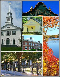
From left to right: Westwood First Parish Church, inscription on town clock, Fisher School House, Hale Reservation, Town Hall, and the Old Burial Ground
Seal of Westwood, Massachusetts.png
Motto: 
"Committed to service"
Norfolk County Massachusetts incorporated and unincorporated areas Westwood highlighted.svg
Location in Norfolk County in Massachusetts
Coordinates: 42°12′50″N71°13′30″W / 42.21389°N 71.22500°W / 42.21389; -71.22500
Country Flag of the United States.svg United States
State Flag of Massachusetts.svg  Massachusetts
County Flag of Norfolk County, Massachusetts.gif Norfolk
Settled1641
Incorporated1897
Government
  Type Open town meeting
Area
  Total28.8 km2 (11.1 sq mi)
  Land28.4 km2 (11.0 sq mi)
  Water0.4 km2 (0.2 sq mi)
Elevation
67 m (220 ft)
Population
 (2020)
  Total16,266
  Density572.7/km2 (1,478.7/sq mi)
Time zone UTC-5 (Eastern)
  Summer (DST) UTC-4 (Eastern)
ZIP code
02090
Area code 339 / 781
FIPS code 25-78690
GNIS feature ID0618333
Website www.townhall.westwood.ma.us

Westwood is a town in Norfolk County, Massachusetts, United States. The population was 16,266 at the 2020 United States Census. [1]

Contents

History

Westwood was first settled in 1641 and was part of the town of Dedham, originally called 'West Dedham', until it was officially incorporated in 1897. It was the last town to split from the original town of Dedham. From early in the settlement of Dedham, the people of the Clapboard Trees Precinct were "a wealthy, sophisticated lot, familiar with the bigwigs of provincial politics and prone to the religious liberalism that was à la mode in Boston." [2] Residents did not care for the politically more powerful Calvinist views of those who lived in the village of Dedham and asked to separate. [3]

It was originally to have been named the "Town of Nahatan:"

a bill to incorporate the Town of Nahatan was reported in the Senate on March 8, 1897, by Senator Charles F. Woodward, Chairman of the Committee on Towns. No opposition to the passage of the bill appeared until it reached the House, when the representative from Nahant objected to the name "Nahatan," owing to its alleged similarity to the name Nahant. It was desirable for the old, as well as the new town, to have the question of incorporation settled, if possible, before April 5, when appropriations for the coming year were going to be made. Therefore, in order to remove every trace of friction, however trivial, and thus expedite matters, the name was changed to Westwood. [4]

In July 2005, CNN/Money and Money magazine ranked Westwood 13th on its list of the 100 Best Places to Live in the United States.
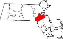
Geography

According to the United States Census Bureau, the town has a total area of 11.1 square miles (29 km2), of which, 11.0 square miles (28 km2) of it is land and 0.2 square miles (0.52 km2) of it (1.35%) is water.

Adjacent towns

Westwood is located in eastern Massachusetts, bordered by:

Demographics

Historical population
YearPop.±%
1900 1,112    
1910 1,266+13.8%
1920 1,358+7.3%
1930 2,097+54.4%
1940 3,376+61.0%
1950 5,837+72.9%
1960 10,354+77.4%
1970 12,750+23.1%
1980 13,212+3.6%
1990 12,557−5.0%
2000 14,117+12.4%
2010 14,618+3.5%
2020 16,266+11.3%
2022*16,231−0.2%
* = population estimate. Source: United States Census records and Population Estimates Program data. [5] [6] [7] [8] [9] [10] [11]

As of the census [12] of 2020, there were 16,266 people and 5,424 households residing in the town with an average household size of 2.94. The population density was 1,478.7 inhabitants per square mile (570.9/km2). The racial makeup of the town was 79.5% White, 2.9% African American, 0.0% Native American, 11.8% Asian, 0.0% from other races, and 4.5% from two or more races. Hispanic or Latino of any race were 3.4% of the population.

The population was spread out with 25.6% under the age of 18, 56.0% between the ages of 18 and 65, and 18.4% age 65 and over. Females were 51.6% of the population

The median household income was $171,071. The per capita income for the town was $75,396. About 2.3% of the population were below the poverty line.

Government

The town of Westwood operates under a home rule charter. This means that the town is given a degree of autonomy in regards to internal affairs. The charter defines the powers of elected boards, including the select board, which serves as the executive branch of government and hires a Town Administrator responsible for day-to-day operations of town departments. The legislative branch operates through open town meeting, which meets at least once and often twice a year where all residents are entitled to speak and vote on approval of warrant articles which authorize the town budget and may create or modify town bylaws. Select Board members and other town officials are elected through an annual town election at the end of April. The select board appoints residents to various volunteer boards and committees. The Town Administrator appoints town staff who manage public safety, recreation, and other services. The Select Board has three members who serve overlapping three-year terms. Michael F. Walsh, John M. Hickey, and Robert Gotti are currently Westwood's Select Board officials. Hickey's term will be up in 2022, Walsh’s in 2023 and Gotti’s in 2024. [13]

The town seal, designed by a descendant of Nathaniel Colburn, includes a drawing of the Town Pound. [14] On May 14, 1700, Lt. Joseph Colburn [lower-alpha 1] was paid "forty shillings of the Town rate" for constructing an animal pound measuring 33' square on his land. [14] [lower-alpha 2] The pound was originally made out of wood and later reconstructed with stone. [14] By including the tree, the new town was paying homage to Dedham, which includes the Avery Oak on its seal. [14] The tree was toppled in the 1938 New England hurricane, but a new oak was planted in its place. [14]

Education

Public schools

Westwood currently has four public elementary schools:

Westood's Pine Hill Elementary school combined the Paul R. Hanlon school with Deerfield when it opened in the 2024-25 school year. [15]

Westwood has one public middle school, Thurston Middle School, [16] named after Edmund W. Thurston. Westwood High School, the only high school in Westwood, serves the Westwood area.

Westwood High School was rebuilt in 2005, and the old school, built in 1957, was demolished. The gymnasium and swimming facility from the old school were refurbished and are part of the new high school campus. The school facilities also include a multi-use artificial turf field (named after former Westwood High School principal and teacher Charles Flahive) with a synthetic track, both of which are open to the public.

Private schools

Westwood is home to Xaverian Brothers High School, an all-boys Catholic prep school and the Westwood Montessori School, preschool.

Points of interest

Houses of worship

Westwood has an active Interfaith Council.

Transportation

Route 128 station, located in the far east corner of Westwood, is served by MBTA Commuter Rail Providence/Stoughton Line service and Amtrak Acela and Northeast Regional service. Islington station is served by MBTA Franklin/Foxboro Line service. MBTA bus route 34E operates through Westwood on Washington Street.

Trivia

Notable people

Notes

  1. Colburn lived from 1662 to 1718. He was the 11th and last child of Nathaniel Colburn. He was a town surveyor and set the boundary between Dedham and Medfield as well as between Dedham and Dorchester. He also laid out highways and cartways in town. Additionally, he was a constable and a tithingman. As such, he was responsible for maintaining moral family order. [14]
  2. In 1639, the land was originally granted to Rev. John Allin. [14]

Related Research Articles

<span class="mw-page-title-main">Dedham, Massachusetts</span> Town in Massachusetts, United States

Dedham is a town in and the county seat of Norfolk County, Massachusetts. Located on Boston's southwest border, the population was 25,364 at the 2020 census.

<span class="mw-page-title-main">Essex County, Massachusetts</span> County in Massachusetts, United States

Essex County is a county in the northeastern part of the U.S. state of Massachusetts. At the 2020 census, the total population was 809,829, making it the third-most populous county in the state, and the seventy-eighth-most populous in the country. It is part of the Greater Boston area. The largest city in Essex County is Lynn. The county was named after the English county of Essex. It has two traditional county seats: Salem and Lawrence. Prior to the dissolution of the county government in 1999, Salem had jurisdiction over the Southern Essex District, and Lawrence had jurisdiction over the Northern Essex District, but currently these cities do not function as seats of government. However, the county and the districts remain as administrative regions recognized by various governmental agencies, which gathered vital statistics or disposed of judicial case loads under these geographic subdivisions, and are required to keep the records based on them. The county has been designated the Essex National Heritage Area by the National Park Service.

<span class="mw-page-title-main">Norfolk County, Massachusetts</span> County in Massachusetts, United States

Norfolk County is located in the U.S. state of Massachusetts. At the 2020 census, the population was 725,981. Its county seat is Dedham. It is the fourth most populous county in the United States whose county seat is neither a city nor a borough, and it is the second most populous county that has a county seat at a town. The county was named after the English county of the same name. Two towns, Cohasset and Brookline, are exclaves.

<span class="mw-page-title-main">Deerfield, Massachusetts</span> Town in Massachusetts, United States

Deerfield is a town in Franklin County, Massachusetts, United States. Settled near the Connecticut River in the 17th century during the colonial era, the population was 5,090 as of the 2020 census. Deerfield is part of the Springfield, Massachusetts Metropolitan Statistical Area in western Massachusetts, lying 30 miles (48 km) north of the city of Springfield.

<span class="mw-page-title-main">Malden, Massachusetts</span> City in Massachusetts, United States

Malden is a city in Middlesex County, Massachusetts, United States. At the time of the 2020 U.S. Census, the population was 66,263 people.

<span class="mw-page-title-main">Weston, Massachusetts</span> Town in Massachusetts, United States

Weston is a town in Middlesex County, Massachusetts, about 15 miles west of Boston. At the time of the 2020 United States Census, the population of Weston was 11,851.

<span class="mw-page-title-main">Canton, Massachusetts</span> Town in Massachusetts, United States

Canton is a town in Norfolk County, Massachusetts, United States. The population was 24,370 at the 2020 census. Canton is part of Greater Boston, about 15 miles southwest of Downtown Boston.

<span class="mw-page-title-main">Millis, Massachusetts</span> Town in Massachusetts, United States

Millis is a town in Norfolk County in the U.S. state of Massachusetts. It had a population of 8,460 at the 2020 census. The town is approximately 19 miles (31 km) southwest of downtown Boston and is bordered by Norfolk, Sherborn, Holliston, Medfield, and Medway. Massachusetts state routes 109 and 115 run through Millis.

<span class="mw-page-title-main">Nahant, Massachusetts</span> Town in Massachusetts, United States

Nahant is a town in Essex County, Massachusetts, United States. The population was 3,334 at the 2020 census, which makes it the smallest municipality by population in Essex County. With just 1.0 square mile (2.7 km2) of land area, it is also the smallest municipality by area in the state. It is primarily a residential community. The town is situated on peninsula consisting of two near-islands connected to the mainland by a narrow sandy isthmus traversed by a single causeway known as "Nahant Road". Numerous tourist beaches line the shores, with the most popular being the so-called "Long Beach" and "Short Beach" along the eastern side of the causeway.

<span class="mw-page-title-main">Belmont, Massachusetts</span> Town in eastern Massachusetts

Belmont is a town in Middlesex County, Massachusetts, United States. It is a western suburb of Boston, Massachusetts, United States; and is part of the Greater Boston metropolitan area. At the 2020 U.S. census, its population was 27,295, up 10.4% from 2010.

<span class="mw-page-title-main">Wilmington, Massachusetts</span> Town in Massachusetts, United States

Wilmington is a town in Middlesex County, Massachusetts, United States. Its population was 23,349 at the 2020 United States census.

<span class="mw-page-title-main">Holbrook, Massachusetts</span> Town in Massachusetts, United States

Holbrook is a town in Norfolk County, Massachusetts, United States. As of 2023, the town's population was 12,284.

<span class="mw-page-title-main">Needham, Massachusetts</span> Town in Massachusetts, United States

Needham is a town in Norfolk County, Massachusetts, United States. A suburb of Boston, its population was 32,091 at the 2020 U.S. Census. It is the home of Olin College.

<span class="mw-page-title-main">Randolph, Massachusetts</span> City in Massachusetts, United States

The Town of Randolph is a suburban city in Norfolk County, Massachusetts, United States. At the 2020 census, the city population was 34,984. Randolph adopted a charter effective January 2010 providing for a council-manager form of government instead of the traditional town meeting. Randolph is one of thirteen Massachusetts municipalities that have applied for, and been granted, city forms of government but wish to retain "The town of" in their official names.

<span class="mw-page-title-main">Walpole, Massachusetts</span> Town in Massachusetts, United States

Walpole is a town in Norfolk County, Massachusetts, United States. Walpole Town, as the Census refers to it, is located about 18 miles (29 km) south of downtown Boston, Massachusetts, and 30 miles (48 km) north of Providence, Rhode Island. The population of Walpole was 26,383 at the 2020 census. Walpole was first settled in 1659 and was considered a part of Dedham until officially incorporated in 1724. The town was named after Sir Robert Walpole, de facto first Prime Minister of Great Britain. It also encompasses the entirely distinct entity of Walpole (CDP), with its much smaller area of 2.9 square miles.

<span class="mw-page-title-main">Dover, Massachusetts</span> Town in Massachusetts, United States

Dover is a town in Norfolk County, Massachusetts, United States. The population was 5,923 at the time of the 2020 United States Census. With a median income of more than $250,000, Dover is the wealthiest town in Massachusetts.

<span class="mw-page-title-main">Greater Boston</span> Metropolitan area in the United States

Greater Boston is the metropolitan region of New England encompassing the municipality of Boston, the capital of the U.S. state of Massachusetts and the most populous city in New England, and its surrounding areas. The region forms the northern arc of the Northeast megalopolis, making Greater Boston both a metropolitan statistical area (MSA) and a combined statistical area (CSA). The most stringent definition of the region consists of most of the eastern third of mainland Massachusetts, excluding the Merrimack Valley and South Coast; while the most expansive definition includes these plus Cape Cod, Central Massachusetts, Rhode Island, southeastern New Hampshire, and Windham County, Connecticut.

<span class="mw-page-title-main">Route 128 station</span> Rail station in Westwood, MA

Route 128 station is a passenger rail station located at the crossing of the Northeast Corridor and Interstate 95/US Route 1/Route 128 at the eastern tip of Dedham and Westwood, Massachusetts, United States. The station is shared by Amtrak and the Massachusetts Bay Transportation Authority (MBTA). It is served by most MBTA Commuter Rail Providence/Stoughton Line trains, as well as by all Amtrak Northeast Regional and Acela intercity trains. The station building, platforms, and parking garage are all fully accessible. It is the 23rd busiest Amtrak station in the country and the fifth busiest in New England.

<span class="mw-page-title-main">Norwood Depot</span> Rail station in Norwood, Massachusetts, US

Norwood Depot is an MBTA Commuter Rail Franklin/Foxboro Line station located in downtown Norwood, Massachusetts. The station has two side platforms serving the two tracks of the Franklin Branch, each with a mini-high section for accessibility. The Norfolk County Railroad opened through South Dedham in 1849, with a station at the modern location. It was renamed Norwood in 1872. The line came under control of the New York, New Haven and Hartford Railroad in 1895. The Massachusetts Bay Transportation Authority (MBTA) began subsidizing service in 1966 and purchased the line in 1973. Under the MBTA, renovations to the station were made around 1977 and 1992.

<span class="mw-page-title-main">Bellingham, Massachusetts</span> Town in Massachusetts, United States

Bellingham is a town in Norfolk County, Massachusetts, United States. The population was 16,945 at the 2020 census. The town sits on the southwestern fringe of Metropolitan Boston, along the rapidly growing "outer belt" that is Interstate 495. It is formally a part of the Boston–Cambridge–Quincy metropolitan statistical area, as well as the Providence metropolitan area.

References

  1. "Census - Geography Profile: Westwood town, Norfolk County, Massachusetts" . Retrieved November 3, 2021.
  2. Lockridge 1985, p. 101.
  3. Lockridge, Kenneth (1985). A New England Town . New York: W.W. Norton & Company. p.  101. ISBN   978-0-393-95459-3.
  4. Dedham Historical Register, Vol. VIII. April, 1897. No. 2, "The New Town of Westwood"
  5. "TOTAL POPULATION (P1), 2010 Census Summary File 1, All County Subdivisions within Massachusetts". United States Census Bureau. Archived from the original on February 12, 2020. Retrieved September 13, 2011.
  6. "Massachusetts by Place and County Subdivision - GCT-T1. Population Estimates". United States Census Bureau. Archived from the original on February 12, 2020. Retrieved July 12, 2011.
  7. "1990 Census of Population, General Population Characteristics: Massachusetts" (PDF). US Census Bureau. December 1990. Table 76: General Characteristics of Persons, Households, and Families: 1990. 1990 CP-1-23. Archived (PDF) from the original on March 13, 2003. Retrieved July 12, 2011.
  8. "1980 Census of the Population, Number of Inhabitants: Massachusetts" (PDF). US Census Bureau. December 1981. Table 4. Populations of County Subdivisions: 1960 to 1980. PC80-1-A23. Archived (PDF) from the original on August 5, 2010. Retrieved July 12, 2011.
  9. "1950 Census of Population" (PDF). 1: Number of Inhabitants. Bureau of the Census. 1952. Section 6, Pages 21-10 and 21-11, Massachusetts Table 6. Population of Counties by Minor Civil Divisions: 1930 to 1950. Archived (PDF) from the original on June 9, 2011. Retrieved July 12, 2011.{{cite journal}}: Cite journal requires |journal= (help)
  10. "1920 Census of Population" (PDF). Bureau of the Census. Number of Inhabitants, by Counties and Minor Civil Divisions. Pages 21-5 through 21-7. Massachusetts Table 2. Population of Counties by Minor Civil Divisions: 1920, 1910, and 1920. Archived (PDF) from the original on August 10, 2010. Retrieved July 12, 2011.
  11. "City and Town Population Totals: 2020-2022". United States Census Bureau . Retrieved November 10, 2023.
  12. "U.S. Census website". United States Census Bureau . Retrieved January 31, 2008.
  13. Westwood, Town Of. "Town Of Westwood, MA Election Results". Westwood MA. Retrieved May 1, 2018.
  14. 1 2 3 4 5 6 7 "Dedham Historical Society & Museum trivia answer". The Dedham Times. Vol. 29, no. 45. November 12, 2021. p. 8.
  15. "New Pine Hill Elementary School on Track for February 2024 Opening". Westwood Minute. Retrieved January 31, 2024.
  16. "Thurston Middle School". Westwood Public Schools. Retrieved December 14, 2016.