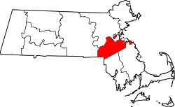
Located about 15 miles (24km) southwest of downtown Boston, Dover is a residential town nestled on the south banks of the Charles River. Almost all of the residential zoning requires 1 acre (4,000m2) or larger. As recently as the early 1960s, 75% of its annual town budget was allocated to snow removal, as only one and a half miles (2.4km) of the town's roads are state highway.
The first recorded settlement of Dover was in 1640. It was later established as the Springfield Parish of Dedham in 1748, and incorporated as District Dedham in 1784. Dover was officially incorporated as a town in 1836.
The Benjamin Caryl House, at 107 Dedham St., dates from about 1777 and was the home of Dover's first minister, Benjamin Caryl, his son George, who was the town's first doctor, and their descendants until 1897. It has been owned by the town and operated by the Historical Society since 1920. The house retains its architectural integrity and has been carefully restored to reflect life in the 1790s when the first two Caryl families lived and worked there together.
The Sawin Building has housed thousands of Dover relics, books, photographs and artifacts since the beginning of the 20th century. Benjamin and Eudora Sawin willed land and funds into the Dover Historical Society along with their old household goods so that the building could be erected, and it was dedicated on May 14, 1907, by members and friends of the society.[3] In the early years, it was used for meetings and to house Dover's historical memorabilia, but eventually members became disenchanted with the society and the building was seldom opened. In the 1960s, there was a renewed interest which led to the general overhaul and refurbishing of the building. The Sawin Museum, located at the corner of Centre and Dedham Streets in Dover Center, is owned and operated by the Dover Historical Society and is open to the public free of charge.
At the 2000 census,[15] there were 5,558 people, 1,849 households and 1,567 families residing in the town. The population density was 362.6 inhabitants per square mile (140.0/km2). There were 1,884 housing units at an average density of 122.9 per square mile (47.5/km2). The racial makeup was 95.18% White, 0.41% Black or African American, 0.04% Native American (2 people), 3.63% Asian, 0.02% Pacific Islander, 0.05% from other races, and 0.67% from two or more races. Hispanic or Latino residents of any race were 1.19% of the population (approximately 105 people).
There were 1,849 households, of which 46.0% had children under the age of 18 living with them, 77.0% were married couples living together, 5.5% had a female householder with no husband present, and 15.2% were non-families. 12.8% of all households were made up of individuals, and 5.9% had someone living alone who was 65 years of age or older. The average household size was 3.01 and the average family size was 3.29.
31.6% of the population were under the age of 18, 3.7% from 18 to 24, 23.9% from 25 to 44, 29.6% from 45 to 64, and 11.2% who were 65 years of age or older. The median age was 40 years. For every 100 females, there were 95.2 males. For every 100 females age 18 and over, there were 92.8 males.
The median household income was $141,818 and the median family income was $157,168. Males had a median income of $100,000 and females $56,473. The per capita income was $64,899. About 2.3% of families and 3.0% of the population were below the poverty line, including 2.5% of those under age 18 and 7.1% of those age 65 or over.
Politics
Historically, Dover was one of the few communities in metropolitan Boston to have more registered Republicans than Democrats, with the most recent Republican nominee winning the town being former Massachusetts governor, Mitt Romney in 2012, defeating Barack Obama 56% to 43%.[16] However, as of 2021 the town had more registered Democrats than Republicans.[17] In 2016, the town flipped, with Democrat Hillary Clinton defeating Republican Donald Trump by 57% to 32%.[18] In 2020, Joe Biden improved Clinton's margin by 16 points, winning it 69% to 28%.
Presidential election results
Dover town vote by Party in presidential elections
Dover's public schools are considered among the best in Massachusetts. According to research conducted by Boston magazine in 2013, 2014, 2015, 2016, 2017, 2018 and 2019, the town's schools scored No. 1 in the state.[59] Dover has three public schools: Chickering Elementary School (grades K–5), Dover-Sherborn Middle School (grades 6–8) and Dover-Sherborn High School (grades 9–12). The private, independent Charles River School (grades Pre-K–8) is located in the town's center.
Located near Caryl Park and the entrance to Noanet Woodlands (also known as Miss Peabody's Woods), Chickering School is under the elected Dover School Committee, while the two secondary schools are the responsibility of the regional school system, under the elected Dover-Sherborn Regional School Committee, with costs and governance shared with the neighboring town of Sherborn. The regional schools share a campus on Farm Street in Dover, near the borders with Sherborn and Medfield.
Dover-Sherborn High School has impressive results with regards to graduation rates, college admission rates and standardized and Advanced Placement exam scores. DSHS was ranked third in cost efficiency and seventh in academic performance by Boston magazine. U.S. News & World Report named Dover-Sherborn a Gold Medal School, ranking it 65th in the US.
Dover used to have two elementary schools, Chickering for grades K to 3, and Caryl Elementary School for grades 4 to 6. In 1970, Caryl School was gutted by fire.[60] It was rebuilt and remained open until finally being closed in 2001 after the expansion of Chickering.[60] The Caryl School's building is now in the process of being renovated into a community center.[61]
Notable people
Soldiers' monument, first dedicated on June 18, 1910
Ian Bowles, environmentalist, businessman, politician, and former Massachusetts Secretary of Energy and Environmental Affairs
George O'Day, Olympic gold medal-winning sailor, 2-time winner of the America's Cup, Sailing Hall of Fame, founder of O'Day Boats
Roy C. Peterson, Chairman of the World Libertarian Order, author of the Nationalist Revolution Novels and the non-fiction Fimbul Winter Books. Search "Roy C. Peterson Short Biography" online.
Bohdan Pomahač, plastic surgeon who led the team that performed the first full face transplant in the United States
Dover Sun House[62] was one of the world's first solar-heated houses, it was designed in 1948 by architect Eleanor Raymond and had a unique heating system developed by physicist Mária Telkes. The project was funded by philanthropist and sculptor Amelia Peabody, and built on her property in Dover, Massachusetts. Dover Sun House was demolished in 2010.
Popular culture
Dover is known for the Dover Demon, a creature supposedly sighted in three separate incidents on April 21 and 22, 1977.[63]
↑"1950 Census of Population"(PDF). Bureau of the Census. 1952. Section 6, Pages 21-10 and 21-11, Massachusetts Table 6. Population of Counties by Minor Civil Divisions: 1930 to 1950. Retrieved July 12, 2011.
↑"1920 Census of Population"(PDF). Bureau of the Census. Number of Inhabitants, by Counties and Minor Civil Divisions. Pages 21-5 through 21-7. Massachusetts Table 2. Population of Counties by Minor Civil Divisions: 1920, 1910, and 1920. Retrieved July 12, 2011.
↑"1890 Census of the Population"(PDF). Department of the Interior, Census Office. Pages 179 through 182. Massachusetts Table 5. Population of States and Territories by Minor Civil Divisions: 1880 and 1890. Retrieved July 12, 2011.
↑"1870 Census of the Population"(PDF). Department of the Interior, Census Office. 1872. Pages 217 through 220. Table IX. Population of Minor Civil Divisions, &c. Massachusetts. Retrieved July 12, 2011.
↑"1860 Census"(PDF). Department of the Interior, Census Office. 1864. Pages 220 through 226. State of Massachusetts Table No. 3. Populations of Cities, Towns, &c. Retrieved July 12, 2011.
↑"1850 Census"(PDF). Department of the Interior, Census Office. 1854. Pages 338 through 393. Populations of Cities, Towns, &c. Retrieved July 12, 2011.
↑"Archived copy"(PDF). Archived(PDF) from the original on April 22, 2021. Retrieved April 22, 2021.{{cite web}}: CS1 maint: archived copy as title (link)
This page is based on this Wikipedia article Text is available under the CC BY-SA 4.0 license; additional terms may apply. Images, videos and audio are available under their respective licenses.