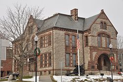
Milford was first settled in 1662 as a part of Mendon after Native Americans, including the Sachem, Quashaamit, granted land to the early settlers. King Philip's War destroyed the town in 1676, but settlers returned in 1680.[2] The Mill River flows through Milford and had several conspicuous fords that were familiar to the Native Americans, and used by the early white settlers. These "mill (river) fords" are said to have given Milford its name.[3] Milford was incorporated April 11, 1780, and the first town hall built in 1819; a brick structure later named the Town House School. The current town hall was built in 1854 by architect Thomas Silloway.[2]
The Milford Hospital was donated in 1903 by Governor Eben Sumner Draper.[2] Today, the health care facility exists as the Milford Regional Medical Center. In January 2008, the Center opened a cancer treatment facility with the Dana–Farber Cancer Institute.[6] The center is affiliated with UMass Medical Center as a teaching hospital.[7] In 2015 the hospital completed a $54-million expansion project that created a new emergency department and updated the intensive care unit, as well as patient rooms.[6]
Geography
According to the United States Census Bureau, the town has a total area of 14.9 square miles (39km2), of which 14.6 square miles (38km2) is land, and 0.3 square miles (0.78km2), or 1.82%, is water. Milford is drained by the Charles River.
As of the census[19] of 2000, there were 26,799 people, 10,420 households, and 7,200 families residing in the town. The population density was 1,835.6 inhabitants per square mile (708.7/km2). There were 10,713 housing units at an average density of 733.8 per square mile (283.3/km2). The racial makeup of the town was 92.95% White; 1.35% Black or African American; 0.11% Native American; 1.76% Asian; 0.06% Pacific Islander; 1.99% from other races; and 1.77% from two or more races. Hispanic or Latino people of any race were 4.36% of the population.
There were 10,420 households, out of which 33.4% had children under the age of 18 living with them; 54.0% were married couples living together; 11.2% had a female householder with no husband present; and 30.9% were non-families. 25.6% of all households were made up of individuals, and 9.5% had someone living alone who was 65 years of age or older. The average household size was 2.54 and the average family size was 3.08.
In the town, the population was spread out, with 24.8% under the age of 18; 6.5% from 18 to 24; 33.2% from 25 to 44; 22.6% from 45 to 64; and 12.9% who were 65 years of age or older. The median age was 37 years. For every 100 females, there were 94.3 males. For every 100 females age 18 and over, there were 90.6 males.
The median income for a household in the town was $50,856, and the median income for a family was $61,029. Males had a median income of $42,173 versus $30,989 for females. The per capita income for the town was $23,742. About 5.8% of families and 7.2% of the population were below the poverty line, including 8.9% of those under age 18 and 10.4% of those age 65 or over.
Economy
Milford has been growing at a fast rate since the introduction of Interstate 495, which opened in the area with dual exits at Route 85 and Route 109 in 1969. Since then many major retailers have opened in town.
The core of Milford's governing system is the representative town meeting, where elected citizens can voice their opinions, but more importantly, directly effect changes in the community. Along with a Board of Selectmen, Town Administrator, Planning Board, Finance Committee, etc., the citizens of Milford have input into how the town is run.
The Milford Town Library was established in 1858.[21][22] In fiscal year 2008, the town of Milford spent 1.5% ($966,758) of its budget on its public library—approximately $35 per person, per year ($42.87 adjusted for inflation to 2021).[23]
Independence Day fireworks, held on Plains Park within a day of July 4. There is also an annual parade.
Portuguese Picnic, a two-night festival held at the Portuguese Club
Irish Round Tower, Milford
Sites of interest
Memorial Hall, home and museum of the Milford Historical Commission
Ted's Diner, placed on the National Register of Historic Places in 2000, was the oldest diner built by the Tierney Diner Company. Ted's was left abandoned by the town and vandalized, eventually moved to make way for a new fire station.
St. Mary's Cemetery holds the only Irish round tower in the United States, built from local granite.
WMRC 1490-AM and simulcasted as MyFM 101.3 on FM is the radio station licensed to serve Milford. Local news every morning with school cancellations and general information also. Local sports broadcasts of the local school teams or the major Boston sports teams can be heard on many nights. A Classic Hits format is the music that is playing when the station is playing music.
This area also receives the major television stations that serve the Boston area, which can be received over the air or through a cable or satellite provider.
In popular culture
Milford was fictitiously featured in a 2008 episode of the Fox television series Fringe.[24]
Notable people
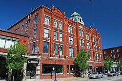
Milford Town Library, 1899
Norm Abram, carpenter and co-host of This Old House; host of the New Yankee Workshop
Adin Ballou, author, religious leader and prominent 19th-century proponent of pacifism, socialism and abolitionism; wrote The History of Milford, Massachusetts, 1882
Nikola Sacco, with Bartolomeo Vanzetti (AKA Sacco and Vanzetti) were Italian immigrants and anarchists who were controversially convicted of murder. Sacco lived in Milford for about seven years.
↑"1950 Census of Population"(PDF). Bureau of the Census. 1952. Section 6, Pages 21-10 and 21-11, Massachusetts Table 6. Population of Counties by Minor Civil Divisions: 1930 to 1950. Retrieved July 12, 2011.
↑"1920 Census of Population"(PDF). Bureau of the Census. Number of Inhabitants, by Counties and Minor Civil Divisions. Pages 21-5 through 21-7. Massachusetts Table 2. Population of Counties by Minor Civil Divisions: 1920, 1910, and 1920. Retrieved July 12, 2011.
↑"1890 Census of the Population"(PDF). Department of the Interior, Census Office. Pages 179 through 182. Massachusetts Table 5. Population of States and Territories by Minor Civil Divisions: 1880 and 1890. Retrieved July 12, 2011.
↑"1870 Census of the Population"(PDF). Department of the Interior, Census Office. 1872. Pages 217 through 220. Table IX. Population of Minor Civil Divisions, &c. Massachusetts. Retrieved July 12, 2011.
↑"1860 Census"(PDF). Department of the Interior, Census Office. 1864. Pages 220 through 226. State of Massachusetts Table No. 3. Populations of Cities, Towns, &c. Retrieved July 12, 2011.
↑"1850 Census"(PDF). Department of the Interior, Census Office. 1854. Pages 338 through 393. Populations of Cities, Towns, &c. Retrieved July 12, 2011.
↑C.B. Tillinghast. The free public libraries of Massachusetts. 1st Report of the Free Public Library Commission of Massachusetts. Boston: Wright & Potter, 1891. Google books
↑July 1, 2007, through June 30, 2008; cf. The FY2008 Municipal Pie: What's Your Share? Commonwealth of Massachusetts, Board of Library Commissioners. Boston: 2009. Available: Municipal Pie ReportsArchived January 23, 2012, at the Wayback Machine . Retrieved August 4, 2010
This page is based on this Wikipedia article Text is available under the CC BY-SA 4.0 license; additional terms may apply. Images, videos and audio are available under their respective licenses.