Milford (CDP), Massachusetts

Last updated
Milford, Massachusetts
CDP
Main Street, Milford MA.jpg
Main Street
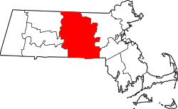
Worcester County Massachusetts incorporated and unincorporated areas Milford (CDP) highlighted.svg
Location in Worcester County and the state of Massachusetts.
Coordinates: 42°8′45″N71°31′8″W / 42.14583°N 71.51889°W / 42.14583; -71.51889 Coordinates: 42°8′45″N71°31′8″W / 42.14583°N 71.51889°W / 42.14583; -71.51889
Country United States
State Massachusetts
County Worcester
Area
[1]
  Total10.39 sq mi (26.91 km2)
  Land10.15 sq mi (26.30 km2)
  Water0.24 sq mi (0.61 km2)
Elevation
259 ft (79 m)
Population
 (2020)
  Total26,971
  Density2,656.19/sq mi (1,025.53/km2)
Time zone UTC-5 (Eastern (EST))
  Summer (DST) UTC-4 (EDT)
ZIP code
01757
Area code(s) 508 / 774
FIPS code 25-41200
GNIS feature ID0611362

Milford is a census-designated place (CDP) in the town of Milford in Worcester County, Massachusetts, United States. The population was 25,055 at the 2010 census.

Contents

Geography

Milford is located at 42°8′44″N71°31′8″W / 42.14556°N 71.51889°W / 42.14556; -71.51889 (42.145828, -71.518975). [2]

According to the United States Census Bureau, the CDP has a total area of 26.5 km2 (10.2 mi2). 25.8 km2 (10.0 mi2) of it is land and 0.6 km2 (0.2 mi2) of it (2.35%) is water.

Demographics

Historical population
CensusPop.
2020 26,971
U.S. Decennial Census [3]

As of the census [4] of 2000, there were 24,230 people, 9,566 households, and 6,447 families residing in the CDP. The population density was 937.4/km2 (2,428.8/mi2). There were 9,834 housing units at an average density of 380.5/km2 (985.8/mi2). The racial makeup of the CDP was 92.53% White, 1.42% Black or African American, 0.12% Native American, 1.82% Asian, 0.07% Pacific Islander, 2.13% from other races, and 1.91% from two or more races. Hispanic or Latino of any race were 4.66% of the population.

There were 9,566 households, out of which 32.3% had children under the age of 18 living with them, 51.7% were married couples living together, 11.7% had a female householder with no husband present, and 32.6% were non-families. 27.0% of all households were made up of individuals, and 10.2% had someone living alone who was 65 years of age or older. The average household size was 2.50 and the average family size was 3.06.

In the CDP, the population was spread out, with 24.3% under the age of 18, 6.7% from 18 to 24, 33.1% from 25 to 44, 22.2% from 45 to 64, and 13.7% who were 65 years of age or older. The median age was 37 years. For every 100 females, there were 93.3 males. For every 100 females age 18 and over, there were 89.6 males.

The median income for a household in the CDP was $47,090, and the median income for a family was $58,321. Males had a median income of $41,250 versus $30,541 for females. The per capita income for the CDP was $22,813. About 6.1% of families and 7.6% of the population were below the poverty line, including 9.6% of those under age 18 and 10.6% of those age 65 or over.

Related Research Articles

Farm Loop, Alaska CDP in Alaska, United States

Farm Loop is a census-designated place (CDP) in Matanuska-Susitna Borough, Alaska, United States. It is part of the Anchorage, Alaska Metropolitan Statistical Area. At the 2020 census the population was 2,747, up from 1,028 in 2010.

Drexel-Alvernon, Arizona CDP in Pima County, Arizona

Drexel-Alvernon was a census-designated place (CDP) in Pima County, Arizona, United States. The population was 4,192 at the 2000 census.

Frankfort Square, Illinois Census-designated place in Illinois, United States

Frankfort Square is a census-designated place (CDP) in Will County, Illinois, United States. So close to also being in Cook County. Cook County is East of Frankfort Square. Frankfort Square will be in 2 countys just like Lakes of the Four Seasons Over in Indiana. Per the 2020 census, the population was 8,968. Frankfort Square has a fountain lake and schools like Lincoln Way North and Summit Hill Junior High.

East Pepperell, Massachusetts Census-designated place in Massachusetts, United States

East Pepperell is a census-designated place (CDP) in the town of Pepperell in Middlesex County, Massachusetts, United States. The population was 2,059 at the 2010 census.

West Concord, Massachusetts CDP in Massachusetts, United States

West Concord is an unincorporated village and census-designated place (CDP) in the town of Concord in Middlesex County, Massachusetts, United States. The population was 6,028 at the 2010 census.

East Douglas, Massachusetts CDP in Massachusetts, United States

East Douglas is a census-designated place (CDP) in the town of Douglas in Worcester County, Massachusetts, United States. The population was 2,557 at the 2010 census.

Zena, New York CDP in New York, United States

Zena is a hamlet in Ulster County, New York, United States. As of the 2010 census the population was 1,031.

East Uniontown, Pennsylvania Census-designated place in Pennsylvania, United States

East Uniontown is a census-designated place (CDP) in Fayette County, Pennsylvania, United States. The population was 2,419 at the 2010 census, down from 2,760 at the 2000 census.

Ashaway, Rhode Island Village and CDP in Hopkinton, Rhode Island, US

Ashaway is an unincorporated village and census-designated place (CDP) in the town of Hopkinton, Rhode Island. It is a principal village of Hopkinton, along with Hope Valley, although it is the smaller of the two. The population was 1,485 at the 2010 census. The name Ashaway is derived from the American Indian name for the river that runs through the village, the Ashawague or Ashawaug, which means "land in the middle" or "land between" in the Niantic and Mohegan languages. The name "Ashawague River" appears as late as 1832 on the Findley map of Rhode Island published in Philadelphia.

Hatfield (CDP), Massachusetts Census-designated place in Massachusetts, United States

Hatfield is a census-designated place (CDP) comprising the main village in the town of Hatfield in Hampshire County, Massachusetts, United States. The population of the CDP was 1,318 at the 2010 census, out of a total town population of 3,279. It is part of the Springfield, Massachusetts Metropolitan Statistical Area.

Ayer (CDP), Massachusetts Census-designated place in Massachusetts, United States

Ayer is a census-designated place (CDP) in the town of Ayer in Middlesex County, Massachusetts, United States. The population was 2,868 at the 2010 census.

Hopedale, Massachusetts Town in Massachusetts, United States

Hopedale is a town in Worcester County, Massachusetts, United States. It is located 25 miles southwest of Boston, in eastern Massachusetts. With origins as a Christian utopian community, the town was later home to Draper Corporation, a large loom manufacturer throughout the 20th century until its closure in 1980. Today, Hopedale has become a bedroom community for professionals working in Greater Boston and is home to highly ranked public schools. The population was 6,017 as of the 2020 census.

Oxford (CDP), Massachusetts CDP in Massachusetts, United States

Oxford is a census-designated place (CDP) in the town of Oxford in Worcester County, Massachusetts, United States. The population was 6,103 at the 2010 census.

Rutland (CDP), Massachusetts CDP in Massachusetts, United States

Rutland is a census-designated place (CDP) in the town of Rutland in Worcester County, Massachusetts, United States. The population was 2,111 at the 2010 census.

Webster (CDP), Massachusetts CDP in Massachusetts, United States

Webster is a census-designated place (CDP) in the town of Webster in Worcester County, Massachusetts, United States. The population was 11,412 at the 2010 census.

Groton (CDP), Massachusetts Census-designated place in Massachusetts, United States

Groton is a census-designated place (CDP) in the town of Groton in Middlesex County, Massachusetts, United States. The population was 1,124 at the 2010 census.

Hudson (CDP), Massachusetts Census-designated place in Massachusetts, United States

Hudson is a census-designated place (CDP) in the town of Hudson in Middlesex County, Massachusetts, United States. The population was 14,907 at the 2010 census.

Pepperell (CDP), Massachusetts Census-designated place in Massachusetts, United States

Pepperell is a census-designated place (CDP) in the town of Pepperell in Middlesex County, Massachusetts, United States. The population was 2,504 at the 2010 census.

Shirley (CDP), Massachusetts Census-designated place in Massachusetts, United States

Shirley is a census-designated place (CDP) in the town of Shirley in Middlesex County, Massachusetts, United States. The population was 1,441 at the 2010 census.

Milford is a census-designated place (CDP) consisting of the main area of settlement within the town of Milford in Penobscot County, Maine, United States. The population was 2,233 at the 2010 census.

References

  1. "2020 U.S. Gazetteer Files". United States Census Bureau. Retrieved May 21, 2022.
  2. "US Gazetteer files: 2010, 2000, and 1990". United States Census Bureau. 2011-02-12. Retrieved 2011-04-23.
  3. "Census of Population and Housing". Census.gov. Retrieved June 4, 2016.
  4. "U.S. Census website". United States Census Bureau . Retrieved 2008-01-31.