Westborough, Massachusetts | |
---|---|
Coordinates: 42°16′11″N71°37′2″W / 42.26972°N 71.61722°W | |
Country | United States |
State | Massachusetts |
County | Worcester |
Area | |
• Total | 1.90 sq mi (4.93 km2) |
• Land | 1.89 sq mi (4.89 km2) |
• Water | 0.02 sq mi (0.04 km2) |
Elevation | 305 ft (95 m) |
Population (2020) | |
• Total | 4,255 |
• Density | 2,253.71/sq mi (870.12/km2) |
Time zone | UTC-5 (Eastern (EST)) |
• Summer (DST) | UTC-4 (EDT) |
ZIP codes | 01580-01582 |
Area code | 508 |
FIPS code | 25-75050 |
GNIS feature ID | 0611409 |
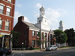
Westborough is a census-designated place (CDP) in the town of Westborough in Worcester County, Massachusetts, United States. The population was 4,045 at the 2010 census.
According to the United States Census Bureau, the CDP has a total area of 4.9 km2 (1.9 mi2), all land. [2]
Census | Pop. | Note | %± |
---|---|---|---|
2020 | 4,255 | — | |
U.S. Decennial Census [3] |
At the 2000 census there were 3,983 people, 1,719 households, and 947 families in the CDP. The population density was 809.4/km2 (2,092.5/mi2). There were 1,781 housing units at an average density of 361.9/km2 (935.7/mi2). The racial makeup of the CDP was 94.38% White, 1.58% Black or African American, 0.23% Native American, 1.96% Asian, 0.65% from other races, and 1.21% from two or more races. Hispanic or Latino of any race were 3.14%. [4]
Of the 1,719 households 27.0% had children under the age of 18 living with them, 44.3% were married couples living together, 8.3% had a female householder with no husband present, and 44.9% were non-families. 36.6% of households were one person and 13.3% were one person aged 65 or older. The average household size was 2.22 and the average family size was 2.99.
The age distribution was 22.0% under the age of 18, 6.0% from 18 to 24, 34.8% from 25 to 44, 20.1% from 45 to 64, and 17.1% 65 or older. The median age was 38 years. For every 100 females, there were 91.1 males. For every 100 females age 18 and over, there were 85.1 males.
The median household income was $47,708 and the median family income was $65,841. Males had a median income of $46,104 versus $34,712 for females. The per capita income for the CDP was $27,119. About 5.7% of families and 6.5% of the population were below the poverty line, including 5.3% of those under age 18 and 12.2% of those age 65 or over.
Pleasant Valley is a census-designated place (CDP) in Fairbanks North Star Borough, Alaska, United States. It is part of the Fairbanks, Alaska Metropolitan Statistical Area. The population was 725 at the 2010 census, up from 623 at the 2000 census.
Womens Bay is a census-designated place (CDP) in Kodiak Island Borough, Alaska, United States. At the 2020 census the population was 743, up from 719 in 2010. The name is correctly spelled "Womens", without an apostrophe.
Boulevard Gardens is a census-designated place (CDP) in Broward County, Florida, United States. The population was 1,457 at the 2020 census.
Villages of Oriole was a census-designated place (CDP) in Palm Beach County, Florida, United States. The population was 4,758 at the 2000 census.
White City is a census-designated place (CDP) in St. Lucie County, Florida, United States. The population was 3,719 at the 2010 census. It is part of the Port St. Lucie Metropolitan Statistical Area.
Waipiʻo Acres is a census-designated place (CDP) in Honolulu County, Hawaiʻi, United States. The population was 5,531 at the 2020 census.
South Gate was a census-designated place (CDP) in Anne Arundel County, Maryland, United States, for the 2000 census, at which time its population was 28,672. It was added primarily to the Glen Burnie CDP for the 2010 census.
Dennis Port is a census-designated place (CDP) in the town of Dennis in Barnstable County, Cape Cod, Massachusetts. At the 2010 census, its population was 3,162.
Wareham Center is a census-designated place (CDP) in the town of Wareham in Plymouth County, Massachusetts, United States. The population was 2,896 at the 2010 census.
Chalco is a census-designated place (CDP) in northern Sarpy County, Nebraska, United States, and an adjacent suburb of Omaha, with La Vista located to the southeast. The population was 11,064 at the 2020 census.
Lucernemines, usually written as Lucerne Mines, is a census-designated place (CDP) in Indiana County, Pennsylvania, United States. The population was 937 at the 2010 census.
Mayo is a census-designated place (CDP) in Spartanburg County, South Carolina, United States. The population was 1,592 at the 2010 census.
Northcliffe is a former census-designated place (CDP) in Guadalupe County, Texas, United States. The population was 1,819 at the 2000 census. The area is now part of the city of Schertz and did not have its population recorded separately at the 2010 census. It is part of the San Antonio Metropolitan Statistical Area.
Sudley is a census-designated place (CDP) in Prince William County, Virginia, United States. As of the 2010 census, Sudley comprises what in the 2000 census were the Sudley and West Gate CDPs. Sudley's population including West Gate was 16,203 at the 2010 census, and excluding West Gate was 7,719 at the 2000 census.
Claypool Hill is a census-designated place (CDP) in Tazewell County, Virginia, United States. The population was 1,776 at the 2010 census, which was up from the 1,719 reported in 2000. Claypool is part of the Bluefield WV-VA micropolitan area which has a population of 107,578.
Central Park is a census-designated place (CDP) in Grays Harbor County, Washington, United States. The population was 2,841 at the 2020 census.
Cross Lanes is a census-designated place (CDP) and suburb of Charleston in Kanawha County, West Virginia, United States. As of the 2010 census, its population was 9,995.
Woods Landing-Jelm is a census-designated place (CDP) in Albany County, Wyoming, United States. The population was 97 at the 2010 census.
Antelope Hills is a census-designated place in Natrona County, Wyoming, United States. It is part of the Casper, Wyoming Metropolitan Statistical Area. The population was 97 at the 2010 census.
Winchendon is a census-designated place (CDP) in the town of Winchendon in Worcester County, Massachusetts, United States. The population was 4,213 at the 2010 census.