West Brookfield (CDP), Massachusetts

Last updated

West Brookfield, Massachusetts
Main Street, West Brookfield MA.jpg
Main Street
Worcester County Massachusetts incorporated and unincorporated areas West Brookfield (CDP) highlighted.svg
Location in Worcester County and the state of Massachusetts.
Coordinates: 42°14′8″N72°8′46″W / 42.23556°N 72.14611°W / 42.23556; -72.14611
Country United States
State Massachusetts
County Worcester
Area
[1]
  Total1.77 sq mi (4.58 km2)
  Land1.26 sq mi (3.27 km2)
  Water0.51 sq mi (1.31 km2)
Elevation
627 ft (191 m)
Population
 (2020)
  Total1,375
  Density1,088.68/sq mi (420.37/km2)
Time zone UTC-5 (Eastern (EST))
  Summer (DST) UTC-4 (EDT)
ZIP code
01585
Area code 508
FIPS code 25-75365
GNIS feature ID0609864

West Brookfield is a census-designated place (CDP) in the town of West Brookfield in Worcester County, Massachusetts, United States. The population was 1,413 at the 2010 census.

Contents

Geography

According to the United States Census Bureau, the CDP has a total area of 4.5 km2 (1.7 mi2), of which 3.2 km2 (1.2 mi2) is land and 1.3 km2 (0.5 mi2) (29.31%) is water. [2]

Demographics

Historical population
CensusPop.Note
2020 1,375
U.S. Decennial Census [3]

As of the census [4] of 2000, there were 1,610 people, 581 households, and 348 families residing in the CDP. The population density was 501.3/km2 (1,301.3/mi2). There were 656 housing units at an average density of 204.3/km2 (530.2/mi2). The racial makeup of the CDP was 98.26% White, 0.25% Native American, 0.25% Asian, 0.06% Pacific Islander, and 1.18% from two or more races. Hispanic or Latino of any race were 0.50% of the population.

There were 581 households, out of which 26.2% had children under the age of 18 living with them, 47.8% were married couples living together, 9.0% had a female householder with no husband present, and 40.1% were non-families. 34.8% of all households were made up of individuals, and 17.0% had someone living alone who was 65 years of age or older. The average household size was 2.19 and the average family size was 2.84.

In the CDP, the population was spread out, with 17.0% under the age of 18, 4.7% from 18 to 24, 21.4% from 25 to 44, 21.1% from 45 to 64, and 35.8% who were 65 years of age or older. The median age was 50 years. For every 100 females, there were 68.2 males. For every 100 females age 18 and over, there were 62.5 males.

The median income for a household in the CDP was $41,875, and the median income for a family was $52,292. Males had a median income of $37,167 versus $27,692 for females. The per capita income for the CDP was $20,712. About 3.3% of families and 7.4% of the population were below the poverty line, including 12.2% of those under age 18 and 5.1% of those age 65 or over.

Related Research Articles

Oak Point was a census-designated place (CDP) in Broward County, Florida, United States. The population was 145 at the 2000 census. It now serves as a Hollywood, Florida neighborhood known for its wealthy residents and beautiful large homes. It is more commonly referred to as Arapahoe.

Royal Palm Estates is a census-designated place (CDP) in Palm Beach County, Florida, United States. It is part of the Miami metropolitan area of South Florida. The population was 1,974 at the 2020 census.

<span class="mw-page-title-main">Marshfield Hills, Massachusetts</span> Census-designated place in Massachusetts, United States

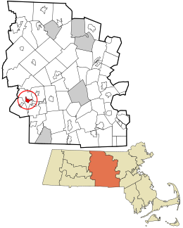
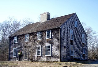
Marshfield Hills is a census-designated place (CDP) in the town of Marshfield in Plymouth County, Massachusetts, United States. The population was 2,356 at the 2010 census. The historic center of the village has been designated a historic district and listed on the National Register of Historic Places.

<span class="mw-page-title-main">West Wareham, Massachusetts</span> Census-designated place in Massachusetts, United States

West Wareham is a census-designated place (CDP) in the town of Wareham in Plymouth County, Massachusetts, United States. The population was 2,064 at the 2010 census.

<span class="mw-page-title-main">East Douglas, Massachusetts</span> CDP in Massachusetts, United States

East Douglas is a census-designated place (CDP) in the town of Douglas in Worcester County, Massachusetts, United States. The population was 2,557 at the 2010 census.

<span class="mw-page-title-main">Fiskdale, Massachusetts</span> CDP in Sturbridge, Massachusetts, United States

Fiskdale is a census-designated place (CDP) in the town of Sturbridge in Worcester County, Massachusetts, United States. The population was 2,583 at the 2010 census.

<span class="mw-page-title-main">Brookfield Center, Ohio</span> Census-designated place in Ohio, United States

Brookfield Center, also referred to as simply Brookfield, is an unincorporated community and census-designated place in central Brookfield Township, Trumbull County, Ohio, United States. The population was 1,141 at the 2020 census. It is part of the Youngstown–Warren metropolitan area.

<span class="mw-page-title-main">Essex (CDP), Massachusetts</span> Census-designated place in Massachusetts, United States

Essex CDP is a census-designated place (CDP) in the town of Essex in Essex County, Massachusetts, United States. The population was 1,471 at the 2010 census.

<span class="mw-page-title-main">Ware (CDP), Massachusetts</span> Census-designated place in Massachusetts, United States

Ware is a census-designated place (CDP) comprising the main village in the town of Ware in Hampshire County, Massachusetts, United States. The population of the CDP was 6,170 at the 2010 census, out of a total town population of 9,872. It is part of the Springfield, Massachusetts Metropolitan Statistical Area.

<span class="mw-page-title-main">Medfield (CDP), Massachusetts</span> CDP in Massachusetts, United States

Medfield is a census-designated place (CDP) in the town of Medfield in Norfolk County, Massachusetts, United States. The population was 6,483 at the 2010 census.

<span class="mw-page-title-main">Duxbury (CDP), Massachusetts</span> Census-designated place in Massachusetts, United States

Duxbury is a census-designated place (CDP) in the town of Duxbury in Plymouth County, Massachusetts, United States. The population was 1,802 at the 2010 census.

<span class="mw-page-title-main">Hingham (CDP), Massachusetts</span> Census-designated place in Massachusetts, United States

Hingham is a census-designated place (CDP) in the town of Hingham in Plymouth County, Massachusetts, United States. The population was 5,650 at the 2010 census.

<span class="mw-page-title-main">Kingston (CDP), Massachusetts</span> Census-designated place in Massachusetts, United States

Kingston is a census-designated place (CDP) in the town of Kingston in Plymouth County, Massachusetts, United States. The population was 5,591 at the 2010 census.

<span class="mw-page-title-main">Marshfield (CDP), Massachusetts</span> Census-designated place in Massachusetts, United States

Marshfield is a census-designated place (CDP) in the town of Marshfield in Plymouth County, Massachusetts, United States. The population was 4,335 at the 2010 census.

<span class="mw-page-title-main">East Brookfield (CDP), Massachusetts</span> CDP in Massachusetts, United States

East Brookfield is a census-designated place (CDP) in the town of East Brookfield in Worcester County, Massachusetts, United States. The population was 1,323 at the 2010 census.

<span class="mw-page-title-main">Milford (CDP), Massachusetts</span> CDP in Massachusetts, United States

Milford is a census-designated place (CDP) in the town of Milford in Worcester County, Massachusetts, United States. The population was 25,055 at the 2010 census.

<span class="mw-page-title-main">North Brookfield (CDP), Massachusetts</span> CDP in Massachusetts, United States

North Brookfield is a census-designated place (CDP) in the town of North Brookfield in Worcester County, Massachusetts, United States. The population was 2,265 at the 2010 census.

<span class="mw-page-title-main">Webster (CDP), Massachusetts</span> CDP in Massachusetts, United States

Webster is a census-designated place (CDP) in the town of Webster in Worcester County, Massachusetts, United States. The population was 11,412 at the 2010 census.

Seymour is a census-designated place (CDP) in Eau Claire County, Wisconsin, United States. The population was 1,418 at the 2010 census. It is located within the town of Seymour and is part of the Eau Claire urban area.

<span class="mw-page-title-main">Rib Mountain (CDP), Wisconsin</span> CDP in Wisconsin, United States

Rib Mountain is a census-designated place (CDP) in the town of Rib Mountain in Marathon County, Wisconsin, United States. The population was 6,061 at the 2020 census.

References

  1. "2020 U.S. Gazetteer Files". United States Census Bureau. Retrieved May 21, 2022.
  2. "US Gazetteer files: 2010, 2000, and 1990". United States Census Bureau. February 12, 2011. Retrieved April 23, 2011.
  3. "Census of Population and Housing". Census.gov. Retrieved June 4, 2016.
  4. "U.S. Census website". United States Census Bureau . Retrieved January 31, 2008.