North Uxbridge, Massachusetts

Last updated

North Uxbridge
North Main Street, North Uxbridge MA.jpg
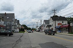
North Uxbridge, Business District
USA Massachusetts location map.svg
Red pog.svg
North Uxbridge
Location within the state of Massachusetts
Coordinates: 42°05′15″N71°38′28″W / 42.08750°N 71.64111°W / 42.08750; -71.64111
Country United States
State Massachusetts
County Worcester
Elevation
266 ft (81 m)
Time zone UTC-5 (Eastern (EST))
  Summer (DST) UTC-4 (EDT)
ZIP codes
01538
GNIS feature ID611038 [1]

North Uxbridge is a village and a post office in the town (township) of Uxbridge in Worcester County, Massachusetts, United States. The postal zip code is 01538. It is classified as a community or populated place (Class Code U6) located at latitude 42.088 and longitude -71.641 and the elevation is 266 feet (81 m). North Uxbridge appears on the Uxbridge U.S. Geological Survey Map. Worcester County is in the Eastern time zone (GMT -5) and observes DST. North Uxbridge is located approximately 36 miles west-southwest of Boston, and 15 miles southeast of Worcester. The town meeting in 1885 set aside North Uxbridge as a "special district", since its population had exceeded 1000 people. [2] North Uxbridge appeared as a separate Census tract in the 1960 census, with a population of 1882. [3] In 2013, an Uxbridge DIY show, The Garage, with Steve Butler, went worldwide from Steve's garage in North Uxbridge. [4]

Contents

Description of the village

North Uxbridge, the main northern village of the town, is also known as the "north end". The village receives municipal services from Uxbridge, for fire, police, emergency medical services, school district, public works, and other services. Worcester's Judicial District includes Uxbridge District Court. There is a North Uxbridge fire station Number 2, of the Uxbridge Fire Department. The commercial district includes a CVS pharmacy, small shops, businesses and restaurants. The Cornerstone Church (the former North Uxbridge Baptist Church [5] ) is a well known icon in the downtown area of the village. The village is no longer recognized as a separate census-designated place but is considered part of Uxbridge by the US Census bureau. Major employers include the local school district, and a commercial plastics manufacturing company in the former Rivulet mill. Residential construction has grown substantially in the last 20 years. The former North Uxbridge elementary school was also the Virginia Blanchard Pre-K Center, and is a historic building.

Historic features

The village is home to the historic Rogerson Village built by Robert Rogerson in the 1820s. [6] This village contains the Crown and Eagle Mills, considered an architectural masterpiece of an early New England mill village with worker housing and a water-powered cotton mill. [6] This system of water-powered mills, driven by dams, with spillways, and surrounded by mill villages, became known as "The Rhode Island System". North Uxbridge had other historic mills such as the Rivulet Mill and Richard Sayles Mills, originally built by Chandler Taft in 1814, and the Clapp Mill (1810). [6] Blanchard School and a number of other historic sites here such as Samuel Taft House, and the A. Whipple House, are listed on the Federal Register of historic places. It was also home to the Blanchard Granite quarry from which was mined large quantities of granite known throughout the Eastern United States. [6] Blanchard's quarry supplied Boston's reconstruction after its 1872 fire and sold New York City its curbstones. [6] [7] [8] The North Uxbridge School, or Virginia A. Blanchard School, is on the register of Historic Places (see also below), as is the Rogerson's Village. The village is part of the Blackstone River Valley National Heritage Corridor of Massachusetts and Rhode Island which is part of the National Park Service. The Blackstone River Valley is the oldest industrialized region in the United States. North Uxbridge borders Linwood and Northbridge. Mendon is to the East. Douglas is to the west. French Canadian Linwood's cotton mill and Robert Rogerson' masterpiece Crown and Eagle Cotton Mill were near Italian North Uxbridge's Rivulet Mill. [6]

Recent history

In the late 20th century, the former James Whitin Estate, also known as "GrayRock", served as an exclusive substance abuse treatment facility. Famous individuals receiving treatment included Joan Kennedy (the first wife of the late US Massachusetts Senator Ted Kennedy), and actress Amanda Blake, (who played Miss Kitty, on Gunsmoke ). This estate burned in a major fire a few years later and is today the location of Fire Station Number 2, of the Uxbridge Fire Department.

Government

See Uxbridge for Local Government Town website uxbridge-ma.gov

State government
State Representative(s): Ryan Fattman (R)
Kevin Kuros (R)
State Senator(s): Richard T. Moore (D)
Governor's Councilor(s):Jen Caissie (R)
Federal government
U.S. Representative(s): Richard E. Neal (D-2nd Dist.)
U.S. Senators: Elizabeth Warren (D), Ed Markey (D)

Industrial era photos

See also

Related Research Articles

<span class="mw-page-title-main">Mendon, Massachusetts</span> Town in Massachusetts, United States

Mendon is a town in Worcester County, Massachusetts, United States. The population was 6,228 at the 2020 census. Mendon is part of the Blackstone River Valley National Heritage Corridor, an early center of the industrial revolution in the United States. Mendon celebrated its 350th anniversary on May 15, 2017.

<span class="mw-page-title-main">Northbridge, Massachusetts</span> Town in Massachusetts, United States

Northbridge is a town in Worcester County, Massachusetts, United States. The population was 16,335 at the 2020 census. The Northbridge Town Hall is located at 7 Main Street in Whitinsville. The town is now a part of the Blackstone River Valley National Heritage Corridor, of the National Park Service. Northbridge claims to history include: Native American Nipmuc lands, Colonel John Spring, who led the Uxbridge militia training company in the American Revolution, Samuel Spring, Revolutionary War Chaplain, the Residence of Ezra T. Benson 1830–1832, the birthplace of President Millard Fillmore's mother, Phoebe, and home to the Whitin Machine Works from 1831 to 1964.

<span class="mw-page-title-main">Uxbridge, Massachusetts</span> Town in Massachusetts, United States

Uxbridge is a town in Worcester County, Massachusetts, United States, first colonized in 1662 and incorporated in 1727. It was originally part of the town of Mendon, and named for the Earl of Uxbridge. The town is located 36 mi (58 km) southwest of Boston and 15 mi (24 km) south-southeast of Worcester, at the midpoint of the Blackstone Valley National Historic Park. The historical society notes that Uxbridge is the "Heart of The Blackstone Valley" and is also known as "the Cradle of the Industrial Revolution". Uxbridge was a prominent Textile center in the American Industrial Revolution. Two Quakers served as national leaders in the American anti-slavery movement. Uxbridge "weaves a tapestry of early America".

<span class="mw-page-title-main">Whitinsville, Massachusetts</span> Census-designated place in Massachusetts, United States

Whitinsville is an unincorporated village within the town of Northbridge in Worcester County, Massachusetts, United States. Whitinsville is a census-designated place (CDP) and its population was 6,750 at the 2020 census. Whitinsville is pronounced as if it were spelled "White-ins-ville". It was founded by the Whitin family, after whom it is also named. It is a post office jurisdiction, with a ZIP Code of 01588. It is located on the Mumford River, a tributary of the Blackstone River.

<span class="mw-page-title-main">Massachusetts Route 146</span> State highway in Worcester County, Massachusetts, US

Route 146 is a 20.99-mile (33.78 km) north-south expressway in the U.S. state of Massachusetts, maintained by the Massachusetts Department of Transportation (MassDOT). Spanning approximately 21 miles (34 km) along a south–north axis, it is a continuation of Route 146 in Rhode Island, which splits from I-95 in Providence. The southern terminus within Massachusetts exists in Millville, where the expressway enters the state from North Smithfield, Rhode Island. Among several local roads, Route 146 intersects with the Massachusetts Turnpike (I-90) in Millbury and I-290 in Worcester before arriving at its northern terminus at the intersection of several surface streets in downtown Worcester. Most of the route is a freeway, except for a short section near the boundary between Millbury and Sutton where there is driveway access and at-grade crossings.

<span class="mw-page-title-main">Mumford River</span>

The Mumford River is an 18.3-mile-long (29.5 km) river in south-central Massachusetts. It is a tributary of the Blackstone River.

<span class="mw-page-title-main">Daniel Day (manufacturer)</span>

Daniel Day was an American pioneer in woolen manufacturing.

<span class="mw-page-title-main">Robert Rogerson</span> American businessman

Robert Rogerson was an early American industrialist. He was born in Taunton, Massachusetts, and died in the United States.

Luke Taft was an industrial pioneer in the manufacture of woolens in 19th century New England.

<span class="mw-page-title-main">Moses Taft</span> American politician

Moses Taft 2nd was born at Uxbridge, Massachusetts. He was significant as an early American Industrialist and financier in the historic Blackstone Valley, and a member of the famous Taft family.

<span class="mw-page-title-main">Linwood, Massachusetts</span> Village in Massachusetts, United States

Linwood is a village with its own post office in the towns of Northbridge and Uxbridge, Massachusetts, United States.

<span class="mw-page-title-main">Wheelockville, Massachusetts</span> Village in Massachusetts, United States

Wheelockville is a village in the town (township) of Uxbridge, Massachusetts, United States. Part of the village centering on Mendon and Henry streets is listed on the National Register of Historic Places as the Wheelockville Historic District. Wheelockville appears on the Blackstone U.S. Geological Survey Map. The Village receives municipal services from Uxbridge, for fire, police, EMS, School district, public works, and other services. Worcester's Judicial District includes Uxbridge District Court. The geography of Wheelockville includes several other distinct mill villages, including: Hecla and Elmdale.

<span class="mw-page-title-main">Rogerson's Village Historic District</span> Historic district in Massachusetts, United States

Rogersons Village Historic District is a historic mill village in Uxbridge, Massachusetts, United States.

The Taft family is an American political family of English and Irish descent, with origins in Massachusetts. Its members have served in the states of Massachusetts, Ohio, Rhode Island, Utah, and Vermont, and the United States federal government, in various positions such as representative (two), governor of Ohio, governor of Rhode Island, senator (three), secretary of agriculture, attorney general, secretary of war (two), acting secretary of defense, president, and chief justice.

<span class="mw-page-title-main">Rockdale Common Housing District</span> Historic district in Massachusetts, United States

The Rockdale Common Housing District is a historic district at 4–20 McBride, 46–58 Plantation, and 37–42 Taft Sts. in Northbridge, Massachusetts, United States. The district is composed of a collection of tenement houses built from c. 1880 to 1920. They were built by members of the Whitin family, who owned most of the textile production capacity in Northbridge. The district was added to the National Register of Historic Places in 1983.

The history of Uxbridge, Massachusetts, founded in 1727, may be divided into its prehistory, its colonial history and its modern industrial history. Uxbridge is located on the Massachusetts-Rhode Island state line, and became a center of the earliest industrialized region in the United States.

Jeremiah Wheelock was an American early industrial pioneer in the Blackstone Valley of Massachusetts, a region that incubated the early American industrial revolution.

References

  1. "North Uxbridge, Massachusetts". Geographic Names Information System . United States Geological Survey, United States Department of the Interior . Retrieved October 31, 2019.
  2. (source: Mae Wrona, Uxbridge, Images of America, Arcadia Press, 2000.)
  3. Census 1960
  4. Uxbridge DIY Show goes worldwide from Steve Butlers Garage, November 23, 3013, WCVB Boston
  5. "Name Change Press Release". July 7, 2017. Retrieved October 31, 2019.
  6. 1 2 3 4 5 6 "Walking tours - Uxbridge". Blackstone Daily. Archived from the original on November 1, 2006. Retrieved September 23, 2007.{{cite web}}: CS1 maint: unfit URL (link)
  7. "MHC Reconnaissance Survey Town Report: Uxbridge; Report Date: 1984 Associated Regional Report: Central Massachusetts;" (PDF). Massachusetts Historical Commission. 1984. Archived from the original (PDF) on December 2, 2007. Retrieved November 20, 2007.
  8. Crane, Ellery Bicknell (1907). Historic Homes and Institutions and Genealogical and Personal Memories of Worcester County, Massachusetts with a history of Worcester Society of Antiquity;. Chicago and New York: Lewis. p. 385.