North Smithfield, Rhode Island

Last updated

North Smithfield, Rhode Island
Forestdale school in Rhode Island.jpg
Forestdale school house from the nineteenth century
North Smithfield, RI Seal.png
North Smithfield, RI.png
Providence County Rhode Island incorporated and unincorporated areas North Smithfield highlighted.svg
Location in Providence County and the state of Rhode Island.
Coordinates: 41°59′17″N71°33′7″W / 41.98806°N 71.55194°W / 41.98806; -71.55194
Country United States
State Rhode Island
County Providence
Government
  Town AdministratorKimberly Alves
  Town CouncilClaire O’Hara
John Beauregard
Douglas Osier Jr.
Paulette Hamilton
Area
  Total24.7 sq mi (64.1 km2)
  Land24.0 sq mi (62.3 km2)
  Water0.7 sq mi (1.8 km2)
Elevation
[1]
387 ft (118 m)
Population
 (2020)
  Total12,558
  Density522/sq mi (201.6/km2)
Time zone UTC-5 (Eastern (EST))
  Summer (DST) UTC-4 (EDT)
ZIP codes
02824, 02896
Area code 401
FIPS code 44-52480 [2]
GNIS feature ID1219815 [1]
Website www.nsmithfieldri.org

North Smithfield is a town in Providence County, Rhode Island, United States, settled as a farming community in 1666 and incorporated into its present form in 1871. North Smithfield includes the historic villages of Forestdale, Primrose, Waterford, Branch Village, Union Village, Park Square, and Slatersville. The population was 12,588 at the 2020 census.

Contents

Geography

According to the United States Census Bureau, the town has a total area of 24.7 square miles (64 km2), of which 24.0 square miles (62 km2) is land and 0.7 square miles (1.8 km2) (2.83%) is water. North Smithfield is in a New England upland region. The Branch River and Blackstone Rivers provided much of the power for the early mills in the town. The town consists mainly of temperate forests, with minor elevation changes. At 586 ft (179 m), Woonsocket Hill in North Smithfield is one of the highest points in Rhode Island. Residents can expect mild summers and harsh winters.

History

In the 17th century British colonists settled in North Smithfield developing a farming community that they named after Smithfield, London in England. [3] The town was part of Smithfield, Rhode Island until it was incorporated as North Smithfield in 1871. [3] The first colonization occurred after a Native American, "William Minnian" (also known as "Quashawannamut") a Praying Indian [4] from Punkkupage Massachusetts Bay, on May 14, 1666, and again in 1669 with the permission of King Philip, [5] deeded approximately 2,000 acres" to John Mowry and Edward Inman who partnered with Nathaniel Mowry, John Steere, and Thomas Walling in dividing up the purchased tract. [3] During King Philip's War in 1676 Connecticut militia forces killed the last Narragansett sachem, Queen Quaiapen, and Stonewall John in Mattity Swamp in what is now North Smithfield in the Second Battle of Nipsachuck. In the early 18th century, a Quaker colony developed in what is now North Smithfield (then Smithfield), which extended into south Uxbridge, Massachusetts.

Today North Smithfield is part of the John H. Chaffee Blackstone River Valley National Heritage Corridor. The Blackstone Valley is the oldest industrialized region in the U.S. A local North Smithfield industry today, Berroco Yarns, is a continuation of an original family owned woolen company first established in this valley by Daniel Day in 1809.

A rare "stone-ender" known as the John Mowry Jr. or Sayles House on Wesquadomeset (Sayles) Hill near Iron Mine Hill and Sayles Hill Roads in North Smithfield, demolished in the 20th century Mowry home.JPG
A rare "stone-ender" known as the John Mowry Jr. or Sayles House on Wesquadomeset (Sayles) Hill near Iron Mine Hill and Sayles Hill Roads in North Smithfield, demolished in the 20th century

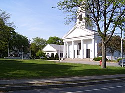
The village of Slatersville was largely built by Samuel Slater and his brother John Slater beginning in 1803. [6] It is a well-preserved original New England mill village with worker housing and commercial buildings and a church on a village green. This village is in fact America's first planned industrial mill village. [7] Samuel and John's family owned this mill and the village until the turn of the 20th century. [6]

Union Village, along Rhode Island Route 146A achieved local prominence as an important stagecoach stop on the route along Great Road. [7] Union Village was also home to a hat shop, taverns, an academy and the Union Bank from which the village got its name. [7] The North Smithfield Public Library was founded in 1931 with the first branch in the Union Village school. In 1965 Fogarty Hospital was constructed in the town.

In the nineteenth and early twentieth-century, North Smithfield "was served by several trolley and railroad lines; now all are gone save one. A freight-only spur line of the Providence and Worcester Railroad extends from the main line in Woonsocket and terminates [in Slatersville] at the Providence Pike" [8] where it "primarily serves a single customer, a steel supplier called Denman and Davis," [9] a company in Slatersville which is now part of O’Neal Steel, Inc. [10]

Demographics

Historical population
CensusPop.Note
1870 3,052
1880 3,0881.2%
1890 3,1732.8%
1900 2,422−23.7%
1910 2,69911.4%
1920 3,20018.6%
1930 3,94523.3%
1940 4,1966.4%
1950 5,72636.5%
1960 7,63233.3%
1970 9,34922.5%
1980 9,9726.7%
1990 10,4975.3%
2000 10,6181.2%
2010 11,96712.7%
2020 12,5885.2%
U.S. Decennial Census [11] [12]

As of the census [2] of 2000, there were 10,618 people, 3,954 households, and 2,957 families residing in the town. The population density was 441.7 inhabitants per square mile (170.5/km2). There were 4,070 housing units at an average density of 169.3 per square mile (65.4/km2). The racial makeup of the town was 98.32% White, 0.42% African American, 0.21% Native American, 0.52% Asian, 0.08% from other races, and 0.45% from two or more races. Hispanic or Latino people of any race were 0.47% of the population. 41% reported either French or French Canadian ancestry, 12% Irish, 12% Italian, and 8% English. [13]

Masjid Al Islam mosque on Sayles Hill Road in North Smithfield Mosque North Smithfield RI.jpg
Masjid Al Islam mosque on Sayles Hill Road in North Smithfield

There were 3,954 households, out of which 31.0% had children under the age of 18 living with them, 64.0% were married couples living together, 7.8% had a female householder with no husband present, and 25.2% were non-families. 21.3% of all households were made up of individuals, and 12.4% had someone living alone who was 65 years of age or older. The average household size was 2.61 and the average family size was 3.05.

In the town, the population was spread out, with 22.4% under the age of 18, 5.7% from 18 to 24, 27.2% from 25 to 44, 26.8% from 45 to 64, and 18.0% who were 65 years of age or older. The median age was 42 years. For every 100 females, there were 90.4 males. For every 100 females age 18 and over, there were 86.8 males.

The median income for a household in the town was $58,602, and the median income for a family was $67,331. Males had a median income of $43,133 versus $30,748 for females. The per capita income for the town was $25,031. About 1.9% of families and 3.5% of the population were below the poverty line, including 2.8% of those under age 18 and 9.9% of those age 65 or over.

Historic places in North Smithfield

The Peleg Arnold Tavern, built around 1690, was home to Peleg Arnold. Peleg Arnold tavern North Smithfield RI.JPG
The Peleg Arnold Tavern, built around 1690, was home to Peleg Arnold.

Notable people

Chief Justice Peleg Arnold was a resident of Union Village in North Smithfield. Judge Peleg Arnold by Arnold Steere 1815.jpg
Chief Justice Peleg Arnold was a resident of Union Village in North Smithfield.

Education

North Smithfield Middle School, opened in 2008-2009 North Smithfield Middle School 2017 Rhode Island.jpg
North Smithfield Middle School, opened in 2008–2009

The North Smithfield School District consists of four active schools:

Slatersville Green and the Congregational Church Slatersville Common and Church.jpg
Slatersville Green and the Congregational Church

Houses of worship

Related Research Articles

<span class="mw-page-title-main">Rhode Island</span> U.S. state

Rhode Island is a state in the New England region of the Northeastern United States. It is the smallest U.S. state by area and the seventh-least populous, with slightly fewer than 1.1 million residents as of 2020; but Rhode Island has grown at every decennial count since 1790 and is the second-most densely populated state, after New Jersey. The state takes its name from the eponymous island, though nearly all its land area is on the mainland. Rhode Island borders Connecticut to its west; Massachusetts to its north and east; and the Atlantic Ocean to its south via Rhode Island Sound and Block Island Sound; and shares a small maritime border with New York, east of Long Island. Providence is its capital and most populous city.

<span class="mw-page-title-main">Providence County, Rhode Island</span> County in Rhode Island, United States

Providence County is the most populous county in the U.S. state of Rhode Island. As of the 2020 census, the county's population was 660,741, or 60.2% of the state's population. Providence County contains the city of Providence, the state capital of Rhode Island and the county's most populous city, with an estimated 190,934 residents in 2020. Providence County is included in the Providence-Warwick, RI-MA Metropolitan Statistical Area, which in turn constitutes a portion of the greater Boston-Worcester-Providence, MA-RI-NH-CT Combined Statistical Area. As of 2010, the center of population in Rhode Island is located in Providence County, in the city of Cranston.

<span class="mw-page-title-main">Blackstone, Massachusetts</span> Town in Massachusetts, United States

Blackstone is a town in Worcester County, Massachusetts, United States. The population was 9,208 at the 2020 census. It is a part of the Providence metropolitan area.

<span class="mw-page-title-main">Central Falls, Rhode Island</span> City in Rhode Island, United States

Central Falls is a city in Providence County, Rhode Island, United States. The population was 22,583 at the 2020 census. With an area of only 1.29 square miles (3.3 km2), it is the smallest and most densely populated city in the smallest state, and the 27th most densely populated incorporated place in the United States. It is also one of only four incorporated places in New England that have a higher population density than the city of Boston. The city takes its name from a waterfall on the Blackstone River.

<span class="mw-page-title-main">Cumberland, Rhode Island</span> Town in Rhode Island, United States

Cumberland is the northeasternmost town in Providence County, Rhode Island, United States, first settled in 1635 and incorporated in 1746. The population was 36,405 at the 2020 census, making it the seventh-largest municipality and the largest town in the state.

<span class="mw-page-title-main">Lincoln, Rhode Island</span> Town in Rhode Island, United States

Lincoln is a town in Providence County, Rhode Island, United States. The population was 22,529 at the 2020 census. Lincoln is located in northeastern Rhode Island, north of Providence. Lincoln is part of the Providence metropolitan statistical area and the Greater Boston combined statistical area.

<span class="mw-page-title-main">Pawtucket, Rhode Island</span> City in Rhode Island

Pawtucket is a city in Providence County, Rhode Island. The population was 75,604 at the 2020 census, making the city the fourth-largest in the state. Pawtucket borders Providence and East Providence to the south, Central Falls and Lincoln to the north, and North Providence to the west. The city also borders the Massachusetts municipalities of Seekonk and Attleboro.

<span class="mw-page-title-main">Smithfield, Rhode Island</span> Town in Rhode Island, United States

Smithfield is a town that is located in Providence County, Rhode Island, United States. It includes the historic villages of Esmond, Georgiaville, Mountaindale, Hanton City, Stillwater and Greenville. The population was 22,118 at the 2020 census. Smithfield is the home of Bryant University, a private four year college.

<span class="mw-page-title-main">Woonsocket, Rhode Island</span> City in Rhode Island, United States

Woonsocket, is a city in Providence County, Rhode Island, United States. The population was 43,240 at the 2020 census, making it the sixth largest city in the state. Being Rhode Island's northernmost city, Woonsocket lies directly south of the Massachusetts state line and constitutes part of both the Providence metropolitan area and the larger Greater Boston Combined Statistical Area.

<span class="mw-page-title-main">North Kingstown, Rhode Island</span> Town in Rhode Island, United States

North Kingstown is a town in Washington County, Rhode Island, United States, and is part of the Providence metropolitan area. The population was 27,732 in the 2020 census. North Kingstown is home to the birthplace of American portraitist Gilbert Stuart, who was born in the village of Saunderstown. Within the town is Quonset Point, location of the former Naval Air Station Quonset Point, known for the invention of the Quonset hut, as well as the historic village of Wickford.

<span class="mw-page-title-main">North Providence, Rhode Island</span> Town in Rhode Island, United States

North Providence is a town in Providence County, Rhode Island, United States. The population was 34,114 at the 2020 census.

<span class="mw-page-title-main">Rhode Island Route 102</span> State highway in Rhode Island, US

Route 102 is a 44.4-mile-long (71.5 km) numbered state highway in the U.S. state of Rhode Island. Route 102 serves as a non-freeway beltway around the Providence metro area. It begins in the village of Wickford and travels through less developed areas of western Rhode Island. The route ends in the village of Slatersville.

<span class="mw-page-title-main">Thomas Alexander Tefft</span> American architect

Thomas Alexander Tefft was an American architect, from Providence, Rhode Island. Tefft, one of the nation's first professionally trained architects, is considered a master of Rundbogenstil and a leading American proponent of its use. Prior to his untimely death, Tefft "offered the most advanced designs of [his] day in America"

<span class="mw-page-title-main">Branch River (Rhode Island)</span> River in Rhode Island, United States

The Branch River is a river in the U.S. state of Rhode Island. It flows for approximately 16 km (10 mi). There are six dams along the river's length, including those forming the Slatersville Reservoir. The river provided energy for many of the region's textile mills in the nineteenth century.

<span class="mw-page-title-main">John Slater (industrialist)</span>

John Slater was an early American industrialist, founder of Slatersville, Rhode Island and younger brother of Samuel Slater, father of the American Industrial Revolution, and a member of the well-known Slater family.

<span class="mw-page-title-main">Slatersville, Rhode Island</span> Village in North Smithfield, Rhode Island, US

Slatersville is a village on the Branch River in the town of North Smithfield, Rhode Island, United States. It includes the Slatersville Historic District, a historic district listed on the National Register of Historic Places. The historic district has been included as part of the Blackstone River Valley National Historical Park. The North Smithfield Public Library is located in Slatersville.

<span class="mw-page-title-main">Walter F. Fontaine</span> American architect

Walter F. Fontaine was an American architect of French Heritage from Woonsocket, Rhode Island.

The Stillwater Mill was a former textile factory located in Smithfield, Rhode Island.

<span class="mw-page-title-main">Blackstone River Valley National Historical Park</span> National Park Service unit in Rhode Island and Massachusetts, United States

Blackstone River Valley National Historical Park is a National Park Service unit in the states of Rhode Island and Massachusetts. The park was created for the purpose of preserving, protecting, and interpreting the industrial heritage of the Blackstone River Valley and the urban, rural, and agricultural landscape of that region. The Blackstone River Valley was the site of some of the earliest successful textile mills in the United States, and these mills contributed significantly to the earliest American Industrial Revolution. The subsequent construction of the Blackstone Canal, a few years after the successful completion of the Erie Canal, helped to sustain the region's industrial strength.

References

  1. 1 2 U.S. Geological Survey Geographic Names Information System: North Smithfield, Rhode Island
  2. 1 2 "U.S. Census website". United States Census Bureau . Retrieved January 31, 2008.
  3. 1 2 3 Nebiker, Walter (1976). the History of North Smithfield. Somersworth, NH: New England History Press.
  4. The Narragansett Historical Register: A Magazine Devoted to the Antiquities, Genealogy and Historical Matter Illustrating the History of the State of Rhode Island and Providence Plantations. Narragansett Historical Publishing Company. 1888.
  5. The Providence Plantations for Two Hundred and Fifty Years: An Historical ...By Welcome Arnold Greene, pg 394
  6. 1 2 "Samuel Slater/The Mill Village, Slatersville/Woonsocket". Woonsocket.org. Retrieved December 26, 2007.
  7. 1 2 3 "Plan your visit/Valley sites/Cumberland, North Smithfield, Smithfield". National Park Service. Retrieved December 25, 2007.
  8. North Smithfield Comprehensive Plan Five-Year Update Revised August 2007 J - Circulation –March 2006 "Archived copy" (PDF). Archived from the original (PDF) on August 1, 2013. Retrieved January 15, 2013.{{cite web}}: CS1 maint: archived copy as title (link)
  9. Frank Heppner, Railroads of Rhode Island: Shaping the Ocean State's Railways (The History Press, 2012) pg. 81
  10. "121-Year-Old Metals Service Center Gets New Identity » O'Neal Industries". onealind.com. September 2, 2010. Retrieved April 9, 2018.
  11. "Census of Population and Housing". Census.gov. Retrieved June 4, 2016.
  12. Snow, Edwin M. (1867). Report upon the Census of Rhode Island 1865. Providence, RI: Providence Press Company.
  13. "North Smithfield - North Smithfield - Ancestry & family history - ePodunk". www.epodunk.com. Archived from the original on April 2, 2015. Retrieved April 9, 2018.
  14. Who Was Who in America, Historical Volume, 1607-1896. Chicago: Marquis Who's Who. 1963.
  15. "RootsWeb.com Home Page". www.rootsweb.ancestry.com. Retrieved April 9, 2018.
  16. "Obituary Record of Graduates of Yale University Deceased during the Year 1930-1931" (PDF). Bulletin of Yale University. December 1, 1931.
  17. Wilkinson, Alec (September 20, 2004). "The Ghostly Ones". The New Yorker . p. 78. Retrieved May 3, 2009.
  18. "Ranking of High Schools in Rhode Island". www.psk12.com. Archived from the original on March 9, 2015. Retrieved April 9, 2018.
  19. "Lighthouse Christian Church - North Smithfield, RI". www.lfwc.org. Retrieved April 9, 2018.
  20. Masjid Al-Islam mosque Archived 2011-09-17 at the Wayback Machine
  21. "Home". Slatersville Congregational Church-UCC. Retrieved April 9, 2018.
  22. "ST. JOHN THE EVANGELIST, SLATERSVILLE RI". www.stjohnslatersville.4lpi.com. Archived from the original on March 10, 2012. Retrieved April 9, 2018.

41°58′00″N71°32′58″W / 41.96667°N 71.54944°W / 41.96667; -71.54944