Foster is a town in Providence County, Rhode Island, in the United States. The population was 4,469 at the 2020 census.

Scituate is a town in Providence County, Rhode Island, United States. The population was 10,384 at the 2020 census.

Old Mission is an unincorporated community in Grand Traverse County in the U.S. state of Michigan. The community is located within Peninsula Township, and is located about 2 miles (3.2 km) south of the tip of the Old Mission Peninsula, along the shore of the East Arm of Grand Traverse Bay. As an unincorporated community, Old Mission has no legally defined boundaries or population statistics of its own.

Wakefield is a village in the town of South Kingstown, Rhode Island, United States, and the commercial center of South Kingstown. Together with the village of Peace Dale, it is treated by the U.S. Census as a component of the census-designated place identified as Wakefield-Peacedale. West Kingston, another South Kingstown village, was the traditional county seat of Washington County. Since 1991, the Washington County Courthouse has been in Wakefield. The Sheriff's Office which handles corrections is also in Wakefield.

Peace Dale is a village in the town of South Kingstown, Rhode Island, United States. Together with the village of Wakefield, it is treated by the U.S. Census as a component of the census-designated place identified as Wakefield-Peacedale.

Plantsville is a neighborhood in the town of Southington, Hartford County, Connecticut, United States. It is centered at the merger between South Main Street and West Main Street. As of the 2000 Census there were 10,387 people living in the Zip Code Tabulation Area for zip code 06479, which is assigned the postal city name Plantsville. The Zip Code Tabulation Area includes the entire southwestern corner of the town of Southington, including Marion and Milldale. Beginning in 2015 Plantsville was listed as a census-designated place.

Wickford is a small village in the town of North Kingstown, Rhode Island, United States, which is named after Wickford in Essex, England. Wickford is located on the western side of Narragansett Bay, just about a 20-minute drive across two bridges from Newport, Rhode Island. The village is built around one of the most well-protected natural harbors on the eastern seaboard, and features one of the largest collections of 18th century dwellings to be found anywhere in the Northeast. Today, the majority of the village's historic homes and buildings remain largely intact upon their original foundations.

Saunderstown is a small village and historic district in the towns of Narragansett and North Kingstown in Washington County, Rhode Island, United States. It was named in honor of John Aldrich Saunders, a member of the Saunders family. Saunderstown has its own post office with the ZIP Code of 02874, which also includes a small part of South Kingstown. Its population is 6,245.

The Smithville Seminary was a Freewill Baptist institution established in 1839 at the location of the modern Institute Lane in Smithville-North Scituate, Rhode Island. Renamed the Lapham Institute in 1863, it closed in 1876. The site was then used as the campus of the Pentecostal Collegiate Institute, later the Watchman Institute, and then became the Scituate Commons apartments. It was placed on the National Register of Historic Places in 1978.
The Watchman Industrial School and Camp, also known as the Watchman Institute, was founded in 1908 for black youths by Reverend William S. Holland in Providence, Rhode Island. He based it on the educational theories of Booker T. Washington. In 1923, Holland moved the school to North Scituate when he acquired the property of the Pentecostal Collegiate Institute. He closed the school in 1938 during the Great Depression, when many private schools were unable to survive financially.

Russell Warren (1783–1860) was an American architect, best known for his work in the Greek Revival style. He practiced in Bristol and Providence.

Slatersville is a village on the Branch River in the town of North Smithfield, Rhode Island, United States. It includes the Slatersville Historic District, a historic district listed on the National Register of Historic Places. The historic district has been included as part of the Blackstone River Valley National Historical Park. The North Smithfield Public Library is located in Slatersville.

North Uxbridge is a village and a post office in the town (township) of Uxbridge in Worcester County, Massachusetts, United States. The postal zip code is 01538. It is classified as a community or populated place located at latitude 42.088 and longitude -71.641 and the elevation is 266 feet (81 m). North Uxbridge appears on the Uxbridge U.S. Geological Survey Map. Worcester County is in the Eastern time zone and observes DST. North Uxbridge is located approximately 36 miles west-southwest of Boston, and 15 miles southeast of Worcester. The town meeting in 1885 set aside North Uxbridge as a "special district", since its population had exceeded 1000 people. North Uxbridge appeared as a separate Census tract in the 1960 census, with a population of 1882. In 2013, an Uxbridge DIY show, The Garage, with Steve Butler, went worldwide from Steve's garage in North Uxbridge.

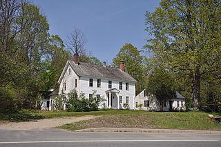
The Old Congregational Church is an historic church building on Greenville Road in the Smithville-North Scituate village of Scituate, Rhode Island. The wood-frame shingled church was designed by Clark Sayles and complete in 1831. The church was regularly used in the 19th century, but attendance declined in the later years, and it was only occasional used until 1940, when it was given to the town. In 1974, the building was listed on National Register of Historic Places.

The Little Compton Commons Historic District, or Little Compton Commons, is a historic district in Little Compton, Rhode Island. It is a triangular area roughly bounded by School House Lane to the north, South Commons Road to the east, and Meeting House Lane to the south. Properties continue to the west on West Road.
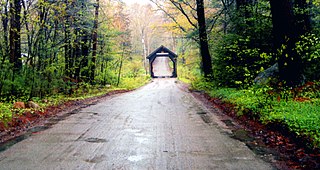
Clayville Historic District is an 81-acre (33 ha) historic district in Foster and Scituate, Rhode Island. The district encompasses the heart of the village of Clayville, a small 19th-century mill village. It is centered on the junction of Plainfield Pike, Field Hill Road, and Victory Highway near the Clayville Mill pond, and is roughly bisected by the town line between Foster and Scituate. The mill pond is impounded by a c. 1847 dam, which powered mills whose ruins and waterways lie downstream. The village is mainly residential, with vernacular 19th-century construction predominating. Notable buildings include the Clayville Christian Union Church, built 1867–71 with Greek Revival styling, and the c. 1845 Clayville Schoolhouse.

The Hope Village Historic District is a historic rural mill settlement within Hope Village in Scituate, Rhode Island. Hope Village is located on a bend in the North Pawtuxet River in the southeastern corner of Scituate. Industrial activity has occurred in Hope Village since the mid-eighteenth century. Surviving industrial and residential buildings in the Historic District date back to the early 19th century. The village center sits at junction of Main Street and North Road. Hope Village radiates out from the center with houses on several smaller side streets in a compact configuration. Currently there is little commercial or industrial activity in Hope Village and none in the Historic District. The present stone mill building on the south side of Hope Village was built in 1844 by Brown & Ives of Providence, expanded in 1871 and modified in 1910. Approximately one quarter of the village's current housing stock was built as mill worker housing by various owners of Hope Mill.

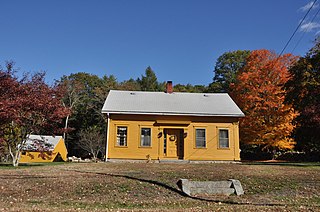
The Pentecostal Collegiate Institute was a co-educational interdenominational collegiate institute located at North Scituate, Rhode Island from September 1902 to 1918. PCI was incorporated in Rhode Island and operated by its own board in association with the Association of Pentecostal Churches of America. The Church of the Nazarene operated it after 1915. It is considered a predecessor to Eastern Nazarene College.

Stephen Carpenter Earle was an architect who designed a number of buildings in Massachusetts and Connecticut that were built in the late 19th century, with many in Worcester, Massachusetts. He trained in the office of Calvert Vaux in New York City. He worked for a time in partnership with James E. Fuller, under the firm "Earle & Fuller". In 1891, he formed a partnership with Vermont architect Clellan W. Fisher under the name "Earle & Fisher".
West Townshend is an unincorporated village in Townshend, Vermont, United States. It is on the north side of a bend in the West River, upriver of the Townshend Dam. The entire village is listed on the National Register of Historic Places as the West Townshend Village Historic District. Its ZIP codes are 05359 and 05353.


 Old Congregational Church, built in 1834
 Pentecostal Collegiate Institute on the site of the former Smithville Seminary built in 1839

