Cumberland is the northeasternmost town in Providence County, Rhode Island, United States, first settled in 1635 and incorporated in 1746. The population was 36,405 at the 2020 census, making it the seventh-largest municipality and the largest town in the state.

North Smithfield is a town in Providence County, Rhode Island, United States, settled as a farming community in 1666 and incorporated into its present form in 1871. North Smithfield includes the historic villages of Forestdale, Primrose, Waterford, Branch Village, Union Village, Park Square, and Slatersville. The population was 12,588 at the 2020 census.

The Blackstone Valley or Blackstone River Valley is a region of Massachusetts and Rhode Island. It was a major factor in the American Industrial Revolution. It makes up part of the Blackstone River Valley National Heritage Corridor and National Historical Park.

Union Station describes two distinct, defunct train stations in Providence, Rhode Island. Parts of the latter one were renovated and the building contains offices and restaurants.

Cannelton Cotton Mill, also known as Indiana Cotton Mill, is a National Historic Landmark of the United States located in Cannelton, Indiana, United States. Built in 1849 as an effort to expand textile milling out of New England, it was the largest industrial building west of the Allegheny Mountains, designed by Thomas Alexander Tefft, an early industrial architect. It was declared a National Historic Landmark in 1991. The building now houses residences.

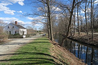
The Blackstone Canal was a manmade waterway, linking Worcester, Massachusetts, to Providence, Rhode Island, and Narragansett Bay, through the Blackstone Valley, via a series of locks and canals in the early 19th century. Construction started in 1825, and the canal opened three years later. After the opening of the Boston and Providence Railroad (1835), the canal struggled for business. Its transportation role was taken over by the Providence and Worcester Railroad, which completed a parallel line in 1847. The canal shut down in 1848. Several segments of the canal are preserved, and the canal alignment and remains are on the National Register of Historic Places.

The Slater Mill is a historic water-powered textile mill complex on the banks of the Blackstone River in Pawtucket, Rhode Island, modeled after cotton spinning mills first established in England. It is the first water-powered cotton spinning mill in America to utilize the Arkwright system of cotton spinning as developed by Richard Arkwright.
Abbott Run is a de facto river in the U.S. state of Massachusetts and Rhode Island. It flows approximately 10 miles (16 km).
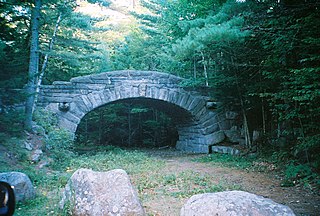
Acadia National Park, largely on Mount Desert Island, off the coast of the U.S. state of Maine, was created in part by land and other donations by John D. Rockefeller Jr. Between 1919 and 1931, Rockefeller, who was opposed to the introduction of automobiles on the island, personally oversaw the construction of a network of carriage roads, closed to motorized vehicles, on the eastern half of the island, including sixteen granite bridges and two gatehouses. The major portion of this network now falls within the bounds of the national park, and was listed on the National Register of Historic Places in 1979.
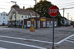
Lonsdale is a village and historic district in Lincoln and Cumberland, Providence County, Rhode Island, United States, near Rhode Island Route 146 and Route 95. The village was originally part of the town of Smithfield until Lincoln was created in the 1870s, and was originally centered on the Lincoln side of the Blackstone River. William Blaxton settled in the area in 1635. In the nineteenth and early twentieth centuries, Lonsdale was home to several manufacturers including the Lonsdale Company's Bleachery, and the Ann & Hope mill was also located in the village in Cumberland.

The Ashton Historic District is a historic district in Cumberland, Rhode Island. The district consists of a mill and an adjacent mill village that was built for the workers of the mill. It lies between Mendon Road, Scott Road, Angell Road, Store Hill Road, Front Street and Middle Street. The district was added to the National Register of Historic Places on November 1, 1984.

The Sassafras Site, designated RI-55, is a prehistoric archaeological site in Albion, a village of Lincoln, Rhode Island. The site was discovered by archaeologists while surveying an area for a potential replacement for the Albion Street bridge, which spans the Blackstone River between Lincoln and Cumberland. The site encompasses a regionally significant quartz stone tool workshop.

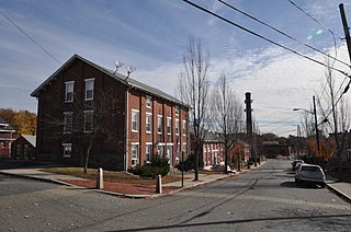
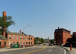
The Woonsocket Company Mill Complex is a historic district encompassing one of the largest mill complexes in Woonsocket, Rhode Island. The district includes all of the buildings historically associated with the Woonsocket Company, a major manufacturer of cotton textiles in the 19th century. The complex is located along the eastern bank of the Blackstone River between Court and Bernon Streets. It includes three handsome stone mills, built between 1827 and 1859, and a power plant that was built on the site of the former #3 mill between 1890 and 1920, as well as the remnants of the canal that originally carried water to the buildings for power.

The Ernest Street Sewage Pumping Station is an historic wastewater pumping station at Ernest and Ellis Streets near the wastewater treatment facility at Field's Point in Providence, Rhode Island. The surviving elements of the station include a main pumphouse and a smaller screening house, both built in 1897-98 as part of a major effort to modernize Providence's sewage treatment facilities. A third structure, a boiler house, was demolished in 1987, and a tall smokestack was taken down in the 1930s.
Moshassuck Square is an industrial historic district in Providence, Rhode Island, lining the banks of the Blackstone Canal just north of the Rhode Island State House. It consists of the few surviving buildings of the once-extensive American Screw Company complex, which was largely developed between the 1840s and 1870s, and was a major fixture in the Providence landscape prior to its destruction by fire in 1971. The buildings are in an area bounded by Charles Street on the west, Stevens and Hewes Streets on the north, North Main Street to the east, and Mill Street to the south. Prominent among them are the Stillman White Foundry and Fletcher Manufacturing Company office building, which stand on opposite sides of Mill Street near its crossing of the canal. At 127 Charles Street stands a three-story brick building built c. 1900 as a retail and residential building. The only surviving elements of the Screw Company complex are located at North Main and Hewes Streets, and now house the Providence Center.

The Valley Falls Company was founded in 1839 by Oliver Chace, in Valley Falls, Rhode Island, a historic mill village on both sides of the Blackstone River, within the modern-day town of Cumberland and city of Central Falls, Rhode Island. The Valley Falls Company is the original antecedent of Berkshire Hathaway, currently one of the world's largest and most successful companies.
Quinnville is a village incorporated into the Town of Lincoln, Rhode Island, United States. It is the smallest of the seven villages within Lincoln, bordered by the villages of Albion at the north, Limerock to the west, Lonsdale to the south, and by the Blackstone River to the east.

The Fremont Mill Bridge near Anamosa, Iowa was built in 1873. Its superstructure was designed and built by Massillon Iron Bridge Company and its foundations were built by James Milne. It is a wrought iron bowstring through arch bridge.

The Yosemite Valley Bridges are eight bridges in the Yosemite Valley of Yosemite National Park, most of them spanning the Merced River. Five of them were built in 1928, with the remainder built between 1921 and 1933. The bridges feature a concrete structure faced with local stone, in an elliptical or three-centred arch configuration. They are notable for their uniform character and for their conformance to tenets of the National Park Service rustic style. Design work for the seven newer bridges was by George D. Whittle of the San Francisco District Office of the U.S. Bureau of Public Roads for the National Park Service. Concrete bridges were chosen at the urging of Thomas Chalmers Vint of the Park Service, in lieu of alternative designs for steel truss bridges, or suspension bridges suggested by the park superintendent.

The Blackstone Park Conservation District is a public, 45-acre woodland conservation area on the East Side of Providence, Rhode Island. It is run by the non-profit Blackstone Parks Conservancy in partnership with the Providence Parks Department. The park is situated on the west bank of the tidal Seekonk River, the northernmost part of Narragansett Bay tidewater. The park lies within the watershed and wildlife corridor of the Blackstone River Valley. Unlike many city parks, it is actively managed as a preserve for the purpose of providing habitats for wildlife and supporting a healthy ecosystem for native flora and fauna.