North Kingstown, Rhode Island

Last updated
North Kingstown, Rhode Island
Gilbert Stuart birthplace and barn.jpg
The Gilbert Stuart Birthplace in North Kingstown
Nickname: 
"NK"
N Kingstown RI lg.PNG
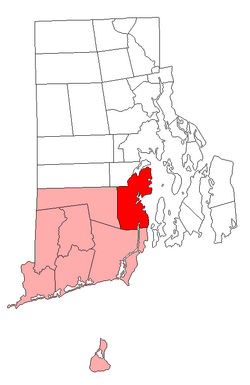
Location of North Kingstown in Washington County, Rhode Island
Coordinates: 41°34′50″N71°27′14″W / 41.58056°N 71.45389°W / 41.58056; -71.45389 Coordinates: 41°34′50″N71°27′14″W / 41.58056°N 71.45389°W / 41.58056; -71.45389
CountryUnited States
State Rhode Island
County Washington
Government
  Town CouncilGregory A. Mancini
Dr. Kimberly Ann Page
Katherine Anderson
Matthew B. McCoy
Lawrence C. Mandel
Area
  Total58.3 sq mi (151.1 km2)
  Land43.6 sq mi (112.9 km2)
  Water14.7 sq mi (38.2 km2)
Elevation
82 ft (25 m)
Population
 (2020)
  Total27,732
  Density636/sq mi (245.6/km2)
Time zone UTC−5 (Eastern (EST))
  Summer (DST) UTC−4 (EDT)
ZIP codes
02852 (North Kingstown), 02874 (Saunderstown), 02877 (Slocum)
Area code 401
FIPS code 44-51580 [1]
GNIS feature ID1220088 [2]
Website www.northkingstown.org

North Kingstown is a town in Washington County, Rhode Island, United States, and is part of the Providence metropolitan area. The population was 27,732 in the 2020 census. North Kingstown is home to the birthplace of American portraitist Gilbert Stuart, who was born in the village of Saunderstown. Within the town is Quonset Point, location of the former Naval Air Station Quonset Point, known for the invention of the Quonset hut, as well as the historic village of Wickford.

Contents

History

The area was first settled by Roger Williams and Richard Smith who set up trading posts near Wickford where Smith's Castle is today. The town of Kings Towne was founded in 1674, by the colonial government, and included the present day towns of North Kingstown, South Kingstown, Exeter, and Narragansett. In 1723, Kings Towne was split into two parts, North Kingstown and South Kingstown, with North Kingstown, having the earliest settlements, retaining the 1674 establishment date. In 1742, the town of Exeter was taken from the western part of North Kingstown.

Geography

According to the United States Census Bureau, the town has a total area of 58.3 square miles (151 km2), of which 43.6 square miles (113 km2) is land and 14.8 square miles (38 km2) (25.28%) is water.

Demographics

Historical population
CensusPop.
1790 2,907
1800 2,794−3.9%
1810 2,9575.8%
1820 3,0071.7%
1830 3,0361.0%
1840 2,909−4.2%
1850 2,9712.1%
1860 3,1044.5%
1870 3,56314.8%
1880 3,94910.8%
1890 4,1936.2%
1900 4,1940.0%
1910 4,048−3.5%
1920 3,397−16.1%
1930 4,27926.0%
1940 4,6047.6%
1950 14,180208.0%
1960 18,97733.8%
1970 29,79357.0%
1980 21,938−26.4%
1990 23,7868.4%
2000 26,32610.7%
2010 26,4860.6%
2020 27,7324.7%
U.S. Decennial Census [3] [4]

As of the 2010 census, [1] there were 26,486 people, 10,436 households, and 7,347 families residing in the town. The racial makeup of the town was 94.7% White, 1.0% African American, 0.6% American Indian/Alaska Native, 1.3% Asian, 0.5% from some other race other races, and 1.9% from two or more races. Hispanic or Latino of any race were 2.4% of the population.

Of the 10,436 households, 70.4% were families, 31.2% had children under the age of 18 living with them, and 29.6% were non-families. 24.2% of all households were made up of householders living alone. The average household size was 2.52 and the average family size was 3.02. 75.4% of households resided in owner-occupied units and 24.6% in rental units.

According to the 2017 American Community Survey, the median income for a household in the town was $87,311 (adjusted to inflation), the median income for a family was $105,954, and the median income for married-couple families was $120,103. [5]

Transportation

Wickford Junction is a terminus station on the Providence/Stoughton Line of the MBTA Commuter Rail, providing weekday train service to Providence Station and Boston's South Station.

RIPTA also services in the town inbound to Providence and outbound to Narragansett or Newport.

North Kingstown is also served by a passenger ferry connecting to the island of Martha's Vineyard. [6]

Education

North Kingstown School Department is the municipal school district. It operates North Kingstown High School.

Notable people

Points of interest

Other National Historic Places in North Kingstown

See also

Related Research Articles

<span class="mw-page-title-main">Rhode Island</span> U.S. state

Rhode Island is a state in the New England region of the Northeastern United States. It is the smallest U.S. state by area and the seventh-least populous, with slightly less than 1.1 million residents as of 2020, but it is the second-most densely populated after New Jersey. It takes its name from the eponymous island, though nearly all of its land area is on the mainland. Rhode Island borders Connecticut to the west; Massachusetts to the north and east; and the Atlantic Ocean to the south via Rhode Island Sound and Block Island Sound. It also shares a small maritime border with New York. Providence is its capital and most populous city.

<span class="mw-page-title-main">East Greenwich, Rhode Island</span> Town in Rhode Island, United States

East Greenwich is a town and the county seat of Kent County, Rhode Island. The population was 14,312 at the 2020 census. East Greenwich is the wealthiest municipality within the state of Rhode Island. It is part of the Providence metropolitan statistical area and the Greater Boston combined statistical area.

<span class="mw-page-title-main">Exeter, Rhode Island</span> Town in Rhode Island, United States

Exeter is a town in Washington County, Rhode Island, United States. Exeter extends east from the Connecticut border to the town of North Kingstown. It is bordered to the north by West Greenwich and East Greenwich, and to the south by Hopkinton, Richmond, and South Kingstown. Exeter's postal code is 02822, although small parts of the town have the mailing address West Kingston (02892) or Saunderstown (02874). The population was 6,460 at the 2020 census.

<span class="mw-page-title-main">Narragansett, Rhode Island</span> Town in Rhode Island, United States

Narragansett is a town in Washington County, Rhode Island, United States. The population was 14,532 at the 2020 census. However, during the summer months the town's population more than doubles to near 34,000. The town of Narragansett occupies a narrow strip of land running along the eastern bank of the Pettaquamscutt River to the shore of Narragansett Bay. It was separated from South Kingstown in 1888 and incorporated as a town in 1901.

<span class="mw-page-title-main">South Kingstown, Rhode Island</span> Town in Rhode Island, United States

South Kingstown is a town in, and the county seat of, Washington County, Rhode Island, United States. The population was 31,931 at the 2020 census. South Kingstown is the second largest town in Rhode Island by total geographic area, behind New Shoreham, and the third largest town in Rhode Island by geographic land area, behind Exeter and Coventry.

<span class="mw-page-title-main">Wakefield, Rhode Island</span> Village in Rhode Island, United States

Wakefield is a village in the town of South Kingstown, Rhode Island, United States, and the commercial center of South Kingstown. Together with the village of Peace Dale, it is treated by the U.S. Census as a component of the census-designated place identified as Wakefield-Peacedale, Rhode Island. West Kingston, another South Kingstown village, was the traditional county seat of Washington County. Since 1991, the Washington County Courthouse has been in Wakefield. The Sheriff's Office which handles corrections is also in Wakefield.

<span class="mw-page-title-main">Peace Dale, Rhode Island</span> United States historic place

Peace Dale is a village in the town of South Kingstown, Rhode Island. Together with the village of Wakefield, it is treated by the U.S. Census as a component of the census-designated place identified as Wakefield-Peacedale, Rhode Island.

<span class="mw-page-title-main">Rhode Island Route 1A</span> Highway in Rhode Island

Route 1A, largely signed as Scenic 1A, is a 33.3-mile (53.6 km) long numbered state highway located in Washington County, Rhode Island, United States. The route, which parallels U.S. Route 1 for its entire length, has four distinct sections connected by US 1, two of which require median u-turn ramps to cross US 1. It travels through five towns in Washington County: Westerly, Charlestown, South Kingstown, Narragansett, and North Kingstown.

<span class="mw-page-title-main">Rhode Island Route 4</span> Highway in Rhode Island

Route 4, also known as the Colonel Rodman Highway, is a 10.37-mile-long (16.69 km) numbered state highway located in Washington County and southern Kent County, Rhode Island, United States. The route is a major north–south freeway in the southern Providence metropolitan area, directly linking Providence with eastern Washington County, the beaches of Narragansett and South Kingstown, and the city of Newport. Route 4 begins as a two-lane divided highway at an intersection with U.S. Route 1 in the town of North Kingstown, becoming a limited-access freeway after 1.89 miles (3.04 km). The route has four numbered interchanges before terminating in the city of Warwick, where the northbound lanes merge into Interstate 95 (I-95).

<span class="mw-page-title-main">Wickford, Rhode Island</span> United States historic place

Wickford is a small village in the town of North Kingstown, Rhode Island, United States, which is named after Wickford in Essex, England. Wickford is located on the west side of Narragansett Bay, just about a 20-minute drive across two bridges from Newport, Rhode Island. The village is built around one of the most well-protected natural harbors on the eastern seaboard, and features one of the largest collections of 18th century dwellings to be found anywhere in the northeast. Today the majority of the village's historic homes and buildings remain largely intact upon their original foundations.

<span class="mw-page-title-main">Saunderstown, Rhode Island</span> United States historic place

Saunderstown is a small village and historic district in the towns of Narragansett and North Kingstown in Washington County, Rhode Island, United States. Saunderstown has its own post office with the ZIP Code of 02874, which also includes a small part of South Kingstown. Its population is 6,245.

<span class="mw-page-title-main">Davisville, Rhode Island</span> Human settlement in Rhode Island, United States of America

Davisville, Rhode Island is a village in the town of North Kingstown in the U.S. state of Rhode Island that was formerly the home of the Davisville Naval Construction Battalion Center, which housed the United States Navy's SeaBees.

<span class="mw-page-title-main">Fox Island (Rhode Island)</span>

Fox Island is an island in Narragansett Bay, Rhode Island, in the United States of America. It lies between Conanicut Island and North Kingstown just south of the village of Wickford, Rhode Island. The island is a part of the town of North Kingstown. The Native Americans called the island "Nanaquonset" The island was purchased from Native Americans by Randall Holden and Samuel Gorton in 1659. In the 1860s a Christian preacher named Captain Jimmie Hammond became the first full-time resident of the island where he lived with his chickens and cat. In 1880, Rev. William Pendleton Chapman, a pastor at the nearby Quidnessett Church, featured the island in his adventure book titled “Budd Boyd’s Triumph: The Boy Firm of Fox Island.” Various other private owners have owned the island since its first habitation. Since 2000 it has been privately owned by a corporation which uses a large wind generator on the east side of the island.

<span class="mw-page-title-main">Smith's Castle</span> Historic house in Rhode Island, United States

Smith's Castle, built in 1678, is a house museum at 55 Richard Smith Drive, near Wickford, a village in North Kingstown, Rhode Island, United States. Smith's Castle is one of the oldest houses in the state. It was designated a National Historic Landmark in 1993 as Cocumscussoc Archeological Site, due to the artifacts and information digs in the vicinity have yielded. It is located just off U.S. 1.

<span class="mw-page-title-main">Norman Isham</span> American architect

Norman Morrison Isham (1864–1943) was a prominent architectural historian, author, and professor at Brown University and RISD. He was an ardent preservationist and a pioneer in the study of early American architecture.

<span class="mw-page-title-main">Old Narragansett Church</span> Historic church in Rhode Island, United States

Old Narragansett Church is a historic Episcopal church located at 60 Church Lane in Wickford, Rhode Island, believed to be the oldest Episcopal church building in the Northeastern United States.

<span class="mw-page-title-main">St. Paul's Church (North Kingstown, Rhode Island)</span> Historic church in Rhode Island, United States

St. Paul's Church is a historic church at 55 Main Street in the village of Wickford within the town of North Kingstown, Rhode Island. It is a single-story Romanesque Revival structure, designed by Rhode Island architect Thomas Tefft and built in 1847. Its main rectangular block has a gable roof, and narrow round-arch windows on the side walls with molded surrounds. The front of the church is asymmetrical, with the tower on the left and its entry slightly off-center between the tower and a small projecting narthex area. The square tower has single narrow round-arch windows on the first level, paired round-arch windows on the second, and clock faces on the third. A roof skirt rises to an open octagonal belfry, which is capped by a steeple and spire.

<span class="mw-page-title-main">Washington County, Rhode Island</span> County in Rhode Island, United States

Washington County, known locally as South County, is a county located in the U.S. state of Rhode Island. As of the 2020 census, the population was 129,839. Rhode Island counties have no governmental functions other than as court administrative boundaries, which are part of the state government.

The Narragansett Runestone, also known as the Quidnessett Rock, is a 2.5 t (2,500 kg) slab of metasandstone located in Rhode Island, United States. It is inscribed with two rows of symbols, which some have indicated resemble ancient runic characters.

Peter Phillips was a justice of the Rhode Island Supreme Court from May 1780 to May 1786.

References

  1. 1 2 "U.S. Census website". United States Census Bureau . Retrieved 2008-01-31.
  2. "US Board on Geographic Names". United States Geological Survey. 2007-10-25. Retrieved 2008-01-31.
  3. "Census of Population and Housing". Census.gov. Retrieved June 4, 2016.
  4. Snow, Edwin M. (1867). Report upon the Census of Rhode Island 1865. Providence, RI: Providence Press Company.
  5. "U.S. Census website". United States Census Bureau . Retrieved 2020-03-10.
  6. "Martha's Vineyard Ferry". Rhode Island Fast Ferry.
  7. "Elizabeth Beisel". Olympic.org. Retrieved 12 April 2021.
  8. Updike, Wilkins (1907). A history of the Episcopal Church in Narragansett, Rhode Island: including a history of other Episcopal churches in the state. Vol. 1. Boston: Printed and published by D.B. Updike.
  9. Cannon, Angie (June 12, 1994). "Myers Gives White House A Different Kind Of Face -- Clinton's Young Press Chief Learns Fast Under Fire". The Seattle Times. Retrieved September 14, 2022.