Wakefield-Peacedale, Rhode Island

Last updated
Wakefield-Peacedale, Rhode Island
CDP
Peace Dale Congregational Church.JPG
Peace Dale Congregational Church
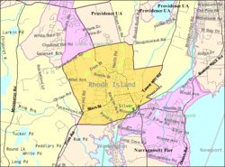
Detailed map of Wakefield-Peacedale, Rhode Island.png
Map of Wakefield-Peacedale with its boundaries in 2000
Coordinates: 41°26′28″N71°29′57″W / 41.44111°N 71.49917°W / 41.44111; -71.49917 Coordinates: 41°26′28″N71°29′57″W / 41.44111°N 71.49917°W / 41.44111; -71.49917
Country United States
State Rhode Island
County Washington
Area
  Total5.1 sq mi (13.2 km2)
  Land4.9 sq mi (12.6 km2)
  Water0.2 sq mi (0.6 km2)
Population
 (2010)
  Total8,487
  Density1,739.4/sq mi (671.6/km2)
Time zone UTC-5 (Eastern (EST))
  Summer (DST) UTC-4 (EDT)
FIPS code 44-73130 [1]

Wakefield-Peacedale (listed as "Wakefield-Peace Dale" by the United States Census Bureau) is a census-designated place (CDP) in the town of South Kingstown in Washington County, Rhode Island, United States that includes the villages of Peace Dale and Wakefield. The population was 8,487 at the 2010 census.

Contents

Geography

Wakefield-Peacedale is located at 41°26′28″N71°29′57″W / 41.44111°N 71.49917°W / 41.44111; -71.49917 (41.441234, -71.499290). [2]

According to the United States Census Bureau, the CDP has a total area of 5.1 mi2 (13.2 km2). 4.9 mi2 (12.6 km2) of it is land and 0.2 mi2 (0.6 ²) (4.70%) is water.

Demographics

At the 2000 census, [1] there were 8,468 people, 3,221 households and 2,174 families residing in the CDP. The population density was 671.4/km2 (1,739.4/mi2). There were 3,385 housing units at an average density of 268.4/km2 (695.3/mi2). The racial makeup of the CDP was 90.34% White, 2.01% African American, 3.08% Native American, 1.23% Asian, 0.56% from other races, and 2.79% from two or more races. Hispanic or Latino of any race were 1.56% of the population.

There were 3,221 households, of which 36.5% had children under the age of 18 living with them, 50.4% were married couples living together, 13.1% had a female householder with no husband present, and 32.5% were non-families. 25.8% of all households were made up of individuals, and 10.2% had someone living alone who was 65 years of age or older. The average household size was 2.58 and the average family size was 3.14.

28.4% of the population were under the age of 18, 6.5% from 18 to 24, 29.6% from 25 to 44, 22.2% from 45 to 64, and 13.2% who were 65 years of age or older. The median age was 37 years. For every 100 females, there were 87.8 males. For every 100 females age 18 and over, there were 83.4 males.

The median household income was $50,313 and the median family income was $61,541. Males had a median income of $47,470 compared with $26,922 for females. The per capita income was $24,191. About 3.9% of families and 5.4% of the population were below the poverty line, including 4.4% of those under age 18 and 6.0% of those age 65 or over.

Related Research Articles

Evansville, Alaska CDP in Alaska, United States

Evansville is a census-designated place (CDP) in Yukon-Koyukuk Census Area, Alaska, United States. The population was 15 at the 2010 census, down from 28 in 2000.

Lely, Florida Census-designated place in Florida

Lely is a census-designated place (CDP) in Collier County, Florida, United States. The population was 3,451 at the 2010 census. It is part of the Naples–Marco Island Metropolitan Statistical Area.

North Attleborough Center, Massachusetts Former Census-designated place in Massachusetts, United States

North Attleborough Center is the central developed area in the town of North Attleborough in Bristol County, Massachusetts, United States. It was a census-designated place at the 2000 census, at which time its population was 16,796. It was not delineated as a census-designated place in 2010.

North Seekonk, Massachusetts Census-designated place in Massachusetts, United States

North Seekonk is a census-designated place (CDP) in the town of Seekonk in Bristol County, Massachusetts, United States. The population was 2,643 at the 2010 census.

Norton Center, Massachusetts Census-designated place in Massachusetts, United States

Norton Center is a census-designated place (CDP) in the town of Norton in Bristol County, Massachusetts, United States. The population was 2,671 at the 2010 census.

Raynham Center, Massachusetts Census-designated place in Massachusetts, United States

Raynham Center is a census-designated place (CDP) in the town of Raynham in Bristol County, Massachusetts, United States. The population was 4,100 at the 2010 census.

East Douglas, Massachusetts CDP in Massachusetts, United States

East Douglas is a census-designated place (CDP) in the town of Douglas in Worcester County, Massachusetts, United States. The population was 2,557 at the 2010 census.

Barker Heights, North Carolina Census-designated place in North Carolina, United States

Barker Heights is an unincorporated area and census-designated place (CDP) in Henderson County, North Carolina, United States. The population was 1,254 at the 2010 census. It is part of the Asheville Metropolitan Statistical Area.

Long, Oklahoma CDP in Oklahoma, United States

Long is a census-designated place (CDP) in Sequoyah County, Oklahoma, United States. It is part of the Fort Smith, Arkansas-Oklahoma Metropolitan Statistical Area. The population was 363 at the 2000 census.

New Kingstown, Pennsylvania Census-designated place in Pennsylvania, United States

New Kingstown is a census-designated place (CDP) in Silver Spring Township, Cumberland County, Pennsylvania, United States. The population was 495 at the 2010 census. It is part of the Harrisburg–Carlisle Metropolitan Statistical Area.

Cumberland Hill, Rhode Island Census-designated place in Rhode Island, United States

Cumberland Hill is a census-designated place (CDP) in the town of Cumberland, in Providence County, Rhode Island, United States. The population was 7,934 at the 2010 census.

Harrisville, Rhode Island Census-designated place in Rhode Island, United States

Harrisville is a census-designated place (CDP) and village in the town of Burrillville in Providence County, Rhode Island, United States. The population was 1,605 at the 2010 census. Much of the community composes a historic district listed on the National Register of Historic Places. The village was named after nineteenth century manufacturer Andrew Harris. Previously, the village was named Rhodesville, after Captain William Rhodes, an eighteenth century privateer.

Bradford, Rhode Island CDP in Rhode Island, United States

Bradford is a census-designated place (CDP) and historic district in the towns of Westerly and Hopkinton in Washington County, Rhode Island, United States. The population was 1,406 at the 2010 census. The Bradford Village Historic District was listed on the National Register of Historic Places in 1996 as a 224-acre (91 ha) area including 149 contributing buildings, one other contributing site, and one other contributing structure. The CDP as defined by the United States Census Bureau is located only in Westerly.

Hope Valley, Rhode Island CDP in Rhode Island, United States

Hope Valley is a village and census-designated place (CDP) in the town of Hopkinton in Washington County, Rhode Island, United States. The population of the CDP was 1,612 at the 2010 census. Hope Valley is the largest village in Hopkinton and the town's principal commercial center. While the village of Hope Valley is located in Hopkinton, its zip code, 02832, extends into the neighboring town of Richmond.

Narragansett Pier, Rhode Island CDP in Rhode Island, United States

Narragansett Pier is an unincorporated village and a census-designated place (CDP) in the town of Narragansett in Washington County, Rhode Island, United States. The population was 3,409 at the 2010 census.

Ayer (CDP), Massachusetts Census-designated place in Massachusetts, United States

Ayer is a census-designated place (CDP) in the town of Ayer in Middlesex County, Massachusetts, United States. The population was 2,868 at the 2010 census.

Rutland (CDP), Massachusetts CDP in Massachusetts, United States

Rutland is a census-designated place (CDP) in the town of Rutland in Worcester County, Massachusetts, United States. The population was 2,111 at the 2010 census.

Westerly (CDP), Rhode Island CDP in Rhode Island, United States

Westerly is a census-designated place (CDP) in the town of Westerly in Washington County, Rhode Island, United States. The population was 17,682 at the 2000 census.

Rib Mountain (CDP), Wisconsin CDP in Wisconsin, United States

Rib Mountain is a census-designated place (CDP) in the town of Rib Mountain in Marathon County, Wisconsin, United States. The population was 5,651 at the 2010 census.

Washington County, Rhode Island County in Rhode Island, United States

Washington County, known locally as South County, is a county located in the U.S. state of Rhode Island. As of the 2020 census, the population was 129,839. Rhode Island counties have no governmental functions other than as court administrative and sheriff corrections boundaries, which are part of the state government.

References

  1. 1 2 "U.S. Census website". United States Census Bureau . Retrieved 2008-01-31.
  2. "US Gazetteer files: 2010, 2000, and 1990". United States Census Bureau. 2011-02-12. Retrieved 2011-04-23.