
Cumberland is the northeasternmost town in Providence County, Rhode Island, United States, first settled in 1635 and incorporated in 1746. The population was 36,405 at the 2020 census, making it the seventh-largest municipality and the largest town in the state.

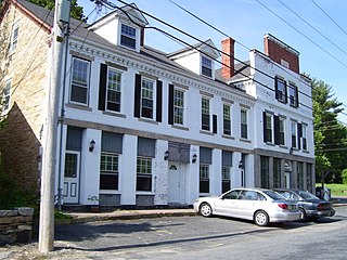
Hope Valley is a village and census-designated place (CDP) in the town of Hopkinton, Rhode Island, United States. The population of the CDP was 1,612 at the 2010 census. Hope Valley is the largest village in Hopkinton, and the town's principal commercial center. While the village of Hope Valley is located in Hopkinton, its ZIP Code, 02832, extends into the neighboring town of Richmond.
Hopkinton is a town in Washington County, Rhode Island. The population was 8,398 at the 2020 census.

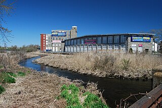
Manville is a village in the town of Lincoln in Providence County, Rhode Island, United States. It is located at latitude 41.9616° North, longitude 71.4744° West. It has been assigned the ZIP Code 02838.
Chariho is a regional school district located in southern Rhode Island shared by three adjacent towns; Charlestown, Richmond, and Hopkinton. The name Chariho is a portmanteau derived by taking the first two letters from each town name and combining them together. The district operates four elementary schools, two of which are located in Hopkinton, in the villages of Ashaway and Hope Valley, one in Charlestown, and one in Richmond. The Chariho campus located in the Richmond village of Wood River Junction houses the Middle and High Schools, as well as the Chariho Career And Technical Center.

Apponaug is a neighborhood in central Warwick, Rhode Island, United States, situated on Apponaug Cove, a tributary to Greenwich Bay and nearby Narragansett Bay. The name Apponaug is a derivation of the Narragansett Indian word for "place of oysters". Indeed, Apponaug Cove holds one of the richest shellfish beds in the United States and was densely populated by the Narragansett people for many centuries prior to the arrival of European settlers.
The Quequechan River is a river in Fall River, Massachusetts, that flows in a northwesterly direction from the northwest corner of the South Watuppa Pond through the heart of the city of Fall River and into the end of the Taunton River at Mount Hope Bay at Heritage State Park/Battleship Cove. The word Quequechan means "Falling River" or "Leaping/Falling Waters" in Wampanoag, hence the city's name.

Smith Hill is a neighborhood in Providence, Rhode Island. Its traditional bounds are the Woonasquatucket River, the Chad Brown public housing complex, Interstate 95 and West River.

The Wood River is a river in the U.S. states of Connecticut and Rhode Island. It flows approximately 25 miles (40 km) and is a major tributary of the Pawcatuck River. There are eight dams along the river's length.

The Green Fall River is a river in the U.S. states of Connecticut and Rhode Island. It flows approximately 13 km (8 mi).
Abbott Run is a de facto river in the U.S. state of Massachusetts and Rhode Island. It flows approximately 10 miles (16 km).
Forestdale is a village and historic district in North Smithfield, Providence County, Rhode Island, United States, one-half mile from Slatersville, Rhode Island. The historic district runs east and west along Main Street and north on Maple Avenue. School Street is the primary road through the village, and the one-room schoolhouse for which the street is named still stands. The Branch River runs through the valley adjacent to the School Street. The Village Haven Restaurant and local VFW chapter are also located in the village.
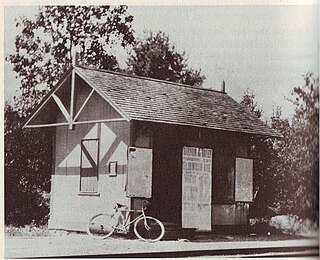
Primrose is a village in North Smithfield, Rhode Island, United States. The village is located in the area around Greenville Road and Providence Pike. The village takes its name from the Primrose railroad station which existed on Greenville Road for the Providence and Springfield Railroad which began service in 1873. The Primrose Fire Department and North Smithfield High School are located in the area. The historic Primrose Grange (1887) building is located on Grange Road as well as several eighteenth-century farms surrounded by stonewalls.

Rockville is a village in the town of Hopkinton, Washington County, Rhode Island, United States. The zip code is 02873.

Arnold Mills Historic District is a historic district encompassing a modest 19th-century mill village in eastern Cumberland, Rhode Island. The district lies along the Nate Whipple Highway and Sneech Pond Road, south of the Arnold Mills Reservoir. Sneech Pond Road was formerly the major east-west highway through the area prior to the construction of the Nate Whipple Highway in the 1960s. The Arnold Mills village is in part bisected by Abbott Run, the stream which serves as the outlet of the reservoir; Sneech Pond Road crosses the run on an early 20th-century steel Pratt pony truss, now closed to vehicular traffic. The houses along this road generally date from the late 18th to mid-19th century, and mainly reflect Federal and Greek Revival styling. The most prominent structure in the district is the Arnold Mills United Methodist Church, located at the western end of the district on Nate Whipple Highway; it was built 1825-27 and remodeled in 1846.

Washington County, known locally as South County, is a county located in the U.S. state of Rhode Island. As of the 2020 census, the population was 129,839. Rhode Island counties have no governmental functions other than as court administrative boundaries, which are part of the state government.

The Pachaug River is a 16.0-mile-long (25.7 km) river arising from the Pachaug State Forest at the Connecticut - Rhode Island border and draining into the Quinebaug River. It is crossed by the Ashland Mill Bridge in Griswold, Connecticut, a bridge which is listed on the U.S. National Register of Historic Places.

The area known as Locustville is today a section of the village of Hope Valley in the town of Hopkinton, Rhode Island, United States.

Arcadia is a village in the towns of Richmond and Exeter in the U.S. state of Rhode Island.
Barberville is a small village located primarily in the town of Hopkinton, but also extending into Richmond in Washington County, Rhode Island, United States. Barberville is located to the north of Hopkinton's principal village, Hope Valley and uses Hope Valley's zip code, 02832.
