Lake Belvedere Estates is a census-designated place (CDP) in Palm Beach County, Florida, United States. It is part of the Miami metropolitan area of South Florida. The population was 2,091 at the 2020 US census.
Schall Circle is a census-designated place (CDP) in Palm Beach County, Florida, United States. It is part of the Miami metropolitan area of South Florida. The population was 792 at the 2020 US census.

Oaklawn-Sunview is a census-designated place (CDP) in Sedgwick County, Kansas, United States. As of the 2020 census, the population was 2,880. It is located on the south side of Wichita along the west side of K-15 and 47th Street South intersection.

Nellieburg is an unincorporated community and census-designated place (CDP) in Lauderdale County, Mississippi, United States. The population was 1,316 at the 2020 census. It is a suburb of Meridian.
Melville is a census-designated place (CDP) in the towns of Middletown and Portsmouth in Newport County, Rhode Island, United States. It lies along the shore of Narragansett Bay. The population of the CDP was 1,320 at the 2010 census. The CDP is named after Admiral George Wallace Melville. Past names for the area include Portsmouth Grove and Bradford.

Newport East is a census-designated place (CDP) in the town of Middletown, Newport County, Rhode Island, United States. The CDP encompasses the portion of the urban area of the city of Newport that extends beyond the municipal boundaries. The population of the CDP was 11,769 at the 2010 census.

Cumberland Hill is a census-designated place (CDP) in the town of Cumberland, in Providence County, Rhode Island, United States. The population was 7,934 at the 2010 census.

Greenville is a village and census-designated place (CDP) in the town of Smithfield in Providence County, Rhode Island, United States. The population was 8,658 at the 2010 census. The CDP is centered on the village of Greenville but also encompasses the nearby villages of West Greenville and Spragueville, as well as the Mountaindale Reservoir and beach.

Harrisville is a census-designated place (CDP) and village in the town of Burrillville in Providence County, Rhode Island, United States. The population was 1,605 at the 2010 census. Much of the community composes a historic district listed on the National Register of Historic Places. The village was named after nineteenth century manufacturer Andrew Harris. Previously, the village was named Rhodesville, after Captain William Rhodes, an eighteenth century privateer.

Valley Falls is a village and census-designated place (CDP) in the town of Cumberland, Providence County, Rhode Island, United States. The population was 12,094 at the 2020 census.

Ashaway is an unincorporated village and census-designated place (CDP) in the town of Hopkinton, Rhode Island, United States. It is a principal village of Hopkinton, along with Hope Valley, although it is the smaller of the two. The population was 1,485 at the 2010 census. The name Ashaway is derived from the American Indian name for the river that runs through the village, the Ashawague or Ashawaug, which means "land in the middle" or "land between" in the Niantic and Mohegan languages. The name "Ashawague River" appears as late as 1832 on the Findley map of Rhode Island published in Philadelphia.

Bradford is a census-designated place (CDP) and historic district in the towns of Westerly and Hopkinton in Washington County, Rhode Island, United States. The population was 1,406 at the 2010 census. The Bradford Village Historic District was listed on the National Register of Historic Places in 1996 as a 224-acre (91 ha) area including 149 contributing buildings, one other contributing site, and one other contributing structure. The CDP as defined by the United States Census Bureau is located only in Westerly.

Hope Valley is a village and census-designated place (CDP) in the town of Hopkinton, Rhode Island, United States. The population of the CDP was 1,612 at the 2010 census. Hope Valley is the largest village in Hopkinton, and the town's principal commercial center. While the village of Hope Valley is located in Hopkinton, its ZIP Code, 02832, extends into the neighboring town of Richmond.

Wakefield-Peacedale is a census-designated place (CDP) in the town of South Kingstown in Washington County, Rhode Island, United States that includes the villages of Peace Dale and Wakefield. The population was 8,487 at the 2010 census.
Pine Ridge is a census-designated place (CDP) and the most populous community in Oglala Lakota County, South Dakota, United States. The population was 3,138 at the 2020 census. It is the tribal headquarters of the Oglala Sioux Tribe on the Pine Ridge Indian Reservation.

Tiverton is a census-designated place (CDP) in Newport County, Rhode Island, United States. The CDP encompasses the town center of Tiverton and the adjacent village of North Tiverton. The population of the CDP was 7,557 at the 2010 census.

Weekapaug is a census-designated place in southern Washington County, Rhode Island, part of the town of Westerly, Rhode Island. The population was 425 at the 2010 census.

Milton is a census-designated place (CDP) in Sumner County, Kansas, United States. As of the 2020 census, the population was 155. It is located 4.5 miles (7.2 km) southeast of Norwich at the intersection of N Argonia Rd and W 120th Ave N, next to the railroad.
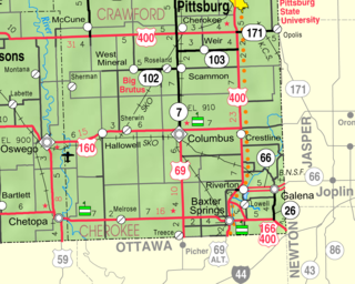
Hallowell is a census-designated place (CDP) in Cherokee County, Kansas, United States. As of the 2020 census, the population was 101.

Kickapoo Tribal Center is a census-designated place (CDP) in Brown County, Kansas, United States, on the Kickapoo Indian Reservation. As of the 2020 census, the population was 177, making it the most populous location within the reservation.


