Related Research Articles

North Smithfield is a town in Providence County, Rhode Island, United States, settled as a farming community in 1666 and incorporated into its present form in 1871. North Smithfield includes the historic villages of Forestdale, Primrose, Waterford, Branch Village, Union Village, Park Square, and Slatersville. The population was 12,588 at the 2020 census.

Charlestown is a town in Washington County, Rhode Island, United States. The population was 7,997 at the 2020 census.
Hopkinton is a town in Washington County, Rhode Island. The population was 8,398 at the 2020 census.

The Pawcatuck River is a river in the US states of Rhode Island and Connecticut flowing approximately 34 miles (55 km). There are eight dams along the river's length. USS Pawcatuck was named after the river.
The Beaver River is a river in the U.S. state of Rhode Island. It flows approximately 11.0 miles (17.7 km). There are three dams along the river's length. The river is also famous locally for its trout fishing in the spring.

Hillsgrove, originally Hill's Grove, is a village in western central Warwick, Rhode Island.
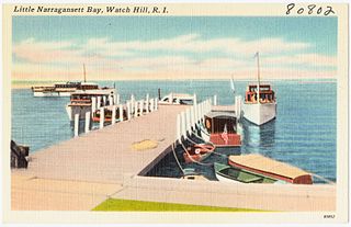
Little Narragansett Bay is an inlet of the Atlantic Ocean and an estuary of the Pawcatuck River on the Rhode Island–Connecticut state line. It is sheltered by the curving peninsula of Napatree Point.

Alton is a small village of approximately 250 residents within the town of Richmond, Rhode Island, United States. It is located about one hour south of Providence, the state's capital. The village is primarily residential, with no retail stores. Alton is located at a crossing of the Wood River and is five miles from the Pawcatuck River.

The Wood River is a river in the U.S. states of Connecticut and Rhode Island. It flows approximately 25 miles (40 km) and is a major tributary of the Pawcatuck River. There are eight dams along the river's length.
The Usquepaug River is a river in the U.S. state of Rhode Island. It flows approximately 12 km (7.5 mi) and is a major tributary of the Pawcatuck River. There are two dams along the river's length.

U.S. Route 1 (US 1) is a major north–south U.S. Route through the U.S. state of Rhode Island, specifically within the Providence metropolitan area. Staying close to the Atlantic Ocean and Narragansett Bay, it is a longer route than Interstate 95 (I-95), and many portions are a four-lane divided highway.
Carolina is a village that straddles the border of the towns of Charlestown and Richmond on the Pawcatuck River in Washington County, Rhode Island, United States. Rhode Island Route 112 passes through the village. Carolina is identified as a census-designated place, with a population of 970 at the 2010 census.

Kenyon is a small village in the town of Richmond near its border with the town of Charlestown in the U.S. state of Rhode Island.
Oakland is a village in Burrillville, Providence County, Rhode Island, United States. It was developed in the 19th century at the site of a stone mill near the confluence of the Chepachet and Clear Rivers. It is one of the few remaining stone mills in this state. Most of the village is included in the Oakland Historic District, a historic district listed on the National Register of Historic Places. Most of the housing in the village was originally built to house mill workers, although there are several more elaborate houses built for mill executives.
Albion is a village and historic district in Lincoln, Rhode Island, in the United States.
Lonsdale is a village and historic district in Lincoln and Cumberland, Providence County, Rhode Island, United States, near Rhode Island Route 146 and Route 95. The village was originally part of the town of Smithfield until Lincoln was created in the 1870s, and was originally centered on the Lincoln side of the Blackstone River. William Blaxton settled in the area in 1635. In the nineteenth and early twentieth centuries, Lonsdale was home to several manufacturers including the Lonsdale Company's Bleachery, and the Ann & Hope mill was also located in the village in Cumberland.

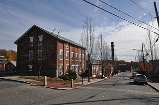
The Shannock Historic District is a historic mill village located along the Pawcatuck River in the towns of Richmond and Charlestown, Rhode Island. The postal code for Shannock is 02875. The village extends along Old Shannock Road, Railroad Street, and Shannock Village Road between two crossings of the Pawcatuck, which forms the border between the two towns. It lies mainly in Richmond, but extends along the road running southwest and southeast from the two crossings. Two mill complexes are the visual focal points of the village: the Carmichael plant on the west, and the Columbia Narrow Fabrics Company complex near the village center. The buildings in the village are predominantly residential worker housing set close to the road, which were built in the second half of the 19th century. There are two imposing Greek Revival houses, both built c. 1850, and one Late Victorian house, all of which belonged to mill owners. The area was listed on the National Register of Historic Places in 1983.

Washington County, known locally as South County, is a county located in the U.S. state of Rhode Island. As of the 2020 census, the population was 129,839. Rhode Island counties have no governmental functions other than as court administrative boundaries, which are part of the state government.
Canonchet is a small village in the town of Hopkinton in the U.S. state of Rhode Island.
Barberville is a small village located primarily in the town of Hopkinton, but also extending into Richmond in Washington County, Rhode Island, United States. Barberville is located to the north of Hopkinton's principal village, Hope Valley and uses Hope Valley's zip code, 02832.
References
- ↑ "Burdickville: Rhode Island Blueways". exploreri.org. Retrieved May 7, 2023.
- ↑ "Pawcatuck River at Burdickville, RI". waterdata.usgs.gov. Retrieved May 7, 2023.
- ↑ Cole, Jim (May 5, 2009). Paddling Connecticut and Rhode Island: Southern New England's Best Paddling Routes. Rowman & Littlefield. ISBN 978-0-7627-5773-2.
- ↑ Historial and Architectural Resources of Charlestown, Rhode Island: A Preliminary Report (1981), p. 22-23
- ↑ Report of Pawcatcuk River (May 14, 1929)
- ↑ (August 23, 1931). Rhody's One-Man Village: William Clark is "Mayor, Owner, Sole Winter Inhabitant of Burdickville - Population Doubles in Summer, The Providence Journal
U.S. Geological Survey Geographic Names Information System: Burdickville, Rhode Island
Municipalities and communities of Washington County, Rhode Island, United States | ||
|---|---|---|
| Towns |  | |
| CDPs | ||
| Other villages | ||
| Indian reservation | ||
41°25′05″N71°43′58″W / 41.41806°N 71.73278°W
| | This Rhode Island state location article is a stub. You can help Wikipedia by expanding it. |