Narragansett, Rhode Island

Last updated

Narragansett, Rhode Island
Narragansett, Rhode Island (53845090729).jpg
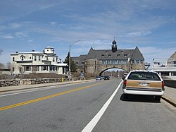
The Towers in Narragansett
Narragansett Seal.png
Narragansett RI lg.PNG
Location of Narragansett in Washington County, Rhode Island
Coordinates: 41°26′4″N71°27′45″W / 41.43444°N 71.46250°W / 41.43444; -71.46250
Country United States
State Rhode Island
County Washington
Area
  Total
37.8 sq mi (97.8 km2)
  Land14.1 sq mi (36.6 km2)
  Water23.6 sq mi (61.2 km2)
Elevation
20 ft (6 m)
Population
 (2020)
  Total
14,532
  Density1,028/sq mi (397.0/km2)
Time zone UTC-5 (Eastern (EST))
  Summer (DST) UTC-4 (EDT)
ZIP Codes
02874 (Saunderstown), 02882 (Narragansett)
Area code 401
FIPS code 44-48340 [1]
Website www.narragansettri.gov

Narragansett is a town in Washington County, Rhode Island, United States. The population was 14,532 at the 2020 census. [2] However, during the summer months the town's population more than doubles to near 34,000. [3] The town of Narragansett occupies a narrow strip of land running along the eastern bank of the Pettaquamscutt River (aka Narrow River) to the shore of Narragansett Bay on the Atlantic Ocean. It was separated from South Kingstown in 1888 and incorporated as a town in 1901. With several ocean beaches and a walkable strip along the ocean front, Narragansett is a resort area in the summer season as well as a popular East Coast surfing spot due to frequent southerly swells from Atlantic Ocean.

Contents

For geographic and demographic information on the village of Narragansett Pier, which is part of Narragansett, see the article on Narragansett Pier.

Geography

According to the United States Census Bureau, the town has a total area of 37.8 square miles (98 km2), of which 14.1 square miles (37 km2) is land and 23.6 square miles (61 km2) (62.56%) is water.

The following villages and neighborhoods are wholly or partially located in Narragansett: Saunderstown (shared with North Kingstown), South Ferry, Bonnet Shores, Narragansett Pier, Point Judith, Galilee, Great Island, Salt Pond, Mettatuxet, and Jerusalem (shared with South Kingstown).

Climate

Narragansett is located in the Köppen climate classification Cfa (mild temperate climate). The period from May through mid November is often warm to mild (occasionally hot in June, July, and August) with frequent sunny skies and modest rainfall. The cold season from December through March features cool to cold weather with high temperatures from 40 F (4.4 C) to 49 F (9.4 C). Normally snowfall is light and melts quickly due to the oceanic location. The area averages about 200 frost - free days annually. Narragansett averages 2300 hrs of sunshine annually (slightly higher than the USA average). Narragansett is located in USDA garden zone 7a/7b.

Climate data for Narragansett, Rhode Island
MonthJanFebMarAprMayJunJulAugSepOctNovDecYear
Record high °F (°C)66
(19)
65
(18)
79
(26)
89
(32)
91
(33)
94
(34)
98
(37)
96
(36)
93
(34)
83
(28)
74
(23)
70
(21)
98
(37)
Mean daily maximum °F (°C)40
(4)
42
(6)
49
(9)
59
(15)
69
(21)
78
(26)
83
(28)
82
(28)
75
(24)
65
(18)
54
(12)
45
(7)
62
(17)
Mean daily minimum °F (°C)22
(−6)
23
(−5)
29
(−2)
38
(3)
48
(9)
58
(14)
64
(18)
63
(17)
56
(13)
45
(7)
36
(2)
27
(−3)
42
(6)
Record low °F (°C)−6
(−21)
−6
(−21)
3
(−16)
19
(−7)
31
(−1)
41
(5)
50
(10)
49
(9)
35
(2)
27
(−3)
15
(−9)
4
(−16)
−6
(−21)
Average precipitation inches (mm)3.66
(93)
3.23
(82)
4.52
(115)
3.90
(99)
3.54
(90)
3.90
(99)
3.66
(93)
4.03
(102)
3.90
(99)
4.64
(118)
3.78
(96)
4.52
(115)
47.28
(1,201)
Average snowfall inches (cm)7
(18)
7
(18)
3
(7.6)
0
(0)
0
(0)
0
(0)
0
(0)
0
(0)
0
(0)
0.1
(0.25)
1
(2.5)
3
(7.6)
21.1
(53.95)
Source: [4]

Demographics

Historical population
CensusPop.Note
1890 1,408
1900 1,5238.2%
1910 1,250−17.9%
1920 993−20.6%
1930 1,25826.7%
1940 1,56024.0%
1950 2,28846.7%
1960 3,44450.5%
1970 7,138107.3%
1980 12,08869.3%
1990 14,98524.0%
2000 16,3619.2%
2010 15,868−3.0%
2020 14,532−8.4%
U.S. Decennial Census [5] [6]

2020 census

The 2020 United States census counted 3,308 people, 1,596 households, and 954 families in Narragansett Pier. The population density was 927.4 per square mile (358.1/km2). There were 2,310 housing units at an average density of 647.6 per square mile (250.0/km2). [7] [8] The racial makeup was 92.08% (3,046) white or European American (91.54% non-Hispanic white), 1.03% (34) black or African-American, 0.48% (16) Native American or Alaska Native, 1.84% (61) Asian, 0.06% (2) Pacific Islander or Native Hawaiian, 0.94% (31) from other races, and 3.57% (118) from two or more races. [9] Hispanic or Latino of any race was 2.0% (66) of the population. [10]

Of the 1,596 households, 10.0% had children under the age of 18; 38.0% were married couples living together; 36.7% had a female householder with no spouse or partner present. 41.9% of households consisted of individuals and 20.9% had someone living alone who was 65 years of age or older. [7] The average household size was 2.0 and the average family size was 2.5. [11] The percent of those with a bachelor’s degree or higher was estimated to be 42.3% of the population. [12]

9.9% of the population was under the age of 18, 10.9% from 18 to 24, 15.4% from 25 to 44, 30.6% from 45 to 64, and 33.2% who were 65 years of age or older. The median age was 56.6 years. For every 100 females, the population had 110.6 males. [7] For every 100 females ages 18 and older, there were 113.2 males. [7]

The 2016-2020 5-year American Community Survey estimates show that the median household income was $79,056 (with a margin of error of +/- $16,106) and the median family income was $125,357 (+/- $25,707). Males had a median income of $52,738 (+/- $15,287) versus $20,882 (+/- $20,090) for females. [13] The median income for those above 16 years old was $31,056 (+/- $18,353). [14] Approximately, 8.2% of families and 17.9% of the population were below the poverty line, including 0.0% of those under the age of 18 and 8.0% of those ages 65 or over. [15] [16]

2000 census

As of the census [1] of 2000, there were 16,361 people, 6,846 households, and 3,847 families residing in the town. The population density was 1,156.5 inhabitants per square mile (446.5/km2). There were 9,159 housing units at an average density of 647.4 per square mile (250.0/km2). The racial makeup of the town was 95.84% White, 0.75% African American, 0.90% Native American, 0.76% Asian, 0.02% Pacific Islander, 0.34% from other races, and 1.40% from two or more races. Hispanic or Latino of any race were 1.25% of the population.

There were 6,846 households, out of which 22.0% had children under the age of 18 living with them, 44.6% were married couples living together, 8.7% had a female householder with no husband present, and 43.8% were non-families. Of all households 27.2% were made up of individuals, and 9.0% had someone living alone who was 65 years of age or older. The average household size was 2.38 and the average family size was 2.86.

In the town, the population was spread out, with 17.3% under the age of 18, 19.6% from 18 to 24, 25.0% from 25 to 44, 24.6% from 45 to 64, and 13.5% who were 65 years of age or older. The median age was 36 years. For every 100 females, there were 94.5 males. For every 100 females age 18 and over, there were 92.4 males.

The median income for a household in the town was $50,363, and the median income for a family was $67,571. Males had a median income of $45,436 versus $31,759 for females. The per capita income for the town was $28,194. About 4.9% of families and 16.0% of the population were below the poverty line, including 8.4% of those under age 18 and 5.0% of those age 65 or over. In 2010, Narragansett was estimated to have 2,743 people in poverty; college students represented 71% of that group, and in comparison, statewide college students make up only 13.7 percent of the total population in poverty. This large college factor, in a relatively small community, has a profound impact on the overall poverty rate. [3]

From September through May the town is home to many students from the University of Rhode Island located in nearby Kingston.

Recreation

Scarborough State Beach Narragansettbeach.jpg
Scarborough State Beach
Waves crashing on a rock in the Atlantic Ocean, visible from the Seawall of Narragansett. Narragansett Bay surf on the rocks.jpg
Waves crashing on a rock in the Atlantic Ocean, visible from the Seawall of Narragansett.

Narragansett is known for its summer recreation and beaches. [17] Fishermen's Memorial State Park, located near Galilee, contains a former military fort (Fort Greene) and a campground.

Three beaches in Narragansett that are most famous are:

Education

Narragansett operates its own Pre-K through 12 educational system with three schools: Narragansett Elementary School, Narragansett Pier Middle School, and Narragansett High School. The Narragansett High School principal, Mr. Daniel F. Warner, was voted the 2008 Principal of the Year. The South County Museum is located within the town. The Narragansett Bay Campus of the University of Rhode Island is located in Narragansett.

Housing

Narragansett has prohibited more than three college students from living together per housing unit. [22]

Water supply

The town is served by two drinking water organizations divided into four systems:

Economy

Top employers

According to Narragansett's 2012 Comprehensive Annual Financial Report, [26] the top employers in the city are:

#Employer# of Employees
1Town of Narragansett448
2 University of Rhode Island Narragansett Bay Campus245
3 Stop & Shop 225
4 The Dunes Club 180
5 VNS Home Health Service 150
6 Environmental Protection Agency 160
7DeWal Industries120
8George's of Galilee100
9 National Marine Fisheries Service 70

Places of worship

National Register of Historic Places

The Towers, which pass over Ocean Road along Rhode Island Sound, is Narragansett's most famous landmark. Narragansettbuilding.jpg
The Towers, which pass over Ocean Road along Rhode Island Sound, is Narragansett's most famous landmark.

Thirteen different buildings and districts in Narragansett are listed on the National Register of Historic Places: [27]

Notable people

See also

Related Research Articles

<span class="mw-page-title-main">Warwick, Rhode Island</span> City in Rhode Island, United States

Warwick is a city in Kent County, Rhode Island, United States, and is the third-largest city in the state, with a population of 82,823 at the 2020 census. Warwick is located approximately 12 miles (19 km) south of downtown Providence, Rhode Island, 63 miles (101 km) southwest of Boston, Massachusetts, and 171 miles (275 km) northeast of New York City.

<span class="mw-page-title-main">Melville, Rhode Island</span> CDP in Rhode Island, United States

Melville is a census-designated place (CDP) in the towns of Middletown and Portsmouth in Newport County, Rhode Island, United States. It lies along the shore of Narragansett Bay. The population of the CDP was 1,320 at the 2010 census. The CDP is named after Admiral George Wallace Melville. Past names for the area include Portsmouth Grove and Bradford.

<span class="mw-page-title-main">Central Falls, Rhode Island</span> City in Rhode Island, United States

Central Falls is a city in Providence County, Rhode Island, United States. The population was 22,583 at the 2020 census. With an area of only 1.29 square miles (3.3 km2), it is the smallest and most densely populated city in the smallest state, and the 23rd most densely populated incorporated place in the United States. It is also one of only four incorporated places in New England that have a higher population density than the city of Boston. The city takes its name from a waterfall on the Blackstone River.

<span class="mw-page-title-main">Cranston, Rhode Island</span> City in Rhode Island, United States

Cranston, formerly known as Pawtuxet, is a city in Providence County, Rhode Island, United States. The official population of the city in the 2020 United States Census was 82,934, making it the second-largest city in the state. The center of population of Rhode Island is located in Cranston. Cranston is a part of the Providence metropolitan area.

<span class="mw-page-title-main">East Providence, Rhode Island</span> City in Rhode Island, United States

East Providence is a city in Providence County, Rhode Island, United States. The population was 47,139 at the 2020 census, making it the fifth-largest city in the state.

<span class="mw-page-title-main">Greenville, Rhode Island</span> Census-designated place in Rhode Island, United States

Greenville is a village and census-designated place (CDP) in the town of Smithfield in Providence County, Rhode Island, United States. The population was 8,658 at the 2010 census. The CDP is centered on the village of Greenville but also encompasses the nearby villages of West Greenville and Spragueville, as well as the Mountaindale Reservoir and beach.

<span class="mw-page-title-main">Pawtucket, Rhode Island</span> City in Rhode Island, United States

Pawtucket is a city in Providence County, Rhode Island. The population was 75,604 at the 2020 census, making the city the fourth-largest in the state. Pawtucket borders Providence and East Providence to the south, Central Falls and Lincoln to the north, and North Providence to the west. The city also borders the Massachusetts municipalities of Seekonk and Attleboro.

<span class="mw-page-title-main">Woonsocket, Rhode Island</span> City in Rhode Island, United States

Woonsocket, is a city in Providence County, Rhode Island, United States. The population was 43,240 at the 2020 census, making it the sixth largest city in the state. Being Rhode Island's northernmost city, Woonsocket lies directly south of the Massachusetts state line and constitutes part of both the Providence metropolitan area and the larger Greater Boston Combined Statistical Area.

<span class="mw-page-title-main">Charlestown, Rhode Island</span> Town in Rhode Island, United States

Charlestown is a town in Washington County, Rhode Island, United States. The population was 7,997 at the 2020 census.

<span class="mw-page-title-main">Exeter, Rhode Island</span> Town in Rhode Island, United States

Exeter is a town in Washington County, Rhode Island, United States. Exeter extends east from the Connecticut border to the town of North Kingstown. It is bordered to the north by West Greenwich and East Greenwich, and to the south by Hopkinton, Richmond, and South Kingstown. Exeter's postal code is 02822, although small parts of the town have the mailing address West Kingston (02892) or Saunderstown (02874). The population was 6,460 at the 2020 census.

<span class="mw-page-title-main">Narragansett Pier, Rhode Island</span> CDP in Rhode Island, United States

Narragansett Pier is an unincorporated village and a census-designated place (CDP) in the town of Narragansett in Washington County, Rhode Island, United States. The population was 3,409 at the 2010 census.

<span class="mw-page-title-main">North Kingstown, Rhode Island</span> Town in Rhode Island, United States

North Kingstown is a town in Washington County, Rhode Island, United States, and is part of the Providence metropolitan area. The population was 27,732 in the 2020 census. North Kingstown is home to the birthplace of American portraitist Gilbert Stuart, who was born in the village of Saunderstown. Within the town is Quonset Point, location of the former Naval Air Station Quonset Point, known for the invention of the Quonset hut, as well as the historic village of Wickford.

<span class="mw-page-title-main">Richmond, Rhode Island</span> Town in Rhode Island, United States

Richmond is a town in Washington County, Rhode Island, United States. The population was 8,020 at the 2020 census. It contains the villages of Alton, Arcadia, Barberville, Carolina, Hillsdale, Kenyon, Shannock, Tug Hollow, Usquepaug, Wood River Junction, Woodville, and Wyoming. Students in Richmond are part of the Chariho Regional School District.

<span class="mw-page-title-main">South Kingstown, Rhode Island</span> Town in Rhode Island, United States

South Kingstown is a town in, and the county seat of, Washington County, Rhode Island, United States. The population was 31,931 at the 2020 census. South Kingstown is the second largest town in Rhode Island by total geographic area, behind New Shoreham, and the third largest town in Rhode Island by geographic land area, behind Exeter and Coventry.

<span class="mw-page-title-main">Wakefield-Peacedale, Rhode Island</span> CDP in Rhode Island, United States

Wakefield-Peacedale is a census-designated place (CDP) in the town of South Kingstown in Washington County, Rhode Island, United States that includes the villages of Peace Dale and Wakefield. The population was 8,487 at the 2010 census.

<span class="mw-page-title-main">Kingston, Rhode Island</span> Census-designated place in Rhode Island, United States

Kingston is a village and a census-designated place within the town of South Kingstown in Washington County, Rhode Island, United States, and the site of the main campus of the University of Rhode Island. The population was 6,974 at the 2010 census. Much of the village center is listed on the National Register of Historic Places as Kingston Village Historic District. It was originally known as Little Rest.

<span class="mw-page-title-main">Quonochontaug, Rhode Island</span> Village in Rhode Island, United States

Quonochontaug is a village in Washington County, Rhode Island, United States. It is composed of three small beach communities, and is part of Charlestown.

<span class="mw-page-title-main">Carolina, Rhode Island</span> United States historic place

Carolina is a village that straddles the border of the towns of Charlestown and Richmond on the Pawcatuck River in Washington County, Rhode Island, United States. Rhode Island Route 112 passes through the village. Carolina is identified as a census-designated place, with a population of 970 at the 2010 census.

<span class="mw-page-title-main">Washington County, Rhode Island</span> County in Rhode Island, United States

Washington County, known locally as South County, is a county located in the U.S. state of Rhode Island. As of the 2020 census, the population was 129,839. Rhode Island counties have no governmental functions other than as court administrative boundaries, which are part of the state government.

<span class="mw-page-title-main">Misquamicut, Rhode Island</span> Census-designated place and Village in Rhode Island, United States

Misquamicut is a census-designated place and fire district in southern Washington County, Rhode Island, United States. It is part of the town of Westerly. The population was listed as 390 in the 2010 census.

References

  1. 1 2 "U.S. Census website". United States Census Bureau . Retrieved January 31, 2008.
  2. "Growth in cities drove RI population increase in 2020 Census".
  3. MSN weather records and averages for Narragansett, RI
  4. "Census of Population and Housing". Census.gov. Retrieved June 4, 2016.
  5. Snow, Edwin M. (1867). Report upon the Census of Rhode Island 1865. Providence, RI: Providence Press Company.
  6. 1 2 3 4 "US Census Bureau, Table DP1: PROFILE OF GENERAL POPULATION AND HOUSING CHARACTERISTICS". data.census.gov. Retrieved December 29, 2023.
  7. "Gazetteer Files". Census.gov. Retrieved December 30, 2023.
  8. "US Census Bureau, Table P1: RACE". data.census.gov. Retrieved December 29, 2023.
  9. "US Census Bureau, Table P2: HISPANIC OR LATINO, AND NOT HISPANIC OR LATINO BY RACE". data.census.gov. Retrieved December 29, 2023.
  10. "US Census Bureau, Table S1101: HOUSEHOLDS AND FAMILIES". data.census.gov. Retrieved December 29, 2023.
  11. "US Census Bureau, Table S1501: EDUCATIONAL ATTAINMENT". data.census.gov. Retrieved December 29, 2023.
  12. "US Census Bureau, Table S1903: MEDIAN INCOME IN THE PAST 12 MONTHS (IN 2020 INFLATION-ADJUSTED DOLLARS)". data.census.gov. Retrieved December 29, 2023.
  13. "US Census Bureau, Table S2001: EARNINGS IN THE PAST 12 MONTHS (IN 2020 INFLATION-ADJUSTED DOLLARS)". data.census.gov. Retrieved December 29, 2023.
  14. "US Census Bureau, Table S1701: POVERTY STATUS IN THE PAST 12 MONTHS". data.census.gov. Retrieved December 29, 2023.
  15. "US Census Bureau, Table S1702: POVERTY STATUS IN THE PAST 12 MONTHS OF FAMILIES". data.census.gov. Retrieved December 29, 2023.
  16. "Narragansett Ri tourism,vacation rental,restaurants". Narragansett Ri tourism,vacation rental,restaurants. Retrieved March 23, 2018.
  17. "Narragansett Town Beach". narragansettri.com. Retrieved March 23, 2018.
  18. Roger Wheeler State Beach Archived March 25, 2010, at the Wayback Machine
  19. Salty Brine State Beach Archived March 25, 2010, at the Wayback Machine
  20. NEWS, CRYSTAL BUI, NBC 10 (March 14, 2017). "Wind turbine at Narragansett beach collapses in storm". turnto10.com. Retrieved March 23, 2018.{{cite web}}: CS1 maint: multiple names: authors list (link) CS1 maint: numeric names: authors list (link)
  21. Naylor, Donita. "Narragansett gives initial OK to housing limit: 3 students per unit". The Providence Journal. Retrieved February 16, 2022.
  22. "NARRAGANSETT WATER DEPT-NORTH END Consumer RI1858429 (Source of Supply- SUEZ Water) Confidence Report – 2021". Town of Narragansett. 2021. Retrieved January 8, 2022.
  23. "NARRAGANSETT WATER DEPT-NORTH END RI1858429 (Source of Supply- North Kingstown) Consumer Confidence Report – 2021". Town of Narragansett. 2021. Retrieved January 8, 2022.
  24. "NARRAGANSETT WATER SYSTEM-POINT JUDITH Consumer Confidence Report – 2021". Town of Narragansett. 2021. Retrieved January 8, 2022.
  25. "Town of Narragansett CAFR". narragansettri.gov. Retrieved March 23, 2018.
  26. "National Register Information System". National Register of Historic Places . National Park Service. January 23, 2007.
  27. D’Auria, Peter (May 9, 2021). "Narragansett council handed Fulop a defeat in parking battle. Then the mayor lashed out at the media". The Jersey Journal.
  28. Duguay, Rob (December 8, 2015). "Interview: Now Christmas collaborators, Aimee Mann and Ted Leo find common musical ground". Vanyaland. Retrieved September 1, 2016.