Beavertail State Park is a public recreation area encompassing 153 acres (62 ha) at the southern end of Conanicut Island in Narragansett Bay, Rhode Island. The state park's main attraction is the active Beavertail Lighthouse, the current tower of which dates from 1856. During World War II, the park area was part of Fort Burnside, one of several coastal fortifications designed to protect Narragansett Bay. The park's scenic shoreline offers hiking, picnicking, and saltwater fishing.

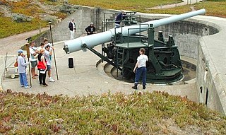
The 16 inch gun M1919 (406 mm) was a large coastal artillery piece installed to defend the United States' major seaports between 1920 and 1946. It was operated by the United States Army Coast Artillery Corps. Only a small number were produced and only seven were mounted; in 1922 and 1940 the US Navy surplussed a number of their own 16-inch/50 guns, which were mated to modified M1919 carriages and filled the need for additional weapons.

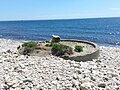
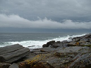
Fort Wetherill is a former coast artillery fort that occupies the southern portion of the eastern tip of Conanicut Island in Jamestown, Rhode Island. It sits atop high granite cliffs, overlooking the entrance to Narragansett Bay. Fort Dumpling from the American Revolutionary War occupied the site until it was built over by Fort Wetherill. Wetherill was deactivated and turned over to the State of Rhode Island after World War II and is now operated as Fort Wetherill State Park, a 51-acre (210,000 m2) reservation managed by the Rhode Island Department of Environmental Management.

Fort Taber District or the Fort at Clark's Point is a historic American Civil War-era military fort on Wharf Road within the former Fort Rodman Military Reservation in New Bedford, Massachusetts. The fort is now part of Fort Taber Park, a 47-acre town park located at Clark's Point. Fort Taber was an earthwork built nearby with city resources and garrisoned 1861-1863 until Fort Rodman was ready for service.
Two Lights State Park is a public recreation area occupying 41 acres (17 ha) of headland on Cape Elizabeth, Maine, that offers views of Casco Bay and the Atlantic Ocean. The state park, which opened in 1961, is named after the twin Cape Elizabeth Lights, although there are no lighthouses in the park itself. In addition to rocky headlands, the park includes the remains of a World War II–era seacoast battery bunker and a fire control tower. It is managed by the Maine Department of Agriculture, Conservation and Forestry.

Odiorne Point State Park is a public recreation area located on the Atlantic seacoast in the town of Rye near Portsmouth, New Hampshire. Among the park's features are the Seacoast Science Center and the remains of the World War II Fort Dearborn. The park offers opportunities for hiking, cycling, picnicking, fishing, and boating.

Fort Getty is a town park in Jamestown, Rhode Island, on Conanicut Island in Narragansett Bay. From 1900 through World War II it was a military fort. The Town of Jamestown later received the property and opened it as a park, primarily a campground.
East Point Military Reservation was a World War I and World War II coastal defense site located in Nahant, Massachusetts. In 1955–62 it was a Nike missile launch site. In 1967 the site was converted into the Marine Science Center of Northeastern University.

Fourth Cliff Military Reservation was a World War II coastal defense site located near Scituate, Massachusetts, USA. It is now a recreation area for Hanscom Air Force Base.
Mishaum Point Military Reservation was a coastal defense site located in Dartmouth, Massachusetts as part of the Harbor Defenses of New Bedford.
Jewell Island is a small island in Casco Bay, Maine, United States. Approximately 1 mile (1.6 km) long from southwest to northeast, it is located off the coast of Cliff Island, approximately eight miles from downtown Portland. It is a state-owned island with a small but protected harbor as well as camping and walking paths. Jewell Island was part of the Harbor Defenses of Portland fort network. The island is part of the city of Portland. Jewell Island can be reached by private or charter boats. There is no ferry service to the island.

Fort Ruckman was a U.S. Coast Artillery fort located in Nahant, Massachusetts. Originally called the Nahant Military Reservation, the fort was laid out in 1904-1907 and covered an area of about 45 acres just northwest of Bass Point, on the southwest side of the Nahant peninsula. During the 1920s, this area was renamed in honor of Maj. Gen. John Wilson Ruckman, a former Colonel in the Coast Artillery.
Fishermen's Memorial State Park is a public recreation area and campground encompassing 91 acres (37 ha) on Point Judith in the town of Narragansett, Rhode Island. The state park occupies a portion of the former Fort Nathaniel Greene, named after Rhode Island native and Revolutionary War general Nathaniel Greene.

Fort Williams is a former United States Army fort in Cape Elizabeth, Maine which operated from 1872 to 1964. It was part of the Coast Defenses of Portland, later renamed the Harbor Defenses of Portland, a command which protected Portland's port and naval anchorage 1904–1950. After its closure, it was redeveloped into Fort Williams Park.

Battery Steele is a United States military fortification on Peaks Island, Portland, Maine in Casco Bay. Completed in 1942 as part of World War II, it is located on 14 acres (5.7 ha) on the oceanside area of the island, formerly part of the Peaks Island Military Reservation. It is named for Harry L. Steele, who was a Coast Artillery officer during World War I. It was armed with two 16-inch MkIIMI guns and, with a 12-inch gun battery at Fort Levett on Cushing Island, replaced all previous heavy guns in the Harbor Defenses of Portland. It was built to protect Casco Bay, particularly Portland harbor, from Kennebunk to Popham Beach in Phippsburg. According to Kim MacIsaac and historian Joel Eastman in An Island at War, “Battery Steele is not only the largest gun battery built on Peaks Island, but also an example of the largest battery ever built anywhere in the United States.” In 1995, after decades of non-use, the Peaks Island Land Preserve, a community land preservation group, formed to purchase the area and forever preserve it as a public space. On October 20, 2005, the property was listed on the National Register of Historic Places. Other coast defense structures on the island include fire control towers and the counterweight for a disappearing searchlight tower.

Fort Church was a World War II United States Army coastal defense fort in Little Compton, Rhode Island. Together with Fort Greene near Point Judith, it superseded all previous heavy gun defenses in the Harbor Defenses of Narragansett Bay.

Camp Varnum is a Rhode Island Army National Guard training facility in the Boston Neck area of Narragansett, Rhode Island. During World War II it was Fort Varnum, a coastal defense fort.
Fort Kearny was a coastal defense fort in the Saunderstown area of Narragansett, Rhode Island from 1901 to 1943. It was a prisoner-of-war camp for German prisoners in 1945. It is now the Narragansett Bay Campus of the University of Rhode Island. In many sources it is spelled Fort Kearney.

The Harbor Defenses of Narragansett Bay was a United States Army Coast Artillery Corps harbor defense command. It coordinated the coast defenses of Narragansett Bay and Rhode Island from 1895 to 1950, beginning with the Endicott program. These included both coast artillery forts and underwater minefields. The command originated circa 1895 as an Artillery District, was renamed Coast Defenses of Narragansett Bay in 1913, and again renamed Harbor Defenses of Narragansett Bay in 1925.
The 243rd Coast Artillery Regiment was a Coast Artillery Corps regiment in the Rhode Island National Guard. It garrisoned the Harbor Defenses of Narragansett Bay, Rhode Island 1924–1944.