Nobska Light, originally called Nobsque Light, also known as Nobska Point Light is a lighthouse located near the division between Buzzards Bay, Nantucket Sound, and Vineyard Sound in the settlement of Woods Hole, Massachusetts on the southwestern tip of Cape Cod, Massachusetts. It overlooks Martha's Vineyard and Nonamesset Island. The light station was established in 1826, with the tower protruding above the keeper's house, and was replaced in 1876 by the current 42 foot tall iron tower. The light station was added to the National Register of Historic Places as Nobska Point Light Station in 1987.

The Point Wilson Light is an active aid to navigation located in Fort Worden State Park near Port Townsend, Jefferson County, Washington. It is one of the most important navigational aids in the state, overlooking the entrance to Admiralty Inlet, the waterway connecting the Strait of Juan de Fuca and Puget Sound. The lighthouse was listed on the Washington State Heritage Register and the National Register of Historic Places in 1971.

Ile Aux Galets Light, also known as Skillagalee Island Light, is located on Ile Aux Galets, a gravelly, low-lying island in northeast Lake Michigan, between Beaver Island and the mainland, approximately 7 miles (11 km) northwest of Cross Village in Emmet County, Michigan. Along with nearby Grays Reef, Waugoshance, and White Shoal Lights, it warns shipping away from the reefs and shoals of Waugoshance Point, which pose an imminent hazard to navigation.

The Cape Flattery Light is a historic lighthouse structure located at the entrance to the Strait of Juan de Fuca near Neah Bay, Clallam County, in the U.S. state of Washington, within the Makah Indian Reservation. The deactivated lighthouse sits on Tatoosh Island, which is named after Chief Tatooche of the Makah Tribe. It is the northwesternmost lighthouse on the West Coast of the contiguous United States. Although closed to the public, it can be viewed from Cape Flattery via a short 30-minute walk.

Point No Point Light is an operational aid to navigation on the northeastern tip of the Kitsap Peninsula on the west side of Puget Sound, at Point No Point where Admiralty Inlet joins Puget Sound, near the small community of Hansville, Kitsap County, in the U.S. state of Washington. Point No Point Light is considered the oldest lighthouse on Puget Sound and is listed on the National Register of Historic Places.
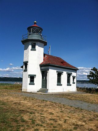
The Point Robinson Light is an operational aid to navigation and historic lighthouse on Puget Sound, located at Point Robinson, the easternmost point of Maury Island, King County, in the U.S. state of Washington. The site was listed on the National Register of Historic Places in 2004.
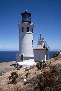
Anacapa Island Lighthouse is a lighthouse in California, United States, on the entrance to Santa Barbara Channel, California. Constructed in 1912, it was the last major light station built on the west coast. Anacapa and several other islands were collectively designated as Channel Islands National Monument in 1938, though the Coast Guard retained responsibility for the Anacapa lighthouse. Now fully automated and unmanned, the light house still operates, but the National Park Service (NPS) is responsible for Channel Islands National Park.

Great Captain Island Lighthouse is a lighthouse on Great Captain Island in the western Long Island Sound off the coast of Greenwich, Connecticut, United States. Built in 1829, the first lighthouse, made of stone, was of such poor construction that the walls were severely cracked a decade later. In 1868, a new granite dwelling with attached lantern was completed. The lighthouse is of the same design as lighthouses at Sheffield Island in Norwalk; Morgan Point in Noank; Old Field Point Light and Plum Island in New York; and Block Island North in Rhode Island. In 1890, a fog whistle was added, in 1905 a siren was installed. The lighthouse was deactivated in 1970 when a skeletal tower replaced it. The Town of Greenwich acquired the property in 1973 and had full-time caretakers on the site until the lighthouse became too dilapidated in 2003. A successful restoration effort was completed in 2009 and a non-navigational light was activated in 2012. In 2010, a memorial plaque was installed to "honor the 23 people who lived in Greenwich, or had a connection to the town", who died in the September 11, 2001 attacks. In 1991, the Great Captain Island Light was added to the National Register of Historic Places.

The Lynde Point Light or Lynde Point Lighthouse, also known as Saybrook Inner Lighthouse, is a lighthouse in Connecticut, United States, on the west side of the mouth of the Connecticut River on the Long Island Sound, Old Saybrook, Connecticut. The first light was a 35 feet (11 m) wooden tower constructed by Abisha Woodward for $2,200 and it was completed in 1803. A new lighthouse was eventually needed and a total of $7,500 was appropriated on July 7, 1838. Jonathan Scranton, Volney Pierce, and John Wilcox were contracted to build the new 65-foot (20 m) octagonal brownstone tower. It was constructed in 1838 and lit in 1839. The lighthouse was renovated in 1867 and had its keeper's house from 1833 replaced in 1858 with a Gothic Revival gambrel-roofed wood-frame house. In 1966, the house was torn down and replaced by a duplex house. The original ten lamps were replaced in 1852 with a fourth-order Fresnel lens, and with a fifth-order Fresnel lens in 1890. Lynde Point Lighthouse used whale oil until 1879 when it switched to kerosene. It was electrified in 1955 and fully automated by the United States Coast Guard in 1978. In 1990, it was added to the National Register of Historic Places and is significant for its "superior stone work in the tapering brownstone walls".

Stratford Point Light is a historic lighthouse in Stratford, Connecticut, United States, at the mouth of the Housatonic River. The second tower was one of the first prefabricated cylindrical lighthouses in the country and remains active.
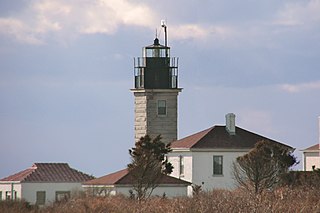
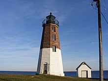
Beavertail Lighthouse was built in 1856 and is the premier lighthouse in Rhode Island, marking the entrance to Narragansett Bay. The 64-foot (20 m) lighthouse lies on the southernmost point of Conanicut Island in the town of Jamestown, Rhode Island in Beavertail State Park, on a site where beacons have stood since the early 18th century. The light provides navigation for boats and ships entering Narragansett Bay in the East Passage between Conanicut Island and Newport, Rhode Island on Aquidneck Island. Other lighthouses are visible from Beavertail Lighthouse, such as Castle Hill Lighthouse, Point Judith Light, and Rose Island Light.

The Fort Point Light, or Fort Point Light Station, is located in Fort Point State Park, in Stockton Springs, Maine. A lighthouse at this point has served as an active aid to navigation since 1835; the present lighthouse dates to 1857, and is listed on the National Register of Historic Places.
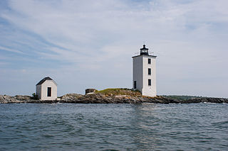
Dutch Island Light is a historic lighthouse on Dutch Island off Jamestown, Rhode Island.

Long Point Light Station is a historic lighthouse at the northeast tip of Long Point in Provincetown, Massachusetts. As a navigational aid, it marks the southwest edge of the entrance to Provincetown Harbor. The United States Coast Guard Light List describes it simply as a "white square tower". The light it casts is green, occulting every 4 seconds, and, at a focal height of 35.5 feet (10.8 m) above mean sea level, has a visible range of 8 nautical miles. When the weather affords low-visibility, one can hear the station's fog horn – sounding a single blast for two seconds, and repeating every 15 seconds – as it seems to call out for its nearly-identical closest neighbor, the Wood End Light.

Plum Island Light is located on the western end of Plum Island, which lies in the Long Island Sound, east of Orient Point at the end of the North Fork of Long Island, New York. An historic granite lighthouse originally built in 1869 sits at the site, but no longer serves as an active aid to navigation. It was listed on the National Register of Historic Places in 2011.

Marshall Point Light Station is a lighthouse at the entrance of Port Clyde Harbor in Port Clyde, Maine. The light station was established in 1832.

Bear Island Light is a lighthouse on Bear Island near Mt. Desert Island, at the entrance to Northeast Harbor, Maine. It was first established in 1839. The present structure was built in 1889. It was deactivated in 1981 and relit as a private aid to navigation by the Friends of Acadia National Park in 1989. Bear Island Light was listed on the National Register of Historic Places as Bear Island Light Station on March 14, 1988.
The Manana Island Sound Signal Station is an active fog signal station on Manana Island, Maine, United States. Established in 1855, it is one of the only separately managed fog signals in the United States, having been operationally independent of Monhegan Island Light for most of its existence. It is also home to the only known fog signal trumpet tower, built in 1889. The station was listed on the National Register of Historic Places as Manana Island Fog Signal Station in 2002.
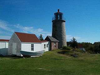
Monhegan Island Light is a lighthouse on Monhegan Island, Maine. It was first established in 1824. The present structure was built in 1850. It was Alexander Parris's last significant design. It is the second highest light in Maine — Seguin Light, with a 6-foot taller tower, is 2 feet higher in elevation. It was listed on the National Register of Historic Places as Monhegan Island Lighthouse and Quarters on May 7, 1980, reference number 80000239.

The Duluth South Breakwater Outer Light is a lighthouse on the south breakwater of the Duluth Ship Canal in Duluth, Minnesota, United States. It forms a range with the Duluth South Breakwater Inner Light to guide ships into the canal from Lake Superior.