Seekonk is a town in Bristol County, Massachusetts, United States, on the Massachusetts border with Rhode Island. It was incorporated in 1812 from the western half of Rehoboth. The population was 15,531 at the 2020 census. In 1862, under a U.S. Supreme Court decision resolving a longstanding border dispute between Massachusetts and Rhode Island, a portion of Tiverton, Rhode Island was awarded to Massachusetts to become part of Fall River, while two-thirds of Seekonk was awarded to Rhode Island.

Pawtucket is a city in Providence County, Rhode Island, United States. The population was 75,604 at the 2020 census, making the city the fourth-largest in the state. Pawtucket borders Providence and East Providence to the south, Central Falls and Lincoln to the north, and North Providence to the west. The city also borders the Massachusetts municipalities of Seekonk and Attleboro.

Narragansett Bay is a bay and estuary on the north side of Rhode Island Sound covering 147 square miles (380 km2), 120.5 square miles (312 km2) of which is in Rhode Island. The bay forms New England's largest estuary, which functions as an expansive natural harbor and includes a small archipelago. Small parts of the bay extend into Massachusetts.
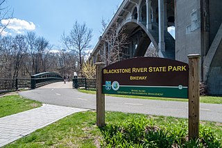
The Blackstone River in the United States is a river that flows through Massachusetts and Rhode Island. It is 48 mi (77 km) long with a drainage area of 475 mi2. It drains into the Pawtucket River at Pawtucket, Rhode Island. Its long history of industrial use in the watershed has caused significant pollution, with the United States Environmental Protection Agency describing it as “the most polluted river in the country because of high concentrations of toxic sediments.”

The Henderson Bridge is a bridge in Rhode Island which spans the Seekonk River, and connects the East Side neighborhood of Providence with the Watchemoket and Phillipsdale neighborhoods of East Providence. After a major reconstruction, the bridge reopened to automobile traffic in phases from November 16 to 20, 2023. A new cycle path opened on November 27. A few weeks later, it was used as a detour during the emergency closure of the westbound half of the parallel Washington Bridge.

The Moshassuck River is a river in the U.S. state of Rhode Island. It flows 8.9 miles (14.3 km) from the town of Lincoln to the city of Providence. There are six dams along the river's length.

The Blackstone Valley or Blackstone River Valley is a region of Massachusetts and Rhode Island. It was a major factor in the American Industrial Revolution. It makes up part of the Blackstone River Valley National Heritage Corridor and National Historical Park.

The East Side Railroad Tunnel is a former railroad tunnel that runs underneath the East Side of Providence, Rhode Island. The tunnel runs 5,080 feet (1,550 m), under College Hill, from Gano Street to just west of Benefit Street. It was opened on November 16, 1908, at a cost of $2 million. All rail service ceased through the tunnel in 1976 and has been abandoned since.

The Pawtuxet River, also known as the Pawtuxet River Main Stem and the Lower Pawtuxet, is a river in the U.S. state of Rhode Island. It flows 12.3 miles (19.8 km) and empties into the upper Narragansett Bay of the Atlantic Ocean. Together with its two main tributary branches, the North Branch Pawtuxet River and the South Branch Pawtuxet River, it drains a watershed of 231.6 square miles (600 km2), all of which is in the state of R.I.

The East Junction Branch is a rail line in Rhode Island and Massachusetts, in the United States. Originally built by the Boston and Providence Railroad (B&P) in 1835, the line connects Attleboro, Massachusetts, and East Providence, Rhode Island via Seekonk, Massachusetts. As built, the line continued across the Seekonk River to Providence via the India Point Railroad Bridge; this connection was removed during the 1970s. The East Junction Branch meets the Northeast Corridor in Attleboro at a point known as East Junction, and ends at a connection to the East Providence Branch in East Providence. CSX Transportation operates freight service on the branch in Attleboro, while the Providence and Worcester Railroad (P&W) operates freight service in East Providence and across the state line into Seekonk. The line is owned by the P&W in Rhode Island, and by the Massachusetts Bay Transportation Authority in Massachusetts.

The Ten Mile River is a river within the U.S. states of Massachusetts and Rhode Island. It flows approximately 22 miles (35 km) and drains a watershed of 54 square miles (140 km2).

Fox Point is a neighborhood in the East Side of Providence, Rhode Island. It is bounded by the Providence and Seekonk rivers, Interstate 195 and the College Hill and Wayland neighborhoods. Fox Point is the southernmost neighborhood in the East Side area of Providence.

The Providence River is a tidal river in the U.S. state of Rhode Island. It flows approximately 8 miles (13 km). There are no dams along the river's length, although the Fox Point Hurricane Barrier is located south of downtown to protect the city of Providence from damaging tidal floods.
The East Side is a collection of neighborhoods in the eastern part of the city of Providence, Rhode Island. It officially comprises the neighborhoods of Blackstone, Hope, Mount Hope, College Hill, Wayland, and Fox Point.

The East Bay Bike Path is a 14.5-mile (23.3 km) paved rail trail in Rhode Island. The path originates in Providence and India Point Park, crosses the Seekonk River via the George Redman Linear Park and the Washington Bridge, and continues southeast to Bristol along the shoreline of Narragansett Bay. The path passes through the city of East Providence, the hamlet of Riverside, and the towns of Barrington and Warren. It is part of the East Coast Greenway, a 3,000-mile system of trails connecting the Canada–US border in Maine to Key West, as well as provides access to Haines State Park, Brickyard Pond (Barrington), and Colt State Park.
The Blackstone River Greenway is a partially completed 48-mile (77 km) paved rail trail defining the course of the East Coast Greenway through the Blackstone Valley from Worcester, Massachusetts to Providence, Rhode Island in the United States.
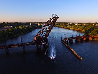
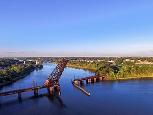
The Crook Point Bascule Bridge is a defunct Scherzer rolling lift railway bridge which spans the Seekonk River, connecting the city of Providence, Rhode Island, to the city of East Providence. Stuck in the open position since its abandonment in 1976, it is known to nearby residents as the "Stuck-Up Bridge" and has become somewhat of a local icon of urban decay. In 2022, the Providence Journal described the bridge as "a T-shirt-ready symbol of Providence's quirky evolution from industrial to creative hub."

The Providence, Warren and Bristol Railroad was a railroad in the state of Rhode Island that connected the city of Providence with Bristol, Rhode Island. The company was formed in 1854 by merging the Providence, Warren and Bristol Railroad Companies of Massachusetts and Rhode Island. The 14.1-mile line itself was completed on July 12, 1855.

The Blackstone Park Conservation District is a public, 45-acre woodland conservation area on the East Side of Providence, Rhode Island. It is run by the non-profit Blackstone Parks Conservancy in partnership with the Providence Parks Department. The park is situated on the west bank of the tidal Seekonk River, the northernmost part of Narragansett Bay tidewater. The park lies within the watershed and wildlife corridor of the Blackstone River Valley. Unlike many city parks, it is actively managed as a preserve for the purpose of providing habitats for wildlife and supporting a healthy ecosystem for native flora and fauna.

The East Providence Branch is a railroad line in Rhode Island and Massachusetts, in the United States. It connects Valley Falls, Rhode Island, to East Providence, Rhode Island, via South Attleboro, Massachusetts, and Pawtucket, Rhode Island. The branch was originally built by the Providence and Worcester Railroad (P&W) in 1874, connecting its main line to a coal dock in East Providence, and was 7 miles (11 km) in length. At East Providence, the branch also met the East Junction Branch of the Boston and Providence Railroad and the mainline of the Providence, Warren and Bristol Railroad. Built as a single-track railroad with bridges and the right-of-way prepared for future double-tracking, the line was fully double-tracked from 1892 to 1895; the second track was eventually removed.