Newport County is one of five counties located in the U.S. state of Rhode Island. As of the 2020 census, the population was 85,643. It is also one of the seven regions of Rhode Island. The county was created in 1703. Like all of the counties in Rhode Island, Newport County no longer has any governmental functions. All of those functions in Rhode Island are now carried out by the state government, or by the cities and towns of Rhode Island. Newport County is included in the Providence-Warwick, RI-MA Metropolitan Statistical Area, which is in turn constitutes a portion of the greater Boston-Worcester-Providence, MA-RI-NH-CT Combined Statistical Area.
Fall River is a city in Bristol County, Massachusetts, United States. Fall River's population was 94,000 at the 2020 United States census, making it the tenth-largest city in the state. It abuts the Rhode Island state line with Tiverton, RI to its south.
Little Compton is a coastal town in Newport County, Rhode Island, bounded on the south by the Atlantic Ocean, on the west by the Sakonnet River, on the north by the town of Tiverton, and on the east by the town of Westport, Massachusetts. The population was 3,589 as of 2022 Town Records. However, during the summer months the population nearly doubles due to the tourist aspect of the town.

Tiverton is a town in Newport County, Rhode Island, United States. The population was 16,359 at the 2020 census.

Aquidneck Island, officially known as Rhode Island, is an island in Narragansett Bay in the state of Rhode Island. The total land area is 37.8 sq mi (98 km2), which makes it the largest island in the bay. The 2020 United States Census reported its population as 60,109. The state of Rhode Island is named after the island; the United States Board on Geographic Names recognizes Rhode Island as the name for the island, although it is widely referred to as Aquidneck Island in the state and by the island's residents.
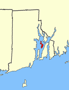
Prudence Island is the third-largest island in Narragansett Bay in the state of Rhode Island and part of the town of Portsmouth, Rhode Island, United States. It is located near the geographic center of the bay. It is defined by the United States Census Bureau as Block Group 3, Census Tract 401.03 of Newport County, Rhode Island. As of the 2010 census, the population was 278 people living on a land area of 14.43 km2 (5.57 sq mi).

The Mount Hope Bay raids were a series of military raids conducted by British troops during the American Revolutionary War against communities on the shores of Mount Hope Bay on May 25 and 31, 1778. The towns of Bristol and Warren, Rhode Island were significantly damaged, and Freetown, Massachusetts was also attacked, although its militia resisted British attacks more successfully. The British destroyed military defenses in the area, including supplies that had been cached by the Continental Army in anticipation of an assault on British-occupied Newport, Rhode Island. Homes as well as municipal and religious buildings were also destroyed in the raids.

Interstate 195 (I-195) is an auxiliary Interstate Highway running a combined 44.55 miles (71.70 km) in the US states of Rhode Island and Massachusetts. It travels from a junction with I-95 in Providence, Rhode Island, east to a junction with I-495 and Massachusetts Route 25 in Wareham, Massachusetts. It runs east–west and passes through the cities of Fall River, Massachusetts, and New Bedford, Massachusetts. The portion of I-195 in East Providence is also known as the East Providence Expressway.
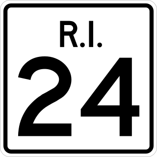
Route 24 is a freeway in the U.S. state of Rhode Island. It runs approximately 8 miles (13 km) from Route 114 in Portsmouth to Massachusetts Route 24 in Fall River, Massachusetts. Route 24 is the primary freeway access for the two towns in the southeastern corner of the state, Tiverton and Little Compton. Though on the mainland, they are isolated from the rest of the state by an arm of the Narragansett Bay. Because of this, the main freeway connection to Providence involves using Rhode Island Route 24, Massachusetts Route 24, and Interstate 195.

The Mount Hope Bridge is a two-lane suspension bridge spanning the Mount Hope Bay in eastern Rhode Island at one of the narrowest gaps in Narragansett Bay. The bridge connects the Rhode Island towns of Portsmouth and Bristol and is part of Route 114. Its towers are 285 feet (87 m) tall, the length of the main span is 1,200 feet (370 m), and it offers 135 feet (41 m) of clearance over high water. The total length of the bridge is 6,130 feet (1,870 m).

The Sakonnet River is a tidal strait in the state of Rhode Island which flows approximately 14 miles (23 km) between Mount Hope Bay and Rhode Island Sound. It separates Aquidneck Island from the eastern portion of Newport County.
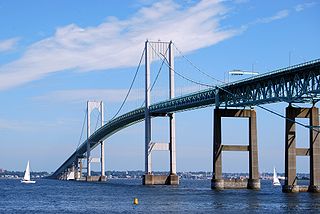
The Claiborne Pell Bridge, commonly known as the Newport Bridge, is a suspension bridge operated by the Rhode Island Turnpike and Bridge Authority that spans the East Passage of the Narragansett Bay in Rhode Island. The bridge, part of RI 138, connects the city of Newport on Aquidneck Island and the Town of Jamestown on Conanicut Island, and is named for longtime Rhode Island U.S. senator Claiborne Pell who lived in Newport. The Pell Bridge is in turn connected to the mainland by the Jamestown Verrazzano Bridge.

Route 138 is a numbered State Highway running 48.3 miles (77.7 km) in Rhode Island. It is the longest state numbered route in Rhode Island, and the second longest highway after US 1. Route 138 begins in Exeter at the Connecticut state line in the west and runs to the Massachusetts state line in Tiverton in the east, and is the only state-numbered route to completely cross Rhode Island. Route 138 also keeps the same route number on the other side of both state lines.
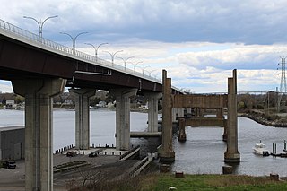
Sakonnet River Bridge is a four-lane bridge spanning the Sakonnet River in eastern Rhode Island. The bridge carries RI 24 and RI 138 between the communities of Portsmouth and Tiverton, Rhode Island. The current bridge is a box girder bridge that opened in 2012 at a cost of $120 million (USD). The previous bridge was a truss bridge that was built in 1956 and demolished in 2012 due to structural deficiencies. The truss bridge had previously served as a replacement for the Stone Bridge, about 0.8 miles (1.3 km) to the south.

The South Coast of Massachusetts is the region of southeastern Massachusetts consisting of the southern part of Bristol and Plymouth counties, bordering Buzzards Bay, and includes the cities of Fall River, New Bedford, the southeastern tip of East Taunton and nearby towns. The Rhode Island towns of Tiverton and Little Compton, located in Newport County, are often included within the South Coast designation due to regional similarities with adjacent communities.

Mount Hope Bay is a tidal estuary located at the mouth of the Taunton River on the Massachusetts and Rhode Island border. It is an arm of Narragansett Bay. The bay is named after Mount Hope, a small hill located on its western shore in what is now Bristol, Rhode Island. It flows into the East Passage of Narragansett Bay and also the Sakonnet River. Mount Hope Bay has played an important role to the history of the area, from pre-colonial times to the present. While many years of sewage and industrial pollution have severely degraded the quality of the shallow waters of the bay, there are currently major efforts underway to clean up and restore it.
East Bay Media Group, registered as Phoenix-Times Publishing Company, is a publisher based in Bristol, Rhode Island, United States, and owner of seven weekly newspapers in eastern Rhode Island and southeastern Massachusetts.
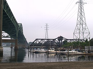
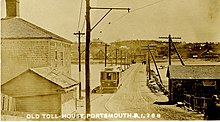
The Sakonnet River rail bridge was a swing bridge that spanned the Sakonnet River between Portsmouth and Tiverton, Rhode Island, and provided the only rail link between Aquidneck Island and the mainland. It was closed in 1988 and removed in 2006–07

Fall River granite is a Precambrian bedrock underlying the City of Fall River, Massachusetts and surrounding areas along the eastern shores of Narragansett Bay. It was formed 600 million years ago, as part of the Avalon terrane.

Israel T. Almy (1892-1963) was an American architect from Fall River, Massachusetts.