
The Narragansett people are an Algonquian American Indian tribe from Rhode Island. The tribe was nearly landless for most of the 20th century, but it worked to gain federal recognition and attained it in 1983. It is officially the Narragansett Indian Tribe of Rhode Island and is made up of descendants of tribal members who were identified in an 1880 treaty with the state.

Narragansett Bay is a bay and estuary on the north side of Rhode Island Sound covering 147 mi2 (380 km2), 120.5 mi2 (312 km2) of which is in Rhode Island. The Bay forms New England's largest estuary, which functions as an expansive natural harbor and includes a small archipelago. Small parts of it extend into Massachusetts.
Aquidneck Island, officially Rhode Island, is an island in Narragansett Bay and in the state of Rhode Island, which is named after the island. The total land area is 97.9 km2 (37.8 sq mi), which makes it the largest island in the bay. The 2000 United States Census reported its population as 60,870.
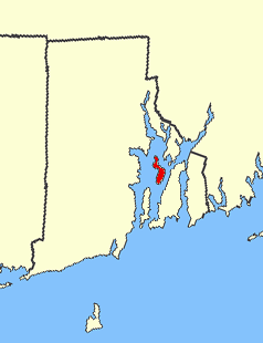
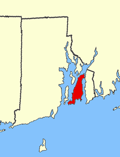
Prudence Island is the third-largest island in Narragansett Bay in the state of Rhode Island and part of the town of Portsmouth, Rhode Island United States. It is located near the geographical center of the bay. It is defined by the United States Census Bureau as Block Group 3, Census Tract 401.03 of Newport County, Rhode Island. As of the 2000 census, the population was 88 people living on a land area of 14.43 km².
Narragansett Bay divides the state of Rhode Island into two parts. The term East Bay refers to communities on the east side of the bay, including Bristol, Warren, Barrington, Tiverton, Little Compton, Newport, Middletown, Portsmouth and Jamestown. The term West Bay refers to communities on the west side of the bay, such as Warwick, Cranston and East Greenwich. Jamestown and the towns on Aquidneck Island are sometimes known as "The Islands" along with Block Island.

Davisville, Rhode Island is a village in the town of North Kingstown in the U.S. state of Rhode Island that was formerly the home of the Davisville Naval Construction Battalion Center, which housed the United States Navy's SeaBees.

Goat Island is a small island in Narragansett Bay and is part of the city of Newport, Rhode Island, U.S. The island is connected to the Easton's Point neighborhood via a causeway bridge. It is home to the Newport Harbor Light (1842), residences, a restaurant, event space, and hotel. It was also home to several military forts and to the U.S. Naval Torpedo Station, and was the site of the attacks on HMS St John and HMS Liberty.

Patience Island lies off the northwest coast of Prudence Island in the town of Portsmouth, Rhode Island. It has a land area of 0.33 sq mi, making it the fourth-largest island in Narragansett Bay.

Hog Island is an island in Narragansett Bay in Rhode Island. It lies at the entrance to the harbor of Bristol and is part of the town of Portsmouth. The 60 ft (18 m) tall Hog Island Shoal Lighthouse stands off the south end, warning ships of the dangerous shoals around the island. It has a land area of approximately 0.3 sq mi, making it the fifth-largest island in Narragansett Bay. It is home to a small summer vacation colony, with no regular year-round residents, and there are approximately 100 homes on it.
The Gordon School is a coeducational, independent school located in East Providence, Rhode Island. Students are educated from nursery through eighth grade. It is located on a 12-acre (49,000 m2) site.

Whale Rock or Submarine Rock is the smallest island in Narragansett Bay in Rhode Island. It is located in the West Passage of the bay in Narragansett, Washington County, Rhode Island, west of the Beavertail area on Conanicut Island. The island received its names because it is shaped like a whale's back or a submarine's bow. It was responsible for numerous shipwrecks prior to the construction of a lighthouse. Whale Rock Light was built on the rock in 1882; it was destroyed by the 1938 New England hurricane, which also claimed the life of keeper Walter Eberle. Part of the lighthouse's foundation can still be seen.
Coasters Harbor Island is a 92-acre (370,000 m2) island in Narragansett Bay, Newport, Rhode Island. The island is home to the Naval War College (NWC), an education and research institution of the United States Navy that specializes in developing ideas for naval warfare and passing them along to officers of the Navy.
Cornelius Island is a small uninhabited island in Wickford Harbor, Narragansett Bay, Wickford, Rhode Island.
Greene Island is a small island in Narragansett Bay, Warwick, Rhode Island. The island was named after Captain John Greene who purchased the island in 1642 from Native Americans as part of a larger purchase of 660 acres around Occupaspatuxet Cove. Occupaspatuxet means where “meadows cut through by a river,” and the area was also known as Greene's Hold. Chief Miantonomi was one of the Indian witnesses on the deed to Greene, which referenced the "little island." The Greenes were followers of Samuel Gorton, a radical Christian philosopher and theologian, who sought refuge in the Warwick area. Greene Island features shallow tidal flats and marsh grasses.
Rabbitt Island is a small island in Wickford Harbor, Narragansett Bay, Wickford, Rhode Island. Roger Williams received the island from Chief Canonicus' wife as a gift for a place to raise his goats. Richard Smith, who built Smith's Castle, later owned the island.

Rose Island is an 18.5-acre (7.5 ha) island in Narragansett Bay off Newport, Rhode Island, United States. It is allegedly named "Rose Island" because at low tide the island appears to be shaped like a rose. The Island is only accessible by boat. The island and its lighthouse are run by the private, non-profit Rose Island Lighthouse Foundation.
Rock Island is an island in Narragansett Bay in the U.S. state of Rhode Island.
Davol Square is a historic public square in central Providence, Rhode Island. It is located at the intersection of Point Street and Eddy Street in the Upper South Providence neighborhood, in the middle of the Jewelry District.
The Narragansett Runestone, also known as the Quidnessett Rock, is a 2.5 tonne slab of metasandstone located in Rhode Island, United States. It is inscribed with two rows of symbols, which some have indicated resemble ancient Runic characters.

Bold Point is an area of East Providence, Rhode Island protruding into the Providence River. It was home to Providence Dry Dock and Marine Railway Co. around the turn of the 20th century, and today is home to Bold Point Park.
