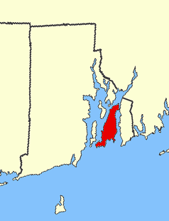
Potowomut is an isolated neighborhood and a peninsula in Warwick, Rhode Island. It is bordered by the Town of East Greenwich to the northwest, and by North Kingstown to the southeast. Greenwich Bay surrounds all other sides.

Point Judith is a village and a small cape, on the coast of Narragansett, Rhode Island, on the western side of Narragansett Bay where it opens out onto Rhode Island Sound. It is the location for the year-round ferry service that connects Block Island to the mainland and contains the fishing hamlet of Galilee, Rhode Island.
Aquidneck Island, officially Rhode Island, is an island in Narragansett Bay and in the State of Rhode Island and Providence Plantations, which is partially named after the island. The total land area is 97.9 km2 (37.8 sq mi), which makes it the largest island in the bay. The 2000 United States Census reported its population as 60,870.
Conanicut Island is the second largest island in Narragansett Bay in the US state of Rhode Island. It is connected on the east by the Claiborne Pell Bridge to Newport on Aquidneck Island, and on the west by the Jamestown-Verrazano Bridge to North Kingstown on the mainland. The island comprises the town of Jamestown, Rhode Island. The United States Census Bureau reported a land area of 24.46 km2 (9.44 sq mi) and a population of 5,622 as of the 2000 census.
Prudence Island is the third-largest island in Narragansett Bay in the state of Rhode Island and part of the town of Portsmouth, Rhode Island. It is located near the geographical center of the bay. It is defined by the United States Census Bureau as Block Group 3, Census Tract 401.03 of Newport County, Rhode Island. As of the 2000 census, the population was 88 people living on a land area of 14.43 km².
Narragansett Bay divides the state of Rhode Island into two parts. The term East Bay refers to communities on the east side of the bay, including Bristol, Warren, Barrington, Tiverton, Little Compton, Newport, Middletown, Portsmouth and Jamestown. The term West Bay refers to communities on the west side of the bay, such as Warwick, Cranston and East Greenwich. Jamestown and the towns on Aquidneck Island are sometimes known as "The Islands" along with Block Island.

Edgewood is located in eastern Cranston, Rhode Island. It borders Warwick to the southwest, Providence to the north, and Narragansett Bay to the east. To the south it borders Pawtuxet Village.

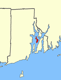
Apponaug is a neighborhood in central Warwick, Rhode Island, United States, situated on Apponaug Cove, a tributary to Greenwich Bay and nearby Narragansett Bay. The name Apponaug is a derivation of the Narragansett Indian word for "place of oysters". Indeed, Apponaug Cove holds one of the richest shellfish beds in the United States and was densely populated by the Narragansett people for many centuries prior to the arrival of European settlers.
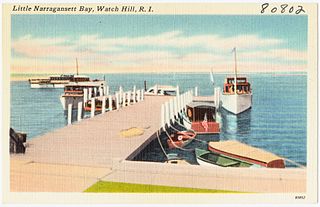
Little Narragansett Bay is an inlet of the Atlantic Ocean and an estuary of the Pawcatuck River on the Rhode Island-Connecticut state line. It is sheltered by a curving peninsula, known as Napatree Point.

The Pawtuxet River is a river in the U.S. state of Rhode Island. It flows 12.3 miles (19.8 km) and drains a watershed of 231.6 square miles (600 km2). There are four dams along the river's length.

Patience Island lies off the northwest coast of Prudence Island in the town of Portsmouth, Rhode Island. It has a land area of 0.33 sq mi, making it the fourth-largest island in Narragansett Bay.

Gould Island lies east of Conanicut Island in Narragansett Bay in the U.S. state of Rhode Island. It is a part of the town of Jamestown, Rhode Island, and has a land area of 55.3 acres (22.4 ha).
Dyer Island is an island in Narragansett Bay in Rhode Island, United States. It lies off the west coast of Aquidneck Island and is part of Melville CDP, which itself is part of the town of Portsmouth. The island lies between Melville and Prudence Island and is uninhabited and has a land area of 0.12 km² and is only 13 feet above sea level.
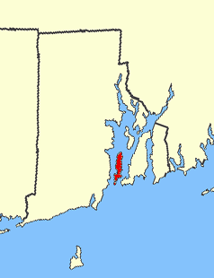
Chepiwanoxet is a neighborhood in Warwick, Rhode Island, with an island peninsula in Greenwich Bay, an arm of Narragansett Bay. The neighborhood straddles the Amtrak railroad lines, which lies just east of and parallel to the Post Road. Its boundaries are Neptune Street to the North, Alger Avenue to the South, Post Road to the West, and Greenwich Bay to the East. Chepiwanoxet Way, an underpass beneath the Amtrak lines, now serves as the only street access in and out of the neighborhood.
Coasters Harbor Island is a 92-acre (370,000 m2) island in Narragansett Bay, Newport, Rhode Island. The island is home to the Naval War College (NWC), an education and research institution of the United States Navy that specializes in developing ideas for naval warfare and passing them along to officers of the Navy.
Starvegoat Island was a small island in the Providence River, Providence, Rhode Island. The island also appears as "Sunshine Island" on the 1927 North American datum map produced by the US Army Corps of Engineers 30th Battalion. The island was the southeastern most point in the city of Providence. During the 19th and early 20th centuries, it was known for its oystering. It was located off the coast of Fields Point until the passage between them was filled in during the 1950s and 1960s when the area was used as a land fill. The approximate location of the island is now an educational center for Save the Bay, and one of its features is the re-creation of a natural coastal buffer zone.

Pontiac is a historic village in Warwick, Rhode Island and Cranston, Rhode Island.