
Narragansett Bay is a bay and estuary on the north side of Rhode Island Sound covering 147 square miles (380 km2), 120.5 square miles (312 km2) of which is in Rhode Island. The bay forms New England's largest estuary, which functions as an expansive natural harbor and includes a small archipelago. Small parts of the bay extend into Massachusetts.

Point Judith is a village and a small cape, on the coast of Narragansett, Rhode Island, United States, on the western side of Narragansett Bay where it opens out onto Rhode Island Sound. It is the location for the year-round ferry service that connects Block Island to the mainland and contains the fishing hamlet of Galilee.
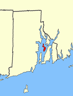
Prudence Island is the third-largest island in Narragansett Bay in the state of Rhode Island and part of the town of Portsmouth, Rhode Island, United States. It is located near the geographic center of the bay. It is defined by the United States Census Bureau as Block Group 3, Census Tract 401.03 of Newport County, Rhode Island. As of the 2010 census, the population was 278 people living on a land area of 14.43 km2 (5.57 sq mi).

The Colony of Rhode Island and Providence Plantations was one of the original Thirteen Colonies established on the east coast of America, bordering the Atlantic Ocean. It was founded by Roger Williams. It was an English colony from 1636 until 1707, and then a colony of Great Britain until the American Revolution in 1776, when it became the State of Rhode Island and Providence Plantations. Its official name according to the Royal Charter of 1663 is the Governor and Company of the English Colony of Rhode-Island and Providence Plantations, in the Narragansett Bay, New England, in America.

The Pawcatuck River is a river in the US states of Rhode Island and Connecticut flowing approximately 34 miles (55 km). There are eight dams along the river's length. USS Pawcatuck was named after the river.

Riverside is a neighborhood in the city of East Providence in the U.S. state of Rhode Island. Despite not being an incorporated city, Riverside has its own zip code, 02915, and is an acceptable mailing address according to the United States Postal Service. Riverside has a population of approximately 20,000 people.

The Sakonnet River is a tidal strait in the state of Rhode Island which flows approximately 14 miles (23 km) between Mount Hope Bay and Rhode Island Sound. It separates Aquidneck Island from the eastern portion of Newport County.

Hope Island is a 91-acre (0.368 km2) island located in Narragansett Bay in the State of Rhode Island. It is part of the Narragansett Bay National Estuarine Research Reserve, along with nearby Prudence Island and Patience Island, and home to colonial wading birds during their nesting season of spring and summer.

Patience Island lies off the northwest coast of Prudence Island in the town of Portsmouth, Rhode Island, United States. It has a land area of 0.33 sq mi, making it the fourth-largest island in Narragansett Bay. Aside from a single 600-square foot house, which is disconnected from the state electrical grid, Patience Island is otherwise uninhabited.
Dyer Island is an island in Narragansett Bay in Rhode Island, United States. It lies off the west coast of Aquidneck Island and is part of Melville CDP, which itself is part of the town of Portsmouth. The island lies between Melville and Prudence Island and is uninhabited and has a land area of 0.12 km² and is only 13 feet above sea level.

Mount Hope Bay is a tidal estuary located at the mouth of the Taunton River on the Massachusetts and Rhode Island border. It is an arm of Narragansett Bay. The bay is named after Mount Hope, a small hill located on its western shore in what is now Bristol, Rhode Island. It flows into the East Passage of Narragansett Bay and also the Sakonnet River. Mount Hope Bay has played an important role to the history of the area, from pre-colonial times to the present. While many years of sewage and industrial pollution have severely degraded the quality of the shallow waters of the bay, there are currently major efforts underway to clean up and restore it.
The Pettaquamscutt River is a tidal extension of the Mattatuxet River in the U.S. state of Rhode Island. It flows approximately 6.3 miles (10.1 km). There are no dams along the river's length.

Chepiwanoxet is a neighborhood in Warwick, Rhode Island, with an island peninsula in Greenwich Bay, an arm of Narragansett Bay. The neighborhood straddles the Amtrak railroad lines, which lies just east of and parallel to the Post Road. Its boundaries are Neptune Street to the North, Alger Avenue to the South, Post Road to the West, and Greenwich Bay to the East. Chepiwanoxet Way, an underpass beneath the Amtrak lines, now serves as the only street access in and out of the neighborhood.

Whale Rock or Submarine Rock is the smallest island in Narragansett Bay in Rhode Island. It is located in the West Passage of the bay in Narragansett, Washington County, Rhode Island, west of the Beavertail area on Conanicut Island. The island received its names because it is shaped like a whale's back or a submarine's bow. It was responsible for numerous shipwrecks prior to the construction of a lighthouse. Whale Rock Light was built on the rock in 1882; it was destroyed by the 1938 New England hurricane, which also claimed the life of keeper Walter Eberle. Part of the lighthouse's foundation can still be seen.

Starvegoat Island was a small island in the Providence River, Providence, Rhode Island. The island also appears as "Sunshine Island" on the 1927 North American datum map produced by the US Army Corps of Engineers 30th Battalion. The island was the southeasternmost point in the city of Providence. During the 19th and early 20th centuries, it was known for its oystering. It was located off the coast of Fields Point until the passage between them was filled in during the 1950s and 1960s when the area was used as a land fill. The approximate location of the island is now an educational center for Save the Bay, and one of its features is the re-creation of a natural coastal buffer zone.
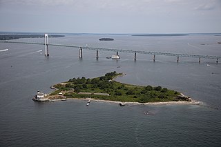
Rose Island is an 18.5-acre (7.5 ha) island in Narragansett Bay off Newport, Rhode Island, United States. It is allegedly named "Rose Island" because at low tide the island appears to be shaped like a rose. The Island is only accessible by boat. The island and its lighthouse are run by the private, non-profit Rose Island Lighthouse Foundation.

Washington County, known locally as South County, is a county located in the U.S. state of Rhode Island. As of the 2020 census, the population was 129,839. Rhode Island counties have no governmental functions other than as court administrative boundaries, which are part of the state government.

The Hannah Robinson Tower is a 40 feet (12 m) tall wooden tower at the interchange between U.S. Route 1 and Route 138 in the community of South Kingstown, South County, Rhode Island. The tower was built in 1938 by the Civilian Conservation Corps and was rebuilt in 1988 using the same pillars. The structure is named after Hannah Robinson (1746–1773), a colonial Rhode Island resident and daughter of a wealthy Narragansett society man, Rowland Robinson. Hannah fell in love with a local teacher, Peter Simon, but the relationship was deemed unsuitable by her father. Despite her father's disapproval, Hannah Robinson married her suitor and lived in Providence, Rhode Island. The family became estranged from Robinson, who was enveloped in poverty, leading to a fatal decline. Robinson's father ended his opposition and left his community of Boston Neck to bring Hannah home. As Rowland Robinson brought his daughter home, she requested a chance to visit nearby McSparran Hill, where she considered a view of her homeland. Robinson died soon after.

The first USS Cero (SP-1189) was a United States Navy patrol vessel in commission from 1917 to 1918.
