41°56′00″N71°23′22″W / 41.9332°N 71.3894°W
Contents

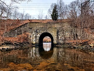
The Millers River is a river in the eastern section of the U.S. state of Rhode Island. It flows approximately 3 km (2 mi). There are no dams along the river's length.
41°56′00″N71°23′22″W / 41.9332°N 71.3894°W
The Millers River is a river in the eastern section of the U.S. state of Rhode Island. It flows approximately 3 km (2 mi). There are no dams along the river's length.
The river rises from an unnamed pond, now known as Friars' Cirque, Ea. along Bear Hill Road in Cumberland and flows due south to its confluence with Abbott Run at Robin Hollow Pond.
Below is a list of all crossings over the Millers River. The list starts at the headwaters and goes downstream.
The Millers River has no named tributaries, though it has many unnamed streams that also feed it.

The Pawcatuck River is a river in the US states of Rhode Island and Connecticut flowing approximately 34 miles (55 km). There are eight dams along the river's length. USS Pawcatuck was named after the river.
The Beaver River is a river in the U.S. state of Rhode Island. It flows approximately 11.0 miles (17.7 km). There are three dams along the river's length. The river is also famous locally for its trout fishing in the spring.

The Wood River is a river in the U.S. states of Connecticut and Rhode Island. It flows approximately 25 miles (40 km) and is a major tributary of the Pawcatuck River. There are eight dams along the river's length.
The Sevenmile River or Seven Mile River is a river which flows through U.S. states of Massachusetts and Rhode Island. It flows approximately 9.8 miles (15.8 km).
The Saugatucket River is a river in the U.S. state of Rhode Island. It flows approximately 13 km (8 mi). There are three dams along the river's length.
The Runnins River is a river in the U.S. states of Massachusetts and Rhode Island. It flows approximately 14 km (9 mi).
The Pettaquamscutt River is a tidal extension of the Mattatuxet River in the U.S. state of Rhode Island. It flows approximately 6.3 miles (10.1 km). There are no dams along the river's length.
The Mattatuxet River is a river in the U.S. state of Rhode Island. It flows approximately 3 km (2 mi). There are two dams along the river's length.
The Maskerchugg River is a river in the U.S. state of Rhode Island. It flows approximately 4 miles (6.4 km).
The Maiford River is a river in the U.S. state of Rhode Island. It flows approximately 1 km (0.6 mi). There are no dams along the river's length.
The Maidford River is a river in the U.S. state of Rhode Island. It flows 4.1 miles (6.6 km). There is one dam along the river's length.
The Hunt River is a river in the U.S. state of Rhode Island. It flows approximately 11 km (7 mi). There is a small stone dam just upstream from the Davisville Road bridge that powered a woolen mill active in the period 1811–1924.

The Green Fall River is a river in the U.S. states of Connecticut and Rhode Island. It flows approximately 13 km (8 mi).
The Congdon River is a river in the U.S. state of Rhode Island, in the Big River State Management Area and immediately south. It flows approximately 3 km (2 mi). There are three dams along the river's length: at Rathbon Pond, Money Swamp Pond, and at Millbrook Pond. The river's crossing at Congdon Mill Road is the former site of a grist mill and later a sawmill, and is named after Joseph Congdon, the mill's owner.
The Chipuxet River is a river in the U.S. state of Rhode Island. It flows approximately 8.5 miles (13.7 km). There are two dams along the river's length.
The Chepachet River is a river in the U.S. state of Rhode Island. It flows 5.2 miles (8.4 km). There are eight dams along the river's length.
The Carr River is a river in Kent County in the U.S. state of Rhode Island. It flows approximately 6 km (4 mi). There are three dams along the river's length.
The Big River is a river in the U.S. state of Rhode Island. It flows 6.8 miles (10.9 km). There are no dams along the river's length.
Abbott Run is a de facto river in the U.S. state of Massachusetts and Rhode Island. It flows approximately 10 miles (16 km).
Wilde River is a river in Seekonk, Massachusetts and Pawtucket, Rhode Island. It begins at Bittersweet Pond in Seekonk and flows 5.2 miles to its confluence with the Ten Mile River in Pawtucket.