Related Research Articles

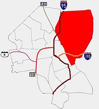
Route 15 is a state highway in the U.S. states of Rhode Island and Massachusetts. The highway runs 8.3 miles (13.4 km) from U.S. Route 44 in North Providence, Rhode Island east through Pawtucket to the Massachusetts state line, where the highway continues for 0.23 miles (0.37 km) to Route 152 in Seekonk.

Route 114 is a 45.7-mile-long (73.5 km) numbered state highway in the U.S. state of Rhode Island. It connects the city of Newport to the city of Woonsocket. Route 114 was a major north–south artery for its entire length until the arrival of the Interstate Highway System. It is still a major commercial corridor on Aquidneck Island and in northern Rhode Island.

The Seekonk River is a tidal extension of the Providence River in the U.S. state of Rhode Island. It flows approximately 5 km (3 mi). The name may be derived from an Algonquian word for skunk or for black goose. The river is home to the Brown University men's rowing team, India Point Park, Blackstone Park Conservation District, Crook Point Bascule Bridge, Narragansett Boat Club, Swan Point Cemetery, and the Bucklin Point waste-water treatment facility. The River is listed by the Rhode Island Department of Environmental Management as an impaired waterway.

The Barrington River is a tidal extension of Runnins River in the U.S. states of Rhode Island and Massachusetts. It flows approximately 6 km (4 mi). There are no dams along the river's length.

The Ten Mile River is a river within the U.S. states of Massachusetts and Rhode Island. It flows approximately 22 miles (35 km) and drains a watershed of 54 square miles (140 km2).

Blackstone is a predominantly residential neighborhood in Providence, Rhode Island. It is in the northeast corner of the city and is bounded to the south and west by Lloyd Avenue and Hope Street respectively. It is one of six neighborhoods comprising the East Side of Providence.
The East Side is a collection of neighborhoods in the eastern part of the city of Providence, Rhode Island. It officially comprises the neighborhoods of Blackstone, Hope, Mount Hope, College Hill, Wayland, and Fox Point.
The Sevenmile River or Seven Mile River is a river which flows through U.S. states of Massachusetts and Rhode Island. It flows approximately 9.8 miles (15.8 km).
The Saugatucket River is a river in the U.S. state of Rhode Island. It flows approximately 13 km (8 mi). There are three dams along the river's length.
The Runnins River is a river in the U.S. states of Massachusetts and Rhode Island. It flows approximately 14 km (9 mi).
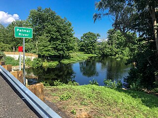
The Palmer River is a river in the U.S. states of Massachusetts and Rhode Island. It flows approximately 17 km (11 mi).
The Maskerchugg River is a river in the U.S. state of Rhode Island. It flows approximately 4 miles (6.4 km).
The Chepachet River is a river in the U.S. state of Rhode Island. It flows 5.2 miles (8.4 km). There are eight dams along the river's length.
Abbott Run is a de facto river in the U.S. state of Massachusetts and Rhode Island. It flows approximately 10 miles (16 km).

Route 152 is a state highway in the U.S. states of Rhode Island and Massachusetts. The highway begins at U.S. Route 1A and Route 114 in East Providence, Rhode Island. After crossing into Massachusetts, Route 152 runs 14.8821 miles (23.9504 km) through Seekonk, Attleboro, and North Attleboro to US 1 in Plainville.

Slater Park is the oldest and largest public park in Pawtucket, Rhode Island. The park is named after Samuel Slater, a famous American industrialist who constructed America's first water-powered textile mill in Pawtucket. The park lies on the banks of the beautiful Ten Mile River and features the 1685 Daggett House, the oldest house in Pawtucket. The park was added to the National Register of Historic Places in 1976. It also features an original Looff Carousel.

Coles Brook is a small stream that begins east of Pine Street in Rehoboth, Massachusetts, and flows in a southwest direction to Central Pond and the James V. Turner Reservoir and the on the border of Seekonk, Massachusetts, and East Providence, Rhode Island. It is a tributary of the Ten Mile River.
Blageddy Stream is a small brook in Slater Park in Pawtucket, Rhode Island. It connects the Slater Park Duck Pond, Friendship Gardens Pond, and the Blageddy Swamp to the Ten Mile River. Originally, the Blaggeddy Stream was a much larger Swamp before the creation of the park. The water that was there was routed into a narrow channel, which is the Blageddy Stream that is there today. The brook is formed by two channels. One flows north out of Friendship Gardens. The other flows south out of the Blaggeddy Swamp. They meet in a culvert and enter the Duck Pond, before flowing east into the Ten Mile River.
Bucklin Brook is a brook in Pawtucket, Rhode Island. It is 3 miles long and was at one time the source of drinking water for the city from a reservoir that was located at present day McCoy Stadium. The upper portion of the stream up to the stadium was buried in the 1930s to make room for development. The lower portion from the stadium to its mouth was buried in the 1960s because of an outbreak of polio. The brook still flows under the city.

William R. Walker & Son was an American architectural firm in Providence, Rhode Island, active during the years 1881 to 1936. It included partners William Russell Walker (1830–1905), William Howard Walker (1856–1922) and later William Russell Walker II (1884–1936).
References
- Maps from the United States Geological Survey
41°51′58″N71°20′28″W / 41.866°N 71.341°W
| | This Bristol County, Massachusetts geography–related article is a stub. You can help Wikipedia by expanding it. |