Three Mile River

Last updated
View of Three Mile River in winter Three Mile River 1-10-10.jpg
View of Three Mile River in winter
1893 Map of Three Mile River Three Mile River (Massachusetts) map.jpg
1893 Map of Three Mile River

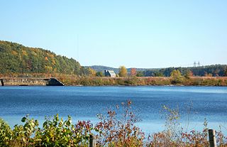
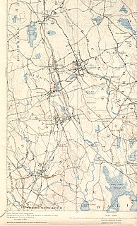
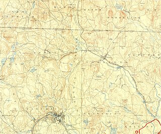
The Three Mile River or Threemile River [1] is a river in Bristol County, Massachusetts. It is formed by the junction of the Rumford and Wading rivers in the town of Norton. [2] It flows in a southeasterly direction for 13.5 miles (21.7 km) [3] through the towns of Norton, Taunton and Dighton, where it joins the Taunton River. [4]

River Natural flowing watercourse

A river is a natural flowing watercourse, usually freshwater, flowing towards an ocean, sea, lake or another river. In some cases a river flows into the ground and becomes dry at the end of its course without reaching another body of water. Small rivers can be referred to using names such as stream, creek, brook, rivulet, and rill. There are no official definitions for the generic term river as applied to geographic features, although in some countries or communities a stream is defined by its size. Many names for small rivers are specific to geographic location; examples are "run" in some parts of the United States, "burn" in Scotland and northeast England, and "beck" in northern England. Sometimes a river is defined as being larger than a creek, but not always: the language is vague.

Bristol County, Massachusetts County in the United States

Bristol County is a county in the Commonwealth of Massachusetts. As of the 2010 census, the population was 548,285. The county seat is Taunton. Some governmental functions are performed by the Commonwealth of Massachusetts, others by the county, and others by local towns and cities. See administrative divisions of Massachusetts. The property deed records are kept in Taunton, Attleboro, Fall River, and New Bedford.

The Rumford River is a small river in southeastern Massachusetts, United States, that is a tributary of the Threemile River in the Taunton River watershed. The Rumford River, 23.1 kilometres (14.4 mi) long, begins within the town of Foxborough and flows south through Mansfield to the Norton Reservoir, within the town of Norton, then continues to its confluence with the Wading River to form the Threemile River.

Contents

On August 25, 2008, the Three Mile Watershed was designated an Area of Critical Environmental Concern (ACEC) by the Massachusetts Department of Conservation and Recreation (DCR). The ACEC designation imparts certain protections and restrictions within a designated area relating to new development and other human activities. [5]

The Massachusetts Area of Critical Environmental Concern (ACEC) Program is a list of state-designated places within the Commonwealth that receive special attention due to their natural and cultural resources. The program was established in 1975 and includes a list of thirty ACECs covering over 268,000 acres in seventy six communities throughout the state. The ACEC Program is administered by the Department of Conservation and Recreation (DCR) on behalf of the Secretary of Energy and Environmental Affairs.

See also

Related Research Articles

Taunton River river in Massachusetts, United States

The Taunton River, is a river in southeastern Massachusetts in the United States. It arises from the confluence of the Town River and Matfield River, in the town of Bridgewater. From there it meanders through the towns of Halifax, Middleborough and Raynham, through the city of Taunton for which it is named, the towns of Berkley, Dighton, Somerset, and the Assonet section of Freetown, to Fall River where it joins Mount Hope Bay, an arm of Narragansett Bay.

Assonet River river in the United States of America

The Assonet River is located in Bristol County, Massachusetts. It flows 7.4 miles (11.9 km) in a westerly direction through Freetown and joins the Taunton River near Assonet Neck in Berkley, Massachusetts.

Segreganset River river in the United States of America

The Segreganset River is a small river in Bristol County, Massachusetts that flows 9.6 miles (15.4 km) in a southeasterly direction through Taunton and Dighton into the Taunton River. Named tributaries include the Maple Swamp, Poppasquash Swamp, Sunken Brook and Cedar Swamp.

The Cotley River is a small river in Taunton and Berkley, Massachusetts that is a tributary of the Taunton River. It flows approximately 5.8 miles (9.2 km) in a northwesterly direction from the southeast part of Taunton near Seekell Street to Barstows Pond near the village of East Taunton where it joins the Taunton River.

Taunton River Watershed

The Taunton River watershed or Taunton River basin is made up of 562 square miles (1,500 km2) of rivers, lakes, ponds, streams, and wetlands in southeastern Massachusetts, USA. It is the second largest watershed in the state. Also, it is a significant part of a much larger multi-state watershed, the Narragansett Bay watershed.

Watson Pond lake of the United States of America

Watson Pond is a small freshwater lake within Watson Pond State Park, in Taunton, Massachusetts, USA. The lake is connected to Lake Sabbatia and much of its coastline is forested. The lake is open to the public for swimming and ice fishing.

The Hockomock Swamp is a vast wetland encompassing much of the northern part of southeastern Massachusetts. This 16,950-acre (6,859 ha) land is considered the largest freshwater swamp in the state. It acts as a natural flood control mechanism for the region.

Forge River river in the United States of America

The Forge River is a 5.1-mile-long (8.2 km) river in the town of Raynham in southeastern Massachusetts. It is a tributary of the Taunton River. It rises from Gushee Pond near Interstate 495 and flows northwest through Titicut Swamp, then turns southwest for the rest of its course. It flows through Hewitt Pond, passes the neighborhood of Tracy Corner, then continues through Johnson Pond and the village of Raynham Center to its junction with the Taunton River.

The Wading River is a 13.1-mile-long (21.1 km) river in southeastern Massachusetts in the United States. It rises from Lake Miramichi in the town of Foxborough and flows southeast through Mansfield into the town of Norton, where it turns east, flows through Barrowsville Pond, and continues to its confluence with the Rumford River, forming the Three Mile River. The river is part of the Taunton River watershed.

Stillwater River (Nashua River tributary) tributary of the Nashua River in the United States of America

The Stillwater River is part of the Nashua River watershed. This river is part of the Massachusetts Water Resources Authority system that supplies drinking water to the greater Boston area.

Shumatuscacant River river in the United States of America

The Shumatuscacant River is an 8.8-mile-long (14.2 km) river running through Abington and Whitman, Massachusetts. It forms part of the Taunton River Watershed.

Canoe River river in the United States of America

The Canoe River is a river in southeastern Massachusetts. It is 14.4 miles (23.2 km) long and part of the Taunton River Watershed.

Squannacook River river in the United States of America

The Squannacook River is a 16.4-mile-long (26.4 km) river in northern Massachusetts. It is a tributary of the Nashua River and part of the Merrimack River watershed flowing to the Atlantic Ocean.

Weir Village, Massachusetts human settlement in United States of America

Weir Village is a village of the city of Taunton in Bristol County, Massachusetts, located about one mile south of the city center on the banks of the Taunton River, near the point where it becomes tidal. The village takes its name from fishing weirs which were placed across the Taunton River from pre-colonial times until the early 20th century, to catch herring. While much of the commercial part of the village lies on the west side of the river, along Weir Street , a dense residential area extends in an easterly direction across the river along Plain and Berkley Streets.

Weir River (Massachusetts) river in the United States of America

Weir River is a short stream and estuary that empties into Hingham Bay, part of Boston Harbor in Massachusetts, United States. The name is attributed to the location of a fishing weir in the stream. The river gives its name to a larger watershed and Weir River Farm, a park and nature reserve owned by The Trustees of Reservations.

Snake River (Massachusetts)

The Snake River is a small river in Bristol County, Massachusetts. It flows 4.0 miles (6.4 km) from Winnecunnet Pond to Lake Sabbatia in the northern part of Taunton, Massachusetts.

The Back River is a small tidal estuary in Bourne, Massachusetts on the eastern shore of Buzzards Bay. It lies just south of the Cape Cod Canal near the village of Monument Beach. It is separated from Buzzards Bay by Phinneys Harbor. The river's length is 2.1 miles (3.4 km).

The Cedar Swamp River is a small river in Lakeville, Massachusetts that flows 4.6 miles (7.4 km) in a northwesterly direction through the western part of the town to where it forms the Assonet River near the Freetown line, just south of the village of Myricks. It is a tributary of the Taunton River.

The Salisbury Plain River is a 4.7-mile-long (7.6 km) river in Plymouth County, Massachusetts that flows from the city of Brockton into the towns of West Bridgewater and East Bridgewater where it joins the Matfield River, a major tributary of the Taunton River.

References

  1. U.S. Geological Survey Geographic Names Information System: Threemile River
  2. ACEC Page
  3. U.S. Geological Survey. National Hydrography Dataset high-resolution flowline data. The National Map, accessed April 1, 2011
  4. USGS Maps
  5. ACEC Map, Mass DCR

Coordinates: 41°51′15″N71°06′28″W / 41.85427°N 71.10782°W / 41.85427; -71.10782

Geographic coordinate system Coordinate system

A geographic coordinate system is a coordinate system that enables every location on Earth to be specified by a set of numbers, letters or symbols. The coordinates are often chosen such that one of the numbers represents a vertical position and two or three of the numbers represent a horizontal position; alternatively, a geographic position may be expressed in a combined three-dimensional Cartesian vector. A common choice of coordinates is latitude, longitude and elevation. To specify a location on a plane requires a map projection.