Weir River (Massachusetts)

Last updated
Weir River
Weir River Massachusetts.jpg
Weir River at Hull looking east
Location
Country United States
Physical characteristics
Length4 mi (6.4 km)
Basin sizeHingham-Weir River Basin

Weir River is a short stream and estuary that empties into Hingham Bay, part of Boston Harbor in Massachusetts, United States. The name is attributed to the location of a fishing weir in the stream. [1] The river gives its name to a larger watershed and Weir River Farm, a park and nature reserve owned by The Trustees of Reservations. [2] [3]

Contents

Description

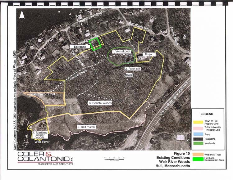
Weir River is formed at the confluence of Crooked Meadow River and Fulling Mill Brook in Hingham near the intersection of Free Street and Massachusetts Route 228 which are fed by Cushing Pond, Fulling Mill Pond, and the wetlands around Jacob's Meadow. The river flows north through Hingham and is joined by Tower Brook and Accord Brook in its first mile (1.6 km), then gradually turns northeast and travels another 1.4 miles (2.3 km) before being dammed to form Foundry Pond. [1] The dam marks the southern boundary of the estuary, which is one of 30 areas designated by the Commonwealth of Massachusetts as an Area of Critical Environmental Concern. [4] The estuary is split in two segments and extends over 1 mile (1.6 km) both east and north, forming the border between Hingham and the town of Hull to the north. On the west side of Weir River estuary lies World's End, another Trustees of Reservations park. The estuary reaches Hingham Bay at the north side of the World's End peninsula. Across the river from World's End are the Weir River Woods, owned by the town of Hull, with a parking lot owned by the Hull Land Conservation Trust. On the north side of the confluence with the Straits River, the Weir River Estuary Park is owned and jointly operated by the towns Hingham, Cohasset, and Hull. [5]

In 2005, the Commonwealth of Massachusetts designated the Weir River Watershed as "high stressed", [6] meaning the rate of dewatering, from seasonal low precipitation and water supply withdrawals, exceeds the rate of recharge, from natural rainfall, for extended periods during the year. The Weir River Watershed Association [7] is the non-profit organization charged with stewardship of the Weir River.

Related Research Articles

<span class="mw-page-title-main">Hull, Massachusetts</span> Town in Massachusetts, United States

Hull is a town in Plymouth County, Massachusetts, United States, located on a peninsula at the southern edge of Boston Harbor. Its population was 10,072 at the 2020 census. Hull is the smallest town by land area in Plymouth County and the fourth smallest in the state. However, its population density is nearly four times that of Massachusetts as a whole.

<span class="mw-page-title-main">Neponset River</span> River in eastern Massachusetts, United States

The Neponset River is a river in eastern Massachusetts in the United States. Its headwaters are at the Neponset Reservoir in Foxborough, near Gillette Stadium. From there, the Neponset meanders generally northeast for about 29 miles (47 km) to its mouth at Dorchester Bay between Quincy and the Dorchester section of Boston, near the painted gas tank.

<span class="mw-page-title-main">Department of Conservation and Recreation</span> State agency of the Commonwealth of Massachusetts

The Department of Conservation and Recreation (DCR) is a state agency of the Commonwealth of Massachusetts, situated in the Executive Office of Energy and Environmental Affairs. It is best known for its parks and parkways. The DCR's mission is "To protect, promote and enhance our common wealth of natural, cultural and recreational resources for the well-being of all." The agency is the largest landowner in Massachusetts.

<span class="mw-page-title-main">Alewife Brook Reservation</span>

Alewife Brook Reservation is a Massachusetts state park and urban wild located in Cambridge, Arlington, and Somerville. The park is managed by the state Department of Conservation and Recreation and was established in 1900. It is named for Alewife Brook, which was also historically known as Menotomy River, a tributary of the Mystic River.

<span class="mw-page-title-main">Satucket River</span> River in the United States of America

The Satucket River is 5.5-mile-long (8.9 km) river in southeastern Massachusetts within the Taunton River Watershed. It flows generally west from Robbins Pond in East Bridgewater, and into the Matfield River.

<span class="mw-page-title-main">Weir Hill</span>

Weir Hill Reservation is a 194-acre (0.79 km2) public park located in the town of North Andover, Massachusetts. The Trustees of Reservations owns and maintains the property.

<span class="mw-page-title-main">Ipswich River</span> River in the United States

Ipswich River is a small river in northeastern Massachusetts, United States. It held significant importance in early colonial migrations inland from the ocean port of Ipswich. The river provided safe harborage at offshore Plum Island Sound to early Massachusetts subsistence farmers, who were also fishermen. A part of the river forms town boundaries and divides Essex County, Massachusetts on the coast from the more inland Middlesex County. It is 35 miles (56 km) long, and its watershed is approximately 155 square miles (401 km2), with an estimated population in the area of 160,000 people.

<span class="mw-page-title-main">Bear Swamp</span>

Bear Swamp is a forested parkland in Ashfield, Massachusetts. The Trustees of Reservations owns and maintains the property.

<span class="mw-page-title-main">Weymouth Back River</span> River in Massachusetts, United States

The Weymouth Back River, sometimes called Back River, is a short, primarily tidal river in Hingham and Weymouth, Massachusetts, about 10 miles (16 km) south of Boston. It arises from a number of tributaries in ponds and swamps, most notably Whitmans Pond, flows northward, and empties into Hingham Bay.

<span class="mw-page-title-main">Quashnet River</span>

The Quashnet River, also known as Quoshnet River or Moonakis River, is a 5.1-mile-long (8.2 km) estuary in Falmouth, Massachusetts on Cape Cod. Its area is about 1-square-mile (2.6 km2).

<span class="mw-page-title-main">Shumatuscacant River</span>

The Shumatuscacant River is an 8.8-mile-long (14.2 km) river running through Abington and Whitman, Massachusetts. It forms part of the Taunton River Watershed.

<span class="mw-page-title-main">Browning Pond</span> Body of water

Browning Pond is located in Oakham and Spencer, Massachusetts. This 89-acre (360,000 m2) great pond forms the headwaters of the Seven Mile River. It is part of the Chicopee River Watershed.

<span class="mw-page-title-main">Brooks Woodland Preserve</span>

The Brooks Woodland Preserve is a 558-acre (226 ha) open space preserve located in Petersham, Massachusetts. The property, named after industrialist and diplomat James Wilson Brooks, is managed by the land conservation non-profit organization The Trustees of Reservations and offers 13 miles (21 km) of trails and primitive woods roads available for hiking, horseback riding, and cross country skiing. Second growth forest, overgrown farm fields, granite ledges, historic stone walls, creeks, and rolling hills characterize the preserve.

<span class="mw-page-title-main">Fore River (Massachusetts)</span>

Weymouth Fore River is a small bay or estuary in eastern Massachusetts and is part of the Massachusetts Bay watershed.

<span class="mw-page-title-main">Whitney and Thayer Woods</span>

Whitney and Thayer Woods is a nature reserve and forest located in Cohasset and Hingham, Massachusetts. The property is owned by The Trustees of Reservations. It is adjacent to the Weir River Farm, also owned by The Trustees, and Turkey Hill, a town-owned property managed by The Trustees.

<span class="mw-page-title-main">Weir River Farm</span>

Weir River Farm is a nature reserve located in Hingham, Massachusetts. The property is owned by The Trustees of Reservations. It is located adjacent to the Trustees-owned Whitney and Thayer Woods reservation, and the town-owned Turkey Hill property, which the Trustees manage.

<span class="mw-page-title-main">Bay Circuit Trail</span> Long-distance hiking trail in the United States

The Bay Circuit Trail and Greenway or Bay Circuit is a Massachusetts rail trail and greenway connecting the outlying suburbs of Boston from Plum Island in Newburyport to Kingston Bay in Duxbury, a distance of 200 miles (320 km).

<span class="mw-page-title-main">Hull Shore Drive and Nantasket Avenue</span> Historic district in Massachusetts, United States

Hull Shore Drive and Nantasket Avenue are a historic coastal parkway in Hull, Massachusetts. Nantasket Avenue, designated as part of Route 228, is the main road through the town of Hull. Hull Shore Drive is a short segment of the road, near the Nantasket Beach Reservation at the southern end of the Hull peninsula. A 1.25-mile (2.01 km) section of the roads was added to the National Register of Historic Places in 2004.

Bridge Island Meadows is an 80-acre (320,000 m2) nature reserve owned by The Trustees of Reservations on the floodplains of the upper Charles River in Millis, Massachusetts. The property was a 1974 gift from Dr. and Mrs. John D. Constable to the Trustees of Reservations. The property is surrounded by wetlands, and is only accessible by boat.

<span class="mw-page-title-main">Hingham Bay</span> Body of water

Hingham Bay is the easternmost of the three small bays of outer Boston Harbor, part of Massachusetts Bay and forming the western shoreline of the town of Hull and the northern shoreline of Hingham in the United States state of Massachusetts. It lies east of Quincy Bay and is met at the southwest by the mouth of Weymouth Fore River, also forming part of the waterfront of Weymouth. The bay is home to several of the Boston Harbor Islands.

References

  1. 1 2 "Weir River". Geographic Names Information System. United States Geological Survey. Retrieved 23 January 2011.
  2. Reardon, Matthew (2010). Weymouth and Weir River Basin 2004 Water Quality Assessment Report (PDF). Worcester, Massachusetts: Massachusetts Department of Environmental Protection. Archived from the original (PDF) on January 13, 2011.
  3. "Weir River Farm". The Trustees of Reservations. Retrieved 23 January 2011.
  4. "Weir River". ACEC Designations. Commonwealth of Massachusetts. Archived from the original on January 10, 2011. Retrieved 23 January 2011.
  5. Weir River Estuary Park Committee
  6. "Analysis-Mass.gov". Commonwealth of Massachusetts. Retrieved 12 March 2014.
  7. "Weir River Watershed Association". weirriver.org. Retrieved 23 January 2011.

Coordinates: 42°15′20″N70°51′40″W / 42.25556°N 70.86111°W / 42.25556; -70.86111