
Cape Cod is an arm-shaped peninsula extending into the Atlantic Ocean from the southeastern corner of Massachusetts, in the northeastern United States. Its historic, maritime character and ample beaches attract heavy tourism during the summer months. The name Cape Cod, coined in 1602 by Bartholomew Gosnold, is the ninth oldest English place-name in the U.S.

The Spencer Gulf is the westernmost and larger of two large inlets on the southern coast of Australia, in the state of South Australia, facing the Great Australian Bight. It spans from the Cape Catastrophe and Eyre Peninsula in the west to Cape Spencer and Yorke Peninsula in the east.

Hyannis is the largest of the seven villages in the town of Barnstable, Massachusetts, in the United States. It is the commercial and transportation hub of Cape Cod and was designated an urban area at the 1990 census. Because of this, many refer to Hyannis as the "Capital of the Cape". It contains a majority of the Barnstable Town offices and two important shopping districts: the historic downtown Main Street and the Route 132 Commercial District, including Cape Cod Mall and Independence Park, headquarters of Cape Cod Potato Chips. Cape Cod Hospital in Hyannis is the largest on Cape Cod.

Provincetown Harbor is a large natural harbor located in the town of Provincetown, Massachusetts. The harbor is mostly 30 to 90 feet deep and stretches roughly 1 mile (1.6 km) from northwest to southeast and 2 miles (3.2 km) from northeast to southwest – one large, deep basin with no dredged channel necessary for boats to enter and exit.

Apra Harbor, also called Port Apra, is a deep-water port on the western side of the United States territory of Guam. It is considered one of the best natural ports in the Pacific Ocean. The harbor is bounded by Cabras Island and the Glass Breakwater to the north and the Orote Peninsula in the south. Naval Base Guam and the Port of Guam are the two major users of the harbor. It is also a popular recreation area for boaters, surfers, scuba divers, and other recreationalists.

Boston Harbor is a natural harbor and estuary of Massachusetts Bay, and is located adjacent to the city of Boston, Massachusetts. It is home to the Port of Boston, a major shipping facility in the Northeastern United States.
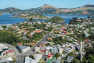
Port Chalmers is a town serving as the main port of the city of Dunedin, New Zealand. Port Chalmers lies ten kilometres inside Otago Harbour, some 15 kilometres northeast of Dunedin's city centre.

Toronto Harbour or Toronto Bay is a natural bay on the north shore of Lake Ontario, in Toronto, Ontario, Canada. Today, the harbour is used primarily for recreational boating, including personal vessels and pleasure boats providing scenic or party cruises. Ferries travel from docks on the mainland to the Islands, and cargo ships deliver aggregates and raw sugar to industries located in the harbour. Historically, the harbour has been used for military vessels, passenger traffic and cargo traffic. Waterfront uses include residential, recreational, cultural, commercial and industrial sites.

The Port of Boston is a major seaport located in Boston Harbor and adjacent to the City of Boston. It is the largest port in Massachusetts and one of the principal ports on the East Coast of the United States.
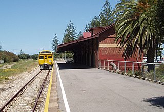
Outer Harbor railway station is the terminus station of the Outer Harbor line. Situated in the north-western Adelaide suburb of North Haven, it is 21.9 kilometres from Adelaide station.

The Port of San Francisco is a semi-independent organization that oversees the port facilities at San Francisco, California, United States. It is run by a five-member commission, appointed by the Mayor and approved by the Board of Supervisors. The Port is responsible for managing the larger waterfront area that extends from the anchorage of the Golden Gate Bridge, along the Marina district, all the way around the north and east shores of the city of San Francisco including Fisherman's Wharf and the Embarcadero, and southward to the city line just beyond Candlestick Point. In 1968, the State of California, via the California State Lands Commission for the State-operated San Francisco Port Authority, transferred its responsibilities for the Harbor of San Francisco waterfront to the City and County of San Francisco / San Francisco Harbor Commission through the Burton Act AB2649. All eligible State port authority employees had the option to become employees of the City and County of San Francisco to maintain consistent operation of the Port of San Francisco.

The Helen Delich Bentley Port of Baltimore is a shipping port along the tidal basins of the three branches of the Patapsco River in Baltimore, Maryland, on the upper northwest shore of the Chesapeake Bay. It is the nation's largest port facility for specialized cargo and passenger facilities. It is operated by the Maryland Port Administration (MPA), a unit of the Maryland Department of Transportation.

Victoria Harbour is a harbour, seaport, and seaplane airport in the Canadian city of Victoria, British Columbia. It serves as a cruise ship and ferry destination for tourists and visitors to the city and Vancouver Island. It is both a port of entry and an airport of entry for general aviation. Historically it was a shipbuilding and commercial fishing centre. While the Inner Harbour is fully within the City of Victoria, separating the city's downtown on its east side from the Victoria West neighbourhood, the Upper Harbour serves as the boundary between the City of Victoria and the district municipality of Esquimalt. The inner reaches are also bordered by the district of Saanich and the town of View Royal. Victoria is a federal "public harbour" as defined by Transport Canada. Several port facilities in the harbour are overseen and developed by the Greater Victoria Harbour Authority, however the harbour master's position is with Transport Canada.
Kingsport is a small seaside village located in Kings County, Nova Scotia, Canada, on the shores of the Minas Basin. It was famous at one time for building some of the largest wooden ships ever built in Canada.
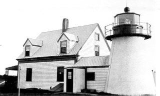
The Hyannis Rear Range Light, also known as the Hyannis Harbor Light, was a lighthouse and, for part of its life, one of a pair of range lights adjacent to Hyannis Harbor. The Range Rear tower was built in 1849 and equipped with a 5th order Fresnel lens in 1856. In 1863 the original birdcage lantern was replaced with a new cast iron one. In 1885, a front range light was added on the Old Colony Railroad Wharf, and the two lights together served to leading vessels to the wharf. The 20 foot Range Rear tower is shorter than most lighthouses, as its purpose was just to guide ships to the wharf. In the early 1800s, the railroad extended from its current terminus at the Hyannis Transportation Center, down what is now Old Colony Road to Harbor Road, where it ended in the 300 foot wharf that was a busy area for shipping coal, lumber, grain and fish.
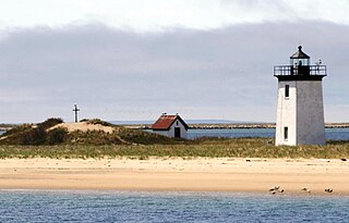
Long Point is a peninsula located in Provincetown, Massachusetts, at the extreme tip of Cape Cod, as it curls back in on itself to create Provincetown Harbor. The Long Point Light was built on this point in 1827. The lighthouse once shared this peninsula with a settlement of fishermen that came to be known as Long Point, Massachusetts. This Provincetown village grew and thrived from 1818 until the late 1850s. When the settlers decided to leave Long Point, they took most of their houses with them – about 30 structures in all – by floating them across the harbor.

Port Kembla is a man-made cargo port or artificial harbour, with an outer harbour protected by breakwaters and an inner harbour constructed by dredging, located in the Illawarra region of New South Wales, Australia.

Nanaimo Harbour, also known as the Port of Nanaimo, is a natural harbour on the east coast of Vancouver Island in the Canadian province of British Columbia. The city of Nanaimo runs along the west side of the harbour. Three islands, Newcastle, Protection, and Gabriola, along with Duke Point, form the eastern edge. The Port of Nanaimo includes the Inner Harbour, Nanaimo River estuary, Departure Bay, the waters on the east side of Newcastle and Protection Islands, and Northumberland Channel. The port is under the management of the Nanaimo Port Authority.
Germein Bay is a bay in the Australian state of South Australia located at the northern end Spencer Gulf on the gulf's east coast to the immediate north of the city of Port Pirie. Its extent includes the port known as ‘Port Pirie’ and the former port of Port Germein. Since 2012, the majority of the bay has been within the protected area known as the Upper Spencer Gulf Marine Park.


