East Harbor

Last updated
East Harbor
Provincetown before after railroad.png
The East Harbor in 1835 [1] and in 1887, [2] before it was renamed Pilgrim Lake
East Harbor
Click on the map for a fullscreen view
Location
Country United States
Location North Truro, Massachusetts
Coordinates 42°03′32″N70°07′46″W / 42.0589°N 70.1295°W / 42.0589; -70.1295
Details
Size720 acres (1.13 sq mi; 2.9 km2)

East Harbor is a tidal estuary in Truro, Massachusetts that was originally a harbor until it was cut off from Cape Cod Bay to form a salt marsh lagoon, later renamed Pilgrim Lake. It is now within the Cape Cod National Seashore.

Contents

Original Harbor

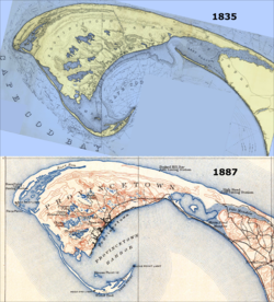
Until the latter half of the nineteenth century, the East Harbor was a natural embayment deep enough to shelter Provincetown's fishing fleet during the winter, and was connected to Cape Cod Bay through a 1,000-foot-wide (300 m) inlet. [3] This effectively isolated neighboring Provincetown from Truro and other towns on Cape Cod. [1]

Until late in the 19th century, there was not a single road leading in or out of Provincetown – the only way to travel by land to the rest of Cape Cod was to first head north, traversing a series of tall, rolling sand dunes, and to then follow the thin strip of beach along the northern shore line, known as the "backshore". [1] A wooden bridge was erected over the East Harbor in 1854, only to be destroyed by a winter storm and ice two years later. [4] Although the bridge was replaced the following year, a traveler using it still had to traverse several miles over a sand route, which, together with the backshore route, would occasionally be washed out by storms. [5] Prior to the railroad's arrival in 1873, Provincetown was like an island, in that it relied almost entirely upon the sea for its communication, travel, and commerce needs. [1] [5]

Back Barrier Lagoon – Pilgrim Lake

The harbor was artificially separated from Cape Cod Bay and cut off from tidal flow in 1868, when a dike was constructed across the inlet to facilitate the laying of track for the arrival of the railroad. The wooden bridge and sand road were finally replaced by a formal roadway in 1877. [6] [2] [3]

The exclusion of tides changed the harbor into a back barrier salt marsh lagoon. In the early 1900s, a real-estate developer named this lagoon "Pilgrim Lake", and the U.S. Geological Survey officially adopted that name in February 1910. [3]

But it also caused salinity to decline from natural levels of ~25-30 parts per thousand (ppt) to nearly freshwater by the time of the first documented fish survey in 1911. By this time the native estuarine fauna were largely extinguished. [7]

Over time, the blockage of tides had caused further ecological problems. The lack of tidal flushing deprived the system of salty, nutrient-poor, oxygen-rich Cape Cod Bay water and it became a stagnant freshwater pond. These conditions resulted in midge outbreaks, fish kills, and a proliferation of exotic species. [7]

After almost 140 years of impoundment, no native salt marsh vegetation was left in or around Pilgrim Lake. Instead, the floodplain was taken over by a non-native cattail species and some highly invasive plants like purple loosestrife (Lythrum salicaria) and common reed (Phragmites australis). [7]

Restoration

After an oxygen depletion and fish kill in 2001, the town of Truro and the National Park Service began to explore options to restore the estuary. They focused on a drainage pipe connecting Pilgrim Lake to Cape Cod Bay. This ~700-foot-long (210 m), 4 feet (1.2 m) diameter culvert had been fitted with clapper valves to allow freshwater to drain out of Pilgrim Lake, but prevented marine tides from flowing back into the system. [7]

To restore partial tidal exchange and to improve water quality, they opened the clapper valves, which have remained open continuously since November 2002. Despite limits on tidal exchange imposed by the pipe's small diameter, and the distance that it travels underground, they have observed a substantial response in the recovery of salinity and estuarine biota. [7]

In June 2008, Pilgrim Lake was officially renamed back to its original moniker, East Harbor. [3]

The 720-acre East Harbor system, includes Moon Meadow, Salt Meadow and the East Harbor lagoon. [7]

Related Research Articles

<span class="mw-page-title-main">Brackish water</span> Water with salinity between freshwater and seawater

Brackish water, sometimes termed brack water, is water occurring in a natural environment that has more salinity than freshwater, but not as much as seawater. It may result from mixing seawater and fresh water together, as in estuaries, or it may occur in brackish fossil aquifers. The word comes from the Middle Dutch root brak. Certain human activities can produce brackish water, in particular civil engineering projects such as dikes and the flooding of coastal marshland to produce brackish water pools for freshwater prawn farming. Brackish water is also the primary waste product of the salinity gradient power process. Because brackish water is hostile to the growth of most terrestrial plant species, without appropriate management it is damaging to the environment.

<span class="mw-page-title-main">Provincetown, Massachusetts</span> Town in Massachusetts, United States

Provincetown is a New England town located at the extreme tip of Cape Cod in Barnstable County, Massachusetts, in the United States. A small coastal resort town with a year-round population of 3,664 as of the 2020 United States Census, Provincetown has a summer population as high as 60,000. Often called "P-town" or "P'town", the locale is known for its beaches, harbor, artists, tourist industry, and as a popular vacation destination for the LGBT+ community.

<span class="mw-page-title-main">Estuary</span> Partially enclosed coastal body of brackish water

An estuary is a partially enclosed coastal body of brackish water with one or more rivers or streams flowing into it, and with a free connection to the open sea. Estuaries form a transition zone between river environments and maritime environments and are an example of an ecotone. Estuaries are subject both to marine influences such as tides, waves, and the influx of saline water, and to fluvial influences such as flows of freshwater and sediment. The mixing of seawater and freshwater provides high levels of nutrients both in the water column and in sediment, making estuaries among the most productive natural habitats in the world.

<span class="mw-page-title-main">Truro, Massachusetts</span> Town in Massachusetts, United States

Truro is a town in Barnstable County, Massachusetts, United States, comprising two villages: Truro and North Truro. Located slightly more than 100 miles (160 km) by road from Boston, it is a summer vacation community just south of the northern tip of Cape Cod, in an area known as the "Outer Cape". English colonists named it after Truro in Cornwall, United Kingdom.

<span class="mw-page-title-main">Marsh</span> Low-lying and seasonally waterlogged land

A marsh is — according to ecological definitions — a wetland that is dominated by herbaceous rather than woody plant species. More in general, the word can be used for any low-lying and seasonally waterlogged terrain. In Europe and in agricultural literature low-lying meadows that require draining and embanked polderlands are also referred to as marshes or marshland.

<span class="mw-page-title-main">Salt marsh</span> Coastal ecosystem between land and open saltwater that is regularly flooded

A salt marsh, saltmarsh or salting, also known as a coastal salt marsh or a tidal marsh, is a coastal ecosystem in the upper coastal intertidal zone between land and open saltwater or brackish water that is regularly flooded by the tides. It is dominated by dense stands of salt-tolerant plants such as herbs, grasses, or low shrubs. These plants are terrestrial in origin and are essential to the stability of the salt marsh in trapping and binding sediments. Salt marshes play a large role in the aquatic food web and the delivery of nutrients to coastal waters. They also support terrestrial animals and provide coastal protection.

<span class="mw-page-title-main">Narragansett Bay</span> Bay in the state of Rhode Island

Narragansett Bay is a bay and estuary on the north side of Rhode Island Sound covering 147 square miles (380 km2), 120.5 square miles (312 km2) of which is in Rhode Island. The bay forms New England's largest estuary, which functions as an expansive natural harbor and includes a small archipelago. Small parts of the bay extend into Massachusetts.

<span class="mw-page-title-main">Provincetown Harbor</span> Harbor in Provincetown, Massachusetts, USA

Provincetown Harbor is a large natural harbor located in the town of Provincetown, Massachusetts. The harbor is mostly 30 to 90 feet deep and stretches roughly 1 mile (1.6 km) from northwest to southeast and 2 miles (3.2 km) from northeast to southwest – one large, deep basin with no dredged channel necessary for boats to enter and exit.

<span class="mw-page-title-main">Mudflat</span> Coastal wetlands where sediments have been deposited by tides or rivers

Mudflats or mud flats, also known as tidal flats or, in Ireland, slob or slobs, are coastal wetlands that form in intertidal areas where sediments have been deposited by tides or rivers. A global analysis published in 2019 suggested that tidal flat ecosystems are as extensive globally as mangroves, covering at least 127,921 km2 (49,391 sq mi) of the Earth's surface. They are found in sheltered areas such as bays, bayous, lagoons, and estuaries; they are also seen in freshwater lakes and salty lakes alike, wherein many rivers and creeks end. Mudflats may be viewed geologically as exposed layers of bay mud, resulting from deposition of estuarine silts, clays and aquatic animal detritus. Most of the sediment within a mudflat is within the intertidal zone, and thus the flat is submerged and exposed approximately twice daily.

<span class="mw-page-title-main">Coos Bay</span> Estuary in Oregon, United States

Coos Bay is an estuary where the Coos River enters the Pacific Ocean, the estuary is approximately 12 miles long and up to two miles wide. It is the largest estuary completely within Oregon state lines. The Coos Bay watershed covers an area of about 600 square miles and is located in northern Coos County, Oregon, in the United States. The Coos River, which begins in the Oregon Coast Range, enters the bay from the east. From Coos River, the bay forms a sharp loop northward before arching back to the south and out to the Pacific Ocean. Haynes Inlet enters the top of this loop. South Slough branches off from the bay directly before its entrance into the Pacific Ocean. The bay was formed when sea levels rose over 20,000 years ago at the end of the Last Glacial Maximum, flooding the mouth of the Coos River. Coos Bay is Oregon's most important coastal industrial center and international shipping port, with close ties to San Francisco, the Columbia River, Puget Sound and other major ports of the Pacific rim.

<span class="mw-page-title-main">Ramsar site</span> Wetland site as designated by the Ramsar Convention

A Ramsar site is a wetland site designated to be of international importance under the Ramsar Convention, also known as "The Convention on Wetlands", an international environmental treaty signed on 2 February 1971 in Ramsar, Iran, under the auspices of UNESCO. It came into force on 21 December 1975, when it was ratified by a sufficient number of nations. It provides for national action and international cooperation regarding the conservation of wetlands, and wise sustainable use of their resources. Ramsar identifies wetlands of international importance, especially those providing waterfowl habitat.

<span class="mw-page-title-main">Cape Cod Bay</span> Large bay of the Atlantic Ocean adjacent to the U.S. state of Massachusetts

Cape Cod Bay is a large bay of the Atlantic Ocean adjacent to the U.S. state of Massachusetts. Measuring 604 square miles (1,560 km2) below a line drawn from Brant Rock in Marshfield to Race Point in Provincetown, Massachusetts, it is enclosed by Cape Cod to the south and east, and Plymouth County, Massachusetts, to the west. To the north of Cape Cod Bay lie Massachusetts Bay and the Atlantic Ocean. Cape Cod Bay is the southernmost extremity of the Gulf of Maine. Cape Cod Bay is one of the bays adjacent to Massachusetts that give it the name Bay State. The others are Narragansett Bay, Buzzards Bay, and Massachusetts Bay.

<span class="mw-page-title-main">North Truro, Massachusetts</span> Village in Cape Cod, Massachusetts

North Truro is a village in the town of Truro, Massachusetts, United States. Due to its proximity to urbanized Provincetown, it is somewhat more densely developed than the rest of the town, with houses and small resort facilities lining the two main thoroughfares, U.S. Route 6 and MA Route 6A. It is home to Truro Vineyards, one of two operating wineries on Cape Cod. North Truro is located at 42°03′35″N70°08′31″W.

<span class="mw-page-title-main">Tidal marsh</span> Marsh subject to tidal change in water

A tidal marsh is a marsh found along rivers, coasts and estuaries which floods and drains by the tidal movement of the adjacent estuary, sea or ocean. Tidal marshes experience many overlapping persistent cycles, including diurnal and semi-diurnal tides, day-night temperature fluctuations, spring-neap tides, seasonal vegetation growth and decay, upland runoff, decadal climate variations, and centennial to millennial trends in sea level and climate.

<span class="mw-page-title-main">Pamet River</span> River in Massachusetts, United States

The Pamet River is a 4.2-mile-long (6.8 km) river in Truro, Massachusetts on Cape Cod. It is named for the Paomet tribe.

<span class="mw-page-title-main">Seal Slough</span>

Seal Slough, also known as Marina Lagoon, is a narrow winding tidal channel through a tidal marsh in San Mateo and Foster City, California. This slough has been the object of a wetland restoration project in recent years to enhance habitat value. Dredging has been carried out in Seal Slough since at least 1954. When the original sewage treatment plant for the city of San Mateo was constructed in 1935, its discharge was directed to Seal Slough.

<span class="mw-page-title-main">Brackish marsh</span> Marsh with brackish level of salinity

Brackish marshes develop from salt marshes where a significant freshwater influx dilutes the seawater to brackish levels of salinity. This commonly happens upstream from salt marshes by estuaries of coastal rivers or near the mouths of coastal rivers with heavy freshwater discharges in the conditions of low tidal ranges.

Classification of wetlands has been a problematical task, with the commonly accepted definition of what constitutes a wetland being among the major difficulties. A number of national wetland classifications exist. In the 1970s, the Ramsar Convention on Wetlands of International Importance introduced a first attempt to establish an internationally acceptable wetland classification scheme.

<span class="mw-page-title-main">Long Point (Cape Cod)</span> Extreme tip of Cape Cod, Massachusetts and former human settlement

Long Point is a peninsula located in Provincetown, Massachusetts, at the extreme tip of Cape Cod, as it curls back in on itself to create Provincetown Harbor. The Long Point Light was built on this point in 1827. The lighthouse once shared this peninsula with a settlement of fishermen that came to be known as Long Point, Massachusetts. This Provincetown village grew and thrived from 1818 until the late 1850s. When the settlers decided to leave Long Point, they took most of their houses with them – about 30 structures in all – by floating them across the harbor.

Herring River is a river in Wellfleet, Massachusetts that includes a tidal estuary. As of 2014, there are plans and funding in place to restore the river, after the construction of a dike across the river in 1909 as a mosquito control project severely hampered the health of the estuary.

References

PD-icon.svg This article incorporates public domain material from websites or documents of the National Park Service .

  1. 1 2 3 4 A map of the extremity Of Cape Cod including the Townships of Provincetown & Truro: with a chart of their sea coast and of Cape Cod Harbour, State of Massachusetts (Map). 1 : 10,560. Cartography by U.S. Topographical Engineers, under direction of Maj. J.D. Graham; Reduced from orig. by Washington Hood. Bureau of U.S. Topographical Engineers. 1836. Retrieved 2 June 2012.
  2. 1 2 Massachusetts: Provincetown Sheet (Map). 1 : 62,500. Cartography by Henry Gannett (Chief Geographer) and Marcus Baker (Geographer-in-Charge). United States Geological Survey. July 1889 [Surveyed 1887]. Archived from the original (PDF) on 8 April 2013. Retrieved 23 May 2012.
  3. 1 2 3 4 "East Harbor gets its name back". Wicked Local Provincetown. 20 June 2008. Archived from the original on 21 June 2018. Retrieved 13 March 2014.
  4. Jennings, Herman A. (1890). Provincetown or Odds and Ends From the Tip End. Peaked Hill Press. p. 197.
  5. 1 2 Theriault, Wor. James J. "The Railroad Comes To Provincetown". King Hirams's Lodge of Ancient Free and Accepted Masons. Archived from the original on 4 April 2016. Retrieved 2 May 2012.
  6. Jennings (1890), p. 197.
  7. 1 2 3 4 5 6 "East Harbor Tidal Restoration Project". National Park Service. April 28, 2015. Retrieved 21 June 2018.