
Cape Cod is a peninsula extending into the Atlantic Ocean from the southeastern corner of Massachusetts, in the northeastern United States. Its historic, maritime character and ample beaches attract heavy tourism during the summer months. The name Cape Cod, coined in 1602 by Bartholomew Gosnold, is the ninth oldest English place-name in the U.S.

Barnstable County is a county located in the U.S. state of Massachusetts. At the 2020 census, the population was 228,996. Its county seat is Barnstable. The county consists of Cape Cod and associated islands.

Woods Hole is a census-designated place in the town of Falmouth in Barnstable County, Massachusetts, United States. It lies at the extreme southwestern corner of Cape Cod, near Martha's Vineyard and the Elizabeth Islands. The population was 781 at the 2010 census.

Bourne is a town in Barnstable County, Massachusetts, United States. The population was 20,452 at the 2020 census.
Falmouth is a town in Barnstable County, Massachusetts, United States. The population was 32,517 at the 2020 census, making Falmouth the second-largest municipality on Cape Cod after Barnstable. The terminal for the Steamship Authority ferries to Martha's Vineyard is located in the village of Woods Hole in Falmouth. Woods Hole also contains several scientific organizations such as the Woods Hole Oceanographic Institution (WHOI), the Marine Biological Laboratory (MBL), the Woodwell Climate Research Center, NOAA's Woods Hole Science Aquarium, and the scientific institutions' various museums.

The Strait of Georgia or the Georgia Strait is an arm of the Salish Sea between Vancouver Island and the extreme southwestern mainland coast of British Columbia, Canada, and the extreme northwestern mainland coast of Washington, United States. It is approximately 240 kilometres (150 mi) long and varies in width from 20 to 58 kilometres. Along with the Strait of Juan de Fuca and Puget Sound, it is a constituent part of the Salish Sea.

The Elizabeth Islands are a chain of over 20 small islands extending southwest from the southern coast of Cape Cod, Massachusetts in the United States.They are located at the outer edge of Buzzards Bay, north of Martha's Vineyard, from which they are separated by Vineyard Sound, and constitute the town of Gosnold in Dukes County, Massachusetts.
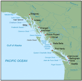
The Inside Passage is a coastal route for ships and boats along a network of passages which weave through the islands on the Pacific Northwest coast of the North American Fjordland. The route extends from southeastern Alaska in the United States, through western British Columbia in Canada, to northwestern Washington state in the United States. Ships using the route can avoid some of the bad weather in the open ocean and may visit some of the many isolated communities along the route. The Inside Passage is heavily travelled by cruise ships, freighters, tugs with tows, fishing craft, pleasure craft, and ships of the Alaska Marine Highway, BC Ferries, and Washington State Ferries systems. Coast Guard vessels of both Canada and the United States patrol and transit in the Passage.

The Cape Cod Railroad is a railroad in southeastern Massachusetts, running from Pilgrim Junction in Middleborough across the Cape Cod Canal Railroad Bridge, where it splits towards Hyannis in one direction and Falmouth in the other. It was incorporated in 1846 as the Cape Cod Branch Railroad to provide a rail link from the Fall River Railroad line in Middleborough to Cape Cod.

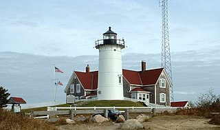
Nobska Light, originally called Nobsque Light, also known as Nobska Point Light is a lighthouse located near the division between Buzzards Bay, Nantucket Sound, and Vineyard Sound in the settlement of Woods Hole, Massachusetts on the southwestern tip of Cape Cod, Massachusetts. It overlooks Martha's Vineyard and Nonamesset Island. The light station was established in 1828, with the tower protruding above the keeper's house, and was replaced in 1876 by the current 42 foot tall iron tower. The light station was added to the National Register of Historic Places as Nobska Point Light Station in 1987.

Buzzards Bay is a bay of the Atlantic Ocean adjacent to the U.S. state of Massachusetts. It is approximately 28 miles long by 8 miles wide. It is a popular destination for fishing, boating, and tourism. Buzzards Bay is often considered the finest sailing location on the East Coast and is frequently compared in terms of sailing conditions to San Francisco Bay. Since 1914, Buzzards Bay has been connected to Cape Cod Bay by the Cape Cod Canal. In 1988, under the Clean Water Act, the Environmental Protection Agency and the Commonwealth of Massachusetts designated Buzzards Bay to the National Estuary Program, as "an estuary of national significance" that is threatened by pollution, land development, or overuse.
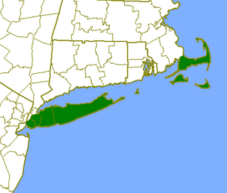
The Outer Lands is the prominent terminal moraine archipelagic region off the southern coast of New England in the United States. This eight-county region of Massachusetts, Rhode Island, and New York comprises the peninsula of Cape Cod and the islands of Nantucket, Martha's Vineyard, the Elizabeth Islands, Block Island, and Long Island, as well as surrounding islands and islets.
Canapitsit Channel is a channel that runs from Cuttyhunk Harbor to the Vineyard Sound and separates Nashawena Island from Cuttyhunk Island, two of the Elizabeth Islands off Cape Cod, Massachusetts. It is one of four straits allowing maritime passage between Buzzards Bay and the Vineyard Sound. The others are Quick's Hole, Robinson's Hole and Woods Hole. Canapitsit is an Indian word meaning "current passage".
Quick's Hole is the strait in Massachusetts' Elizabeth Islands separating Nashawena Island from Pasque Island. It is one of four straits allowing maritime passage between Buzzards Bay and the Vineyard Sound. The others are Canapitsit Channel, Robinson's Hole and Woods Hole.
Robinson's Hole is the strait in Massachusetts' Elizabeth Islands separating Naushon Island from Pasque Island. It is one of four straits allowing maritime passage between Buzzards Bay and the Vineyard Sound. The others are Canapitsit Channel, Quick's Hole and Woods Hole. Robinson's Hole is located in the town of Gosnold.

The Plymouth and Vineyard Sound Railroad was a railroad in Barnstable County, Massachusetts. It was incorporated in 1861 as the Vineyard Sound Railroad Company to provide a rail link between Sandwich and Woods Hole on the western part of Cape Cod, but the name was changed in 1868 before the railroad was completed. As part of the legislative enactment for the name change, the proposal was to extend the line north from Sandwich and connect with the Old Colony and Newport Railway terminus at Plymouth.

The CapeFlyer is a passenger rail service in Massachusetts between Boston and Cape Cod that began in 2013. It is operated by the Cape Cod Regional Transit Authority (CCRTA) in collaboration with the Massachusetts Bay Transportation Authority (MBTA) and the Massachusetts Department of Transportation (MassDOT). The service runs on the weekends, beginning Friday evenings and including holidays, between Memorial Day weekend and Labor Day weekend.

