
Boston Harbor is a natural harbor and estuary of Massachusetts Bay, and is located adjacent to the city of Boston, Massachusetts. It is home to the Port of Boston, a major shipping facility in the northeastern United States.

Cape Cod Bay is a large bay of the Atlantic Ocean adjacent to the U.S. state of Massachusetts. Measuring 604 square miles (1,560 km2) below a line drawn from Brant Rock in Marshfield to Race Point in Provincetown, Massachusetts, it is enclosed by Cape Cod to the south and east, and Plymouth County, Massachusetts, to the west. To the north of Cape Cod Bay lie Massachusetts Bay and the Atlantic Ocean. Cape Cod Bay is the southernmost extremity of the Gulf of Maine. Cape Cod Bay is one of the bays adjacent to Massachusetts that give it the name Bay State. The others are Narragansett Bay, Buzzards Bay, and Massachusetts Bay.
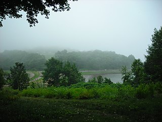
World's End is a 251-acre (1 km²) park and conservation area located on a peninsula in Hingham, Massachusetts. The peninsula is bordered by the Weir River to the North and East and Hingham Harbor to the West. The land is composed of four drumlins harboring tree groves interspersed with fields attractive to butterflies and grassland-nesting birds, and offers 4.5 miles of walking paths with views of the Boston skyline.
Ragged Island is an island in the Hingham Bay area of the Boston Harbor Islands National Recreation Area, in the U.S. state of Massachusetts. The island has a permanent size of 4 acres (16,000 m2), and it is composed of Roxbury puddingstone which rises to a height of 30 feet (9.1 m) above sea level. Broken ledges surround most of the island with small gravel beaches on the southeast and northwest sides; there are also small tidal mudflats.
The Hypocrite Channel is a small channel in Massachusetts Bay, located within the city limits of Boston. It's also located within the Boston Harbor Islands National Recreation Area. The channel runs between the islands of Half Tide Rocks, Calf Island, Little Calf Island, and Green Island.
The Graves is an aggregation of rock outcroppings in Massachusetts Bay, Massachusetts, United States. Situated some 11 miles (18 km) offshore of downtown Boston, it is the outermost island in the Boston Harbor Islands National Recreation Area. It is the location of The Graves Light, at 113 feet (34 m) tall the tallest lighthouse in Boston Harbor, and an important navigation aid for traffic to and from the port. The island has a permanent size of 1.8 acres, and rises to a height of 15 feet (4.6 m) above sea level; there is only aquatic vegetation on the island. The island is privately owned and the beacon and foghorn are managed by the Coast Guard, and is not open to the public.
Tewksbury Rock is a small, subsurface rock pinnacle located in Massachusetts Bay, within the city limits of Boston. The rock is northeast of Outer Brewster Island, west of Martin Ledge, south east of Green Island and far north of Boston Ledge. It is 15 feet (4.6 m) to 18 feet (5.5 m) below the surface of the water, but more than 45 feet (14 m) above the hard gravel floor of the bay.
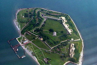
Georges Island is one of the islands in the Boston Harbor, situated just over 7 miles (11 km) from downtown Boston. The island has a permanent size of 39 acres (160,000 m2), plus an intertidal zone of a further 14 acres (57,000 m2), and rises to a height of 50 feet (15 m) above sea level. Historic Fort Warren is on the island. Because of this, and since a ferry operates from Boston to the island, it is a popular destination and one of the easiest islands to access in the Boston Harbor Islands National Recreation Area. George's Island is also home to the only Confederate memorial in Massachusetts, remembering 13 Confederate soldiers who died while imprisoned.

Houghs Neck is a one-square-mile (2.6 km2) peninsula in Quincy, Massachusetts. It is surrounded by Quincy Bay, Hingham Bay and Rock Island Cove. It is lined by Perry Beach, which runs along Manet Avenue; Nut Island, which is just beyond Great Hill at the very end of the peninsula; and Edgewater Drive.

Little Brewster Island is a rocky outer island in the Boston Harbor Islands National Recreation Area. It is best known as the location of Boston Light, one of only five remaining Coast Guard-manned lighthouses in the United States, and an important navigation aid for traffic to and from the Port of Boston. The island is situated some 9 miles (14 km) offshore of downtown Boston and has a permanent size of 3 acres (12,000 m2), plus an intertidal zone of a further 4 acres (16,000 m2).

Outer Brewster Island, also known as Outward Island, is one of the outer islands in the Boston Harbor Islands National Recreation Area and is situated some 10 miles offshore of downtown Boston. The island has a permanent size of 20 acres, and consists of exposed bedrock covered by fertile soil bounded by a rocky shore with steep cliffs. It provides a nesting habitat for coastal water birds, including cormorants, gulls, common eider ducks, glossy ibis and American oystercatchers. The birds are aggressive during their nesting season and access by humans, which is by private boat only, is discouraged during this period.

Spinnaker Island is an island in the Hingham Bay area of Boston Harbor in Massachusetts, USA. The island is part of the town of Hull, to which it is connected by a bridge, and is one of the few harbor islands that neither forms part of the Boston Harbor Islands National Recreation Area nor is considered within the municipal limits of the city of Boston.
Plymouth Harbor is a harbor located in Plymouth, a town in the South Shore region of the U.S. state of Massachusetts. It is part of the larger Plymouth Bay. Historically, Plymouth Harbor was the site of anchorage of the Mayflower where the Plymouth Colony pilgrims disembarked to establish a permanent settlement at Plymouth.

Plymouth Bay is a small, well-protected bay of the Atlantic Ocean on the western shore of larger Cape Cod Bay along the coastline of the Commonwealth of Massachusetts. Plymouth Bay retains historical significance for the landing at Plymouth Rock in 1620 by the Pilgrims aboard the Mayflower who proceeded to establish the first permanent Northern European settlement in North America at Plymouth Colony.

The Misery Islands are an 87-acre (350,000 m2) nature reserve established in 1935 in Salem Sound close to the Salem Harbor in Salem, Massachusetts. It is managed by the Trustees of Reservations. The islands are a part of the city of Salem, although they are much closer to the city of Beverly, in whose aquatic territory they lie.

Duxbury Bay is a bay on the coast of Massachusetts in the United States. The west shore of the bay is the town of Duxbury, Massachusetts; and the bay is formed by a sandbar called The Gurnet extending southeasterly from Marshfield, Massachusetts into Cape Cod Bay. The town of Marshfield was named for the estuarine wetland at the north end of the bay. The bay opens southerly toward Plymouth, Massachusetts between Captains Hill to the west and Saquish Head to the east.

Fort Andrews was created in 1897 as part of the Coast Defenses of Boston, Massachusetts. Construction began in 1898 and the fort was substantially complete by 1904. The fort was named after Major General George Leonard Andrews, an engineer and Civil War commander, who assisted in the construction of nearby Fort Warren in Boston Harbor. It occupies the entire northeast end of Peddocks Island in Boston Harbor, and was originally called the Peddocks Island Military Reservation. Once an active Coast Artillery post, it was manned by hundreds of soldiers and bristled with mortars and guns that controlled the southern approaches to Boston and Quincy Bay. The fort also served as a prisoner-of-war camp for Italian prisoners during World War II, who were employed as laborers following the Italian surrender to the Allies in 1943. Today, the fort is abandoned, and is managed by the Massachusetts Department of Conservation and Recreation, as part of the Boston Harbor Islands National Recreation Area.
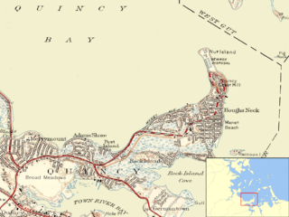
Nut Island is a former island in Boston Harbor, part of the Boston Harbor Islands National Recreation Area. The island has been connected through a short causeway to the end of Houghs Neck, becoming part of the mainland of Quincy, Massachusetts.

Weir River is a short stream and estuary that empties into Hingham Bay, part of Boston Harbor in Massachusetts, United States. The name is attributed to the location of a fishing weir in the stream. The river gives its name to a larger watershed and Weir River Farm, a park and nature reserve owned by The Trustees of Reservations.
This is a list of rotaries in the state of Massachusetts in the United States. Intersections that are called traffic circles or roundabouts in the rest of the US are referred to as "rotaries" in Massachusetts, as well as other parts of New England including parts of Connecticut, New Hampshire & Vermont.


