Pawtucket Canal

Last updated
Pawtucket Canal in context 1975 map of canal system in Lowell, Massachusetts.png
Pawtucket Canal in context
Pawtucket Canal Pawtucket Canal, Lowell MA.jpg
Pawtucket Canal

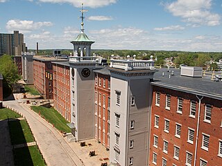
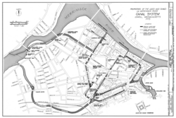
Completed in 1796, the Pawtucket Canal was originally built as a transportation canal to circumvent the Pawtucket Falls of the Merrimack River in East Chelmsford, Massachusetts. In the early 1820s it became a major component of the Lowell power canal system. with the founding of the textile industry at what became Lowell. [1]

Pawtucket Falls (Massachusetts) waterfall on the Merrimack River at Lowell, Massachusetts

Pawtucket Falls is a waterfall on the Merrimack River at Lowell, Massachusetts. The waterfall and rapids below it drop a total of 32 feet in a little under a mile, and was an important fishing ground for the Pennacook Indians in pre-colonial times.

Merrimack River river in New Hampshire and Massachusetts, United States

The Merrimack River is a 117-mile-long (188 km) river in the northeastern United States. It rises at the confluence of the Pemigewasset and Winnipesaukee rivers in Franklin, New Hampshire, flows southward into Massachusetts, and then flows northeast until it empties into the Gulf of Maine at Newburyport. From Pawtucket Falls in Lowell, Massachusetts, onward, the Massachusetts–New Hampshire border is roughly calculated as the line three miles north of the river.

Chelmsford, Massachusetts Town in Massachusetts, United States

Chelmsford is a town in Middlesex County, Massachusetts in the United States. As of the 2010 United States Census, the town's population was 33,802. Only 48.4% are male and the median age of residents in Chelmsford is 39.2 years old. It is located 24 miles (39 km) northwest of Boston and, bordering on the city of Lowell, is part of the Greater Lowell metropolitan area. Besides Lowell on its northeast, Chelmsford is surrounded by four towns: Tyngsborough to the north, Billerica to the southeast, Carlisle to the south, and Westford to the west. Chelmsford is bordered by two sizable rivers: the Merrimack River to the north, and the Concord River to the east.

Contents

The Pawtucket Falls are a mile long series of falls and rapids over which the Merrimack River drops 32 feet. The falls hampered the shipment of inland goods, mostly lumber, to the mouth of the Merrimack and Newburyport, Massachusetts. Newburyport was then one of the largest shipbuilding centers in New England, and a steady supply of wood from New Hampshire was critical to its industry.

Lumber wood that has been processed into beams and planks

Lumber or timber is a type of wood that has been processed into beams and planks, a stage in the process of wood production. Lumber is mainly used for structural purposes but has many other uses as well.

Newburyport, Massachusetts City in Massachusetts, United States

Newburyport is a small coastal, scenic, and historic city in Essex County, Massachusetts, United States, 35 miles (56 km) northeast of Boston. The population was 17,416 at the 2010 census. A historic seaport with a vibrant tourism industry, Newburyport includes part of Plum Island. The mooring, winter storage and maintenance of recreational boats, motor and sail, still contribute a large part of the city's income. A Coast Guard station oversees boating activity, especially in the sometimes dangerous tidal currents of the Merrimack River.

Shipbuilding construction of ships and floating vessels

Shipbuilding is the construction of ships and other floating vessels. It normally takes place in a specialized facility known as a shipyard. Shipbuilders, also called shipwrights, follow a specialized occupation that traces its roots to before recorded history.

The original canal was built by wealthy Boston merchants who formed a limited liability corporation called the Proprietors of Locks and Canals, one of the first of its kind in the United States. However, within a decade of its construction the Middlesex Canal was completed, connecting the Merrimack directly with Boston, Massachusetts. Bringing goods directly to Boston was more advantageous for merchants, and the Pawtucket Canal fell out of favor for inland transport.

Limited liability Business structure where shareholders cannot owe more than their stake in a venture

Limited liability is where a person's financial liability is limited to a fixed sum, most commonly the value of a person's investment in a company or partnership. If a company with limited liability is sued, then the claimants are suing the company, not its owners or investors. A shareholder in a limited company is not personally liable for any of the debts of the company, other than for the amount already invested in the company and for any unpaid amount on the shares in the company, if any. The same is true for the members of a limited liability partnership and the limited partners in a limited partnership. By contrast, sole proprietors and partners in general partnerships are each liable for all the debts of the business.

The Proprietors of Locks and Canals on the Merrimack River is a limited liability corporation founded on June 27, 1792, making it one of the oldest corporations in the United States. Its named incorporators were Dudley Atkins Tyng, William Coombs, Joseph Tyler, Nicholas Johnson, and Joshua Carter.

United States Federal republic in North America

The United States of America (USA), commonly known as the United States or America, is a country comprising 50 states, a federal district, five major self-governing territories, and various possessions. At 3.8 million square miles, the United States is the world's third or fourth largest country by total area and is slightly smaller than the entire continent of Europe's 3.9 million square miles. With a population of over 327 million people, the U.S. is the third most populous country. The capital is Washington, D.C., and the largest city by population is New York City. Forty-eight states and the capital's federal district are contiguous in North America between Canada and Mexico. The State of Alaska is in the northwest corner of North America, bordered by Canada to the east and across the Bering Strait from Russia to the west. The State of Hawaii is an archipelago in the mid-Pacific Ocean. The U.S. territories are scattered about the Pacific Ocean and the Caribbean Sea, stretching across nine official time zones. The extremely diverse geography, climate, and wildlife of the United States make it one of the world's 17 megadiverse countries.

The investors in the Boston Manufacturing Company having successfully built upon Francis Cabot Lowell and Paul Moody's work in building a successfully integrated cotton mill at Waltham, Massachusetts on the Charles River were looking for a site that offered more waterpower and the Pawtucket Falls offered what they needed. In 1821 they bought the Proprietors of Locks and Canals and with it the water rights of the Merrimack River upstream from the Pawtucket Falls. The Pawtucket Canal was deepened to become a power canal, and the first of 5.6 miles of canals in the soon to be named City of Lowell, Massachusetts. The first canal built off the Pawtucket Canal was the Merrimack Canal, which powered the Merrimack Manufacturing Company, thus starting the Lowell experiment, and the first planned industrial city in the United States.

Paul Moody (inventor) American inventor

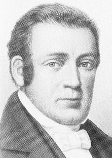
Paul Moody was a U.S. textile machinery inventor born in Byfield, Massachusetts. He is often credited with developing and perfecting the first power loom in America, which launched the first successful integrated cotton mill at Waltham, Massachusetts in 1814, under the leadership of Francis Cabot Lowell and his associates.

Waltham, Massachusetts City in Massachusetts, United States

Waltham is a city in Middlesex County, Massachusetts, United States, and was an early center for the labor movement as well as a major contributor to the American Industrial Revolution. The original home of the Boston Manufacturing Company, the city was a prototype for 19th century industrial city planning, spawning what became known as the Waltham-Lowell system of labor and production. The city is now a center for research and higher education, home to Brandeis University and Bentley University. The population was 60,636 at the census in 2010.

Charles River river in Massachusetts, United States

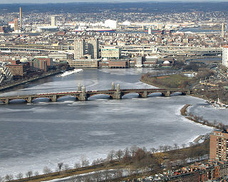
The Charles River is an 80-mile-long (129 km) long river in eastern Massachusetts. From its source in Hopkinton the river flows in a northeasterly direction, traveling through 23 cities and towns before reaching the Atlantic Ocean at Boston. The Native-American name for the Charles River was Quinobequin, meaning "meandering".

The canal is operated today by Boott Hydro, LLC.

See also

Related Research Articles

Lowell, Massachusetts City in Massachusetts, United States

Lowell is a city in the U.S. Commonwealth of Massachusetts. Located in Middlesex County, Lowell was a county seat until Massachusetts disbanded county government in 1999. With an estimated population of 109,945 in 2014, it is the fourth-largest city in Massachusetts, and the second-largest in the Boston metropolitan statistical area. The city is also part of a smaller Massachusetts statistical area called Greater Lowell, as well as New England's Merrimack Valley region.

Lowell National Historical Park A National Historical Park of the United States located in Lowell, Massachusetts

Lowell National Historical Park is a National Historical Park of the United States located in Lowell, Massachusetts. Established in 1978 a few years after Lowell Heritage State Park, it is operated by the National Park Service and comprises a group of different sites in and around the city of Lowell related to the era of textile manufacturing in the city during the Industrial Revolution. In 2019, the park is scheduled to be included as Massachusetts' representative in the America the Beautiful Quarters series.

Francis Cabot Lowell Wikimedia disambiguation page

Francis Cabot Lowell was an American businessman for whom the city of Lowell, Massachusetts, is named. He was instrumental in bringing the Industrial Revolution to the United States.

Middlesex Canal canal in Massachusetts, United States of America

The Middlesex Canal was a 27-mile (44-kilometer) barge canal connecting the Merrimack River with the port of Boston. When operational it was 30 feet wide, and 3 feet deep, with 20 locks, each 80 feet long and between 10 and 11 feet wide. It also had 8 aqueducts.

Boston and Lowell Railroad transport company

The Boston and Lowell Railroad was a railroad that operated in Massachusetts in the United States. It was one of the first railroads in North America and the first major one in the state. The line later operated as part of the Boston and Maine Railroad's Southern Division.

Mine Falls Park park in Nashua

Mine Falls Park is a 325-acre (132 ha) park in the city of Nashua, New Hampshire. Located in the heart of the city, it was purchased in 1969 from the Nashua, New Hampshire Foundation with city and federal Land and Water Conservation Fund (LWCF) money. It is bordered on the north by the Nashua River and on the south by the millpond and power canal system.

Patrick Tracy Jackson American manufacturer

Patrick Tracy Jackson was a United States manufacturer, one of the founders of the Boston Manufacturing Company of Waltham, Massachusetts, and later a founder of the Merrimack Manufacturing Company, whose developments formed the nucleus of Lowell, Massachusetts.

Turners Falls Canal canal in Massachusetts, United States of America

The Turners Falls Canal, also historically known as the Montague Canal, was a canal along the Connecticut River in Montague, Massachusetts. It was reconstructed in 1869.

Merrimack Canal canal in Massachusetts, United States of America

The Merrimack Canal is a power canal in Lowell, Massachusetts. The canal, dug in the 1820s, begins at the Pawtucket Canal just above Swamp Locks, and empties into the Merrimack River near the Boott Cotton Mills. The Merrimack Canal was the first major canal to be dug at Lowell exclusively for power purposes, and delivered 32 feet (9.8 m) of hydraulic head to the mills of the Merrimack Manufacturing Company. The Merrimack Manufacturing Company was the first of the major textile mills constructed in Lowell. It was demolished around 1960.

The history of Lowell, Massachusetts is closely tied to the city's location along the Pawtucket Falls of the Merrimack River, from being an important fishing ground for the Pennacook tribe to providing water power for the factories that formed the basis of the city's economy for a century. The city of Lowell was started in the 1820s as a money-making venture and social project referred to as "The Lowell Experiment", and quickly became the United States' largest textile center. However, within approximately a century, the decline and collapse of that industry in New England placed the city into a deep recession. Lowell's "rebirth", partially tied to Lowell National Historical Park, has made it a model for other former industrial towns, although the city continues to struggle with deindustrialization and suburbanization.

Kirk Boott United States industrialist

Kirk Boott was an American Industrialist instrumental in the early history of Lowell, Massachusetts.

Blackstone River and Canal Heritage State Park

The Blackstone River and Canal Heritage State Park is a part of the state park system of the Commonwealth of Massachusetts, managed by the Massachusetts Department of Conservation and Recreation (DCR). This 1,000-acre (4.0 km2) park "recalls the role of canals in transporting raw materials and manufactured goods between emerging industrial centers." The Blackstone River and Canal Heritage State Park at Uxbridge, Massachusetts, is the midpoint of the Blackstone River Valley National Heritage Corridor of the National Park System. The Blackstone River and Valley is where the industrial revolution was born in America. The southern entrance to this state park is the site of the historic Stanley Woolen Mill, currently being redeveloped for commercial and tourism. The Native American Nipmuc name for the village here was "Wacentug", translated as "bend in the river".

Lowell Power Canal System and Pawtucket Gatehouse canal in Massachusetts, United States of America

The Lowell Power Canal System is the largest power canal system in the United States, at 5.6 miles in length. The system's estimated output is 10,000 horsepower, operating six major canals on two levels, controlled by numerous gates. The system was begun in the 1790s, beginning its life as a transportation canal called the Pawtucket Canal, which was constructed to get logs from New Hampshire down the Merrimack River to shipbuilding centers at Newburyport, Massachusetts, bypassing the 30-plus-foot drop of the Pawtucket Falls.

Boott Mills

The Boott Mills in Lowell, Massachusetts were a part of an extensive group of cotton mills, built in 1835 alongside a power canal system in this important cotton town. Their founder was Kirk Boott, one of the early mill leaders in Lowell. Today, the Boott Mills complex is the most intact in Lowell and is part of Lowell National Historical Park. It houses the Boott Cotton Mills Museum.

Merrimack Manufacturing Company The first of the major textile manufacturing concerns to open in Lowell, Massachusetts, beginning operations in 1823

The Merrimack Manufacturing Company was the first of the major textile manufacturing concerns to open in Lowell, Massachusetts, beginning operations in 1823.

Merrimack Valley region in Massachusetts and New Hampshire

The Merrimack Valley is a bi-state region along the Merrimack River in the U.S. states of New Hampshire and Massachusetts. The Merrimack is one of the larger waterways in the New England region and has helped define the livelihood and culture of those living along it since native times.

Saco-Lowell Shops

The Saco-Lowell Shops was once one of the largest textile machine manufacturers in the United States. It was formed in 1912 with a merger between the Lowell Machine Shop with the Saco-Pettee Machine Company. At its peak in the 1920s, the company had manufacturing facilities in Lowell and Newton, Massachusetts, and Biddeford, Maine. The company maintained their executive office at 77 Franklin Street in Boston, and also had a southern office in Charlotte, North Carolina.

References

Coordinates: 42°38′39″N71°18′21″W / 42.64417°N 71.30583°W / 42.64417; -71.30583

Geographic coordinate system Coordinate system

A geographic coordinate system is a coordinate system that enables every location on Earth to be specified by a set of numbers, letters or symbols. The coordinates are often chosen such that one of the numbers represents a vertical position and two or three of the numbers represent a horizontal position; alternatively, a geographic position may be expressed in a combined three-dimensional Cartesian vector. A common choice of coordinates is latitude, longitude and elevation. To specify a location on a plane requires a map projection.