Lawrence is a city located in Essex County, Massachusetts, United States, on the Merrimack River. At the 2020 census, the city had a population of 89,143. Surrounding communities include Methuen to the north, Andover to the southwest, and North Andover to the east. Lawrence and Salem were the county seats of Essex County, until the state abolished county government in 1999. Lawrence is part of the Merrimack Valley.

Methuen is a 23-square-mile city in Essex County, Massachusetts, United States. The population was 53,059 at the 2020 census. Methuen lies along the northwestern edge of Essex County, just east of Middlesex County and just south of Rockingham County, New Hampshire. The city is bordered by Haverhill to the northeast, North Andover to the southeast, Lawrence and Andover to the south, Dracut to the west, Pelham, New Hampshire to the northwest, and Salem, New Hampshire to the north. Methuen is located 17 miles (27 km) southwest from Newburyport, 30 miles (48 km) north-northwest of Boston and 25 miles (40 km) south-southeast of Manchester, New Hampshire.

The Middlesex Canal was a 27-mile (44-kilometer) barge canal connecting the Merrimack River with the port of Boston. When operational it was 30 feet wide, and 3 feet deep, with 20 locks, each 80 feet long and between 10 and 11 feet wide. It also had eight aqueducts.

The Spicket River is a 17.7-mile-long (28.5 km) river located in New Hampshire and Massachusetts in the United States. It is a left tributary of the Merrimack River, part of the Gulf of Maine watershed. It is sometimes spelled "Spickett".

The Moseley Wrought Iron Arch Bridge, also known as the Upper Pacific Mills Bridge, is a historic, riveted, wrought iron bowstring arch bridge now located on the campus of Merrimack College in North Andover, Massachusetts. It was added to the National Historic Civil Engineering Landmark list in 1998 and was originally part of the North Canal Historic District on the National Register of Historic Place. It is the oldest iron bridge in Massachusetts, and one of the oldest iron bridges in the United States. It was the first bridge in the United States to use riveted wrought iron plates for the triangular-shaped top chord.

Wheelockville is a village in the town (township) of Uxbridge, Massachusetts, United States. Part of the village centering on Mendon and Henry streets is listed on the National Register of Historic Places as the Wheelockville Historic District. Wheelockville appears on the Blackstone U.S. Geological Survey Map. The Village receives municipal services from Uxbridge, for fire, police, EMS, School district, public works, and other services. Worcester's Judicial District includes Uxbridge District Court. The geography of Wheelockville includes several other distinct mill villages, including: Hecla and Elmdale.

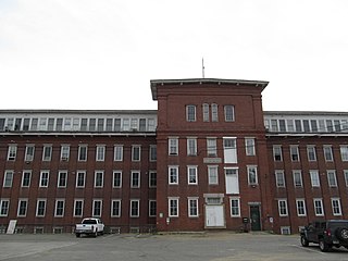
The Arlington Mills Historic District encompasses a major 19th century textile manufacturing complex in Lawrence and Methuen, Massachusetts. Developed between 1865 and 1925, it was one of the state's largest textile operations at its height. At the time of its listing on the National Register of Historic Places in 1985, the mill complex was owned by Malden Mills.

Essex Company Machine Shop, also known as Stone Mill or the Lawrence Machine Shop, is a historic machine shop on Union Street in Lawrence, Massachusetts. It was built in 1846 and added to the National Register of Historic Places in 1972.

The Great Stone Dam was built between 1845 and 1848 on the site of Bodwell's Falls on the Merrimack River in what became Lawrence, Massachusetts. The dam has a length of 900 feet (270 m) and a height of 35 feet (11 m).

13 Annis Street is a historic mill worker house in Methuen, Massachusetts. Built about 1880, it is a typical small residence built for workers at the nearby Arlington Mills. It was added to the National Register of Historic Places in 1984, but has lost many of its exterior decorative details since.
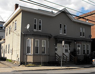
113–115 Center Street is a historic two-family house in the Arlington Mills district of southern Methuen, Massachusetts. Built about 1880, it is a rare surviving example of the type of worker housing built early in the expansion of the Arlington Mills. It was added to the National Register of Historic Places in 1984.

The Pleasant–High Historic District encompasses the earliest area of non-agricultural residential development in Methuen, Massachusetts. It encompasses houses along High and Pleasant Streets from just east of Broadway to Vine Street, as well as a few that face on adjoining streets. The district was listed on the National Register of Historic Places in 1984; on its western boundary it abuts the Spicket Falls Historic District.

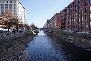
The Spicket Falls Historic District encompasses the historic industrial and commercial heart of Methuen, Massachusetts, and one of the lower Merrimack River's best-preserved 19th century mill complexes. It is centered on the falls of the Spicket River, from which the 19th century textile mills of Methuen derived their power. The historic district, listed on the National Register of Historic Places in 1984, includes commercial and civic buildings in and near Gaunt Square, the heart of the city, and along both sides of the Spicket River between Gaunt Square and the Boston and Maine Railroad tracks south of the river. It abuts the residential Pleasant-High Historic District, which lies to its east.

The Hamilton Woolen Company Historic District encompasses the well preserved "Big Mill" complex of the Hamilton Woolen Company, built in the mid 19th century. Located at the confluence of McKinstry Brook and the Quinebaug River in central Southbridge, Massachusetts, the complex consists of a cluster of mill buildings and a rare collection of 1830s brick mill worker housing units located nearby. The district was listed on the National Register of Historic Places in 1989.

The Merrimack Valley is a bi-state region along the Merrimack River in the U.S. states of New Hampshire and Massachusetts. The Merrimack is one of the larger waterways in New England and has helped to define the livelihood and culture of those living along it for millennia.

The Winooski Falls Mill District is located along the Winooski River in the cities of Winooski and Burlington, Vermont, in the United States of America. It encompasses a major industrial area that developed around two sets of falls on the river in the 19th century.

The Wood Worsted Mill is located at South Union St. and Merrimack Street, on the south bank of the Merrimack River, in Lawrence, Massachusetts. The mill building was constructed between 1906 and 1909 for the American Woolen Company, and was dubbed by some locals as the "eighth wonder of the world" due to its size. It is a six-story brick building that is 1,300 feet (400 m) long and 125 feet (38 m) high, and encompasses some 17 miles (27 km) of aisles. Its purpose when built was to perform the complete textile manufacturing cycle of worsted woolens, from raw material to finished fabric, under a single roof.

The Nashua Manufacturing Company Historic District in Nashua, New Hampshire, is a historic district that was listed on the National Register of Historic Places (NRHP) in 1987. It encompasses an area just west of downtown Nashua, roughly located along the southern bank of the Nashua River, bordered on the west side by Mine Falls Park, on the south side by the Nashua River canal, up to Ledge Street, and from the east side by Factory, Pine and Water streets, up to the Main Street bridge.

The Cocheco Mills comprise a historic mill complex in the heart of Dover, New Hampshire. The mills occupy a bend in the Cochecho River that has been site of cotton textile manufacturing since at least 1823, when the Dover Manufacturing Company supplanted earlier sawmills and gristmills. The present mill buildings were built between the 1880s and the early 20th century, and were listed on the National Register of Historic Places in 2014.
The Salmon Falls Mill Historic District encompasses a historic mill complex on Front Street in Rollinsford, New Hampshire. The complex includes four major structures and seven smaller ones, on about 14 acres (5.7 ha) of land along the Salmon Falls River. They were built between about 1840 and the mid-1860s, and have an unusual architectural unity, for additions made to the buildings were done with attention to matching design elements from the existing structures. The Number 2 Mill, built in 1848, was an early location where a turbine was used instead of a waterwheel to provide power to the mill machinery. The district was listed on the National Register of Historic Places in 1980.


