
The Quabbin Reservoir is the largest inland body of water in Massachusetts, United States, and was built between 1930 and 1939. Along with the Wachusett Reservoir, it is the primary water supply for Boston, 65 miles (105 km) to the east, and 40 other cities and towns in Greater Boston. The Quabbin also supplies water to three towns west of the reservoir and acts as backup supply for three others. By 1989, it supplied water for 2.5 million people, about 40% of the state's population at the time. It has an aggregate capacity of 412 billion US gallons (1,560 GL) and an area of 38.6 square miles (99.9 km2).

The Massachusetts Water Resources Authority (MWRA) is a public authority in the Commonwealth of Massachusetts that provides wholesale drinking water and sewage services to 3.1 million people in sixty-one municipalities and more than 5,500 large industrial users in the eastern and central parts of the state, primarily in the Boston area.

The Southern Nevada Water Authority (SNWA) is a government agency that was founded in 1991 to manage Southern Nevada's water needs on a regional basis in Clark County.

Fresh Pond is a reservoir and park in Cambridge, Massachusetts. Prior to the Pond's use exclusively as a reservoir, its ice had been harvested by Boston's "Ice King", Frederic Tudor, and others, for shipment to North American cities and to tropical areas around the world. Fresh Pond is bordered by Fresh Pond Parkway, Huron Avenue, Grove Street, Blanchard Road, and Concord Avenue.
Water supply and sanitation in Singapore are intricately linked to the historical development of Singapore. It is characterised by a number of outstanding achievements in a challenging environment with geographical limitations. Access to water in Singapore is universal, affordable, efficient and of high quality.

A combination of aqueducts, reservoirs, and tunnels supplies fresh water to New York City. With three major water systems stretching up to 125 miles (201 km) away from the city, its water supply system is one of the most extensive municipal water systems in the world.

The Metropolitan Water Reclamation District of Greater Chicago (MWRD), originally known as the Sanitary District of Chicago, is a special-purpose district chartered to operate in Cook County, Illinois since 1889. Although its name may imply otherwise, it is not a part of the City of Chicago's local government but is created by Illinois state government with an elected Board of Commissioners. The MWRD's main purposes are the reclamation and treatment of wastewater and flood water abatement in Cook County to protect the health and safety of citizens and of area waterways. In 1900, the District notably reversed the flow of the Chicago River, and it is currently involved in the large multi-decade construction of the "Deep Tunnel," Tunnel and Reservoir Plan (TARP).
The Quinapoxet River is part of the Nashua River watershed in northern Massachusetts in the United States. It is part of the Massachusetts Water Resources Authority water system supplying drinking water to the greater Boston area.
Dallas Water Utilities (DWU) is the water and wastewater service operated by the City of Dallas, Texas, in the United States. DWU is a non-profit City of Dallas department that provides services to the city and 31 nearby communities, employs approximately 1450 people, and consists of 26 programs. DWU's budget is completely funded through the rates charged for water and wastewater services provided to customers. Rates are based on the cost of providing the services. The department does not receive any tax revenues. Primary authority and rules for the department are listed in Chapter 49Archived 2006-10-04 at the Wayback Machine of the Dallas City Code.

The Croton Distributing Reservoir, also known as the Murray Hill Reservoir, was an above-ground reservoir at 42nd Street and Fifth Avenue in the New York City borough of Manhattan. Covering 4-acre (16,000 m2) and holding 20 million US gallons (76,000 m3), it supplied the city with drinking water during the 19th century. Its massive 50-foot-high (15 m) granite walls, which presented a vaguely Egyptian-style facade, were 25 feet (7.6 m) thick. Atop the walls was a public promenade offering panoramic views; Edgar Allan Poe enjoyed walking there.

The New York City Department of Environmental Protection (DEP) is the department of the government of New York City that manages the city's water supply and works to reduce air, noise, and hazardous materials pollution.
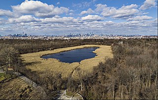
Ridgewood Reservoir is a decommissioned 19th century reservoir and freshwater wetland on the border between the New York City boroughs of Brooklyn and Queens, within what is now Highland Park. Although the reservoir was originally built to secure a reliable water supply for the City of Brooklyn, it is positioned on the Queens side of the border in the neighborhood of Glendale. The reservoir and park are bounded on the north by the Jackie Robinson Parkway, on the south by Highland Boulevard, on the west by Vermont Place and on the east by Cypress Hills National Cemetery.
The Erie Water Works was incorporated in 1865 as the Erie Water and Gas Company to provide drinking water and fire hydrant water for the city of Erie, Pennsylvania. The Water Works, also known as the Erie City Water Authority, replaced the Erie Water Systems. Its board of commissioners operates independently of the city government.

East Mountain is a traprock mountain ridge located in the Connecticut River Valley of Massachusetts. It is part of the narrow, linear Metacomet Ridge that extends from Long Island Sound near New Haven, Connecticut, north through the Connecticut River Valley of Massachusetts to the Vermont border. East Mountain is known for its extensive scenic cliffs, unique microclimate ecosystems, and rare plant communities. It is traversed by the 110-mile (180 km) Metacomet-Monadnock Trail.

Silas Wright Titus was an engineer who discovered and patented deep water pumping technology and discovered early water supplies for New York City and other towns and cities in the United States in the late nineteenth century. He was known as “The Water Wizard”.
The Portland Water Bureau is the municipal water department for the city of Portland in the U.S. state of Oregon. The bureau manages a water supply that comes mainly from the Bull Run River in the foothills of the Cascade Range east of the city and secondarily from the Columbia South Shore Well Field near the Columbia River. As of 2023, Mingus Mapps was the city commissioner in charge of the bureau, and the chief administrator is Michael Stuhr. Budgeted departmental revenues for fiscal year 2015–16 included about $157 million for charges for services.

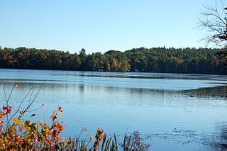
Stony Brook is a stream largely running through Lincoln and Weston, Massachusetts, then forming the Weston/Waltham boundary, and emptying into the Charles River across from the Waltham/Newton boundary. It has two tributaries, Cherry Brook and Hobbs Brook, and its watershed includes about half of Lincoln and Weston as well as parts of Lexington and Waltham. Since 1887, it has been the water supply for Cambridge, along with the Hobbs Brook Reservoir.

The Holyoke Water Works (HWW), sometimes referred to as the Holyoke Reservoir System, is a public drinking water utility and municipal service agency of the City of Holyoke, Massachusetts, which provides clean drinking water to that city. Founded in 1872 by an act of Massachusetts General Court, the system was developed as a series of reservoirs to serve the growing city's residents and industry at the end of the 19th century. Today its two primary drinking water sources are the Tighe-Carmody Reservoir in Southampton, Massachusetts and McLean Reservoir in Holyoke. While it maintains reserve drinking water supplies at the Ashley and the Whiting Street Reservoirs.

This page is about the Croton River watershed, a hydrological feature. For the component of the New York City water supply system with a similar name, see Croton Watershed

Whiting Street Reservoir, often shortened as Whiting Reservoir a Class I hazard reservoir, is an auxiliary drinking supply for the city of Holyoke, Massachusetts. The reservoir has an impound capacity of more than 479 million gallons of water and a safe yield of 1.5 million US gallons (5,700 m3) of water per day.


