
Canals or artificial waterways are waterways or engineered channels built for drainage management or for conveyancing water transport vehicles. They carry free, calm surface flow under atmospheric pressure, and can be thought of as artificial rivers.

Mount Holyoke, a traprock mountain, elevation 935 feet (285 m), is the westernmost peak of the Holyoke Range and part of the 100-mile (160 km) Metacomet Ridge. The mountain is located in the Connecticut River Valley of western Massachusetts, and is the namesake of nearby Mount Holyoke College. The mountain is located in the towns of Hadley and South Hadley, Massachusetts. It is known for its historic summit house, auto road, scenic vistas, and biodiversity. The mountain is crossed by the 110-mile (180 km) Metacomet-Monadnock Trail and numerous shorter trails. Mount Holyoke is the home of J.A. Skinner State Park which is accessible from Route 47 in Hadley, Massachusetts.

The Chesapeake and Ohio Canal, abbreviated as the C&O Canal and occasionally called the Grand Old Ditch, operated from 1831 until 1924 along the Potomac River between Washington, D.C. and Cumberland, Maryland. It replaced the Potomac Canal, which shut down completely in 1828, and could operate during months in which the water level was too low for the former canal. The canal's principal cargo was coal from the Allegheny Mountains.

The Connecticut River is the longest river in the New England region of the United States, flowing roughly southward for 406 miles (653 km) through four states. It rises 300 yards south of the U.S. border with Quebec, Canada, and discharges at Long Island Sound. Its watershed encompasses 11,260 square miles (29,200 km2), covering parts of five U.S. states and one Canadian province, via 148 tributaries, 38 of which are major rivers. It produces 70% of Long Island Sound's fresh water, discharging at 18,400 cubic feet (520 m3) per second.
The Morris Canal (1829–1924) was a 107-mile (172 km) common carrier anthracite coal canal across northern New Jersey that connected the two industrial canals in Easton, Pennsylvania across the Delaware River from its western terminus at Phillipsburg, New Jersey to New York Harbor and New York City through its eastern terminals in Newark and on the Hudson River in Jersey City. The canal was sometimes called the Morris and Essex Canal, in error, due to confusion with the nearby and unrelated Morris and Essex Railroad.

An inclined plane is a type of cable railway used on some canals for raising boats between different water levels. Boats may be conveyed afloat, in caissons, or may be carried in cradles or slings.

The Middlesex Canal was a 27-mile (44-kilometer) barge canal connecting the Merrimack River with the port of Boston. When operational it was 30 feet wide, and 3 feet deep, with 20 locks, each 80 feet long and between 10 and 11 feet wide. It also had eight aqueducts.
The Shrewsbury Canal was a canal in Shropshire, England. Authorised in 1793, the main line from Trench to Shrewsbury was fully open by 1797, but it remained isolated from the rest of the canal network until 1835, when the Birmingham and Liverpool Junction Canal built the Newport Branch from Norbury Junction to a new junction with the Shrewsbury Canal at Wappenshall. After ownership passed to a series of railway companies, the canal was officially abandoned in 1944; many sections have disappeared, though some bridges and other structures can still be found. There is an active campaign to preserve the remnants of the canal and to restore the Norbury to Shrewsbury line to navigation.

The Monkland Canal was a 12+1⁄4-mile-long (19.7 km) canal designed to bring coal from the mining areas of Monklands to Glasgow in Scotland. In the course of a long and difficult construction process, it was opened progressively as short sections were completed, from 1771. It reached Gartcraig in 1782, and in 1794 it reached its full originally planned extent, from pits at Calderbank to a basin at Townhead in Glasgow; at first this was in two sections with a 96-foot (29 m) vertical interval between them at Blackhill; coal was unloaded and carted to the lower section and loaded onto a fresh barge. Locks were later constructed linking the two sections, and the canal was also connected to the Forth and Clyde Canal, giving additional business potential.

Enfield Falls Canal is a canal that was built to circumvent the shallows at Enfield Falls on the Connecticut River, between Hartford, Connecticut and Springfield, Massachusetts. It is situated along the west side of the river, adjacent to the towns of Suffield and Windsor Locks in Hartford County in the state of Connecticut, United States. Windsor Locks is named after the series of locks on the canal.
Joseph Allen Skinner State Park is a state-owned, public recreation area located in the towns of Hadley and South Hadley in the Connecticut River Valley of western Massachusetts. The state park surrounds Mount Holyoke, the westernmost peak of the Mount Holyoke Range. At the summit is the historic Prospect House, an old hotel first opened in 1851. The park is managed by the Massachusetts Department of Conservation and Recreation.

Canemah was an early settlement in the U.S. state of Oregon located near the Willamette River. Canemah was annexed to Oregon City in 1928.

The Turners Falls Canal, also historically known as the Montague Canal, was a canal along the Connecticut River in Montague, Massachusetts. It was reconstructed in 1869.

The Holyoke Canal System is a system of power canals in Holyoke, Massachusetts. It is split into three canals based on elevation and distance from the inlet at the Holyoke Dam- the First Level Canal, Second Level Canal, and Third Level Canal. Constructed over a period between 1847 and 1892, the Canal System, along with the Dam, is recognized as a Historic Mechanical Engineering Landmark by the American Society of Mechanical Engineers for its use in the development of the Venturi meter by Clemens Herschel, the first means of measuring large-scale flows, and the McCormick-Holyoke Turbine by John B. McCormick, which doubled the efficiency of turbines to more than 80% in its time.

The Vietnam Memorial Bridge is a girder bridge that spans the Connecticut River between South Hadley and Holyoke, Massachusetts. It was built in 1990 to replace the original Holyoke-South Hadley, the Old County Bridge, which was built in 1889 by New Jersey Steel and Iron Company and was designed by Edward S. Shaw.

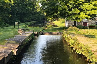
The Landsford Canal is a navigation channel that opened in 1823 with the purpose of bypassing rapids along the Catawba River to allow efficient freight transport and rapid travel between nearby communities and settlements along the rural frontiers of the era. It had five locks operating over a stretch of two miles (3.2 km) with an elevation change overall of 32–34 feet (9.8–10.4 m). It was part of the inland navigation system from the 'Up Country' to Charleston, built systematically from 1819, and the navigations are today the centerpiece of Canal State Park:
The Canal State Park consists of three sets of locks, a mill site, miller's house, and a lockkeeper's house—all in various forms of decay and ruins.
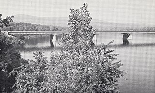
The Joseph E. Muller Bridge is a crossing of the Connecticut River in Western Massachusetts, connecting the communities of Holyoke and South Hadley. The bridge carries U.S. Route 202 (US 202).
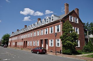
The Hadley Falls Company Housing District is a residential historic district encompassing a compact tract of factory worker housing in Holyoke, Massachusetts. Built in 1847-48, it is one of the earliest and largest surviving examples of company-built worker housing in the state. It includes five rowhouses facing Center, Lyman, Grover, and Canal Streets. The district was listed on the National Register of Historic Places in 1972.

The Holyoke Dam, also referred to as the Hadley Falls Dam, or Hadley Falls Station is a granite dam built in tandem with the Holyoke Canal System at Hadley Falls on the Connecticut River, between Holyoke and South Hadley, Massachusetts. The water differential created by the dam produced mechanical hydropower for industrial uses in Holyoke, and later hydroelectric power.

Bellows Falls Canal is a canal constructed to allow boat traffic to bypass Great Falls on the Connecticut River in Bellows Falls, Vermont. It was constructed by the Bellows Falls Canal Company and was one of the first canals in the United States. It was used for transport, to power mills, and later for hydroelectric power. The Bellows Falls Downtown Historic District includes the canal.


