Dartmouth is a coastal town in Bristol County, Massachusetts, United States. Old Dartmouth was the first area of Southeastern Massachusetts to be settled by Europeans in 1652, primarily English. Dartmouth is part of New England's farm coast, which consists of a chain of historic coastal villages, vineyards, and farms. June 8, 2014, marked the 350th year of Dartmouth's incorporation as a town. It is also part of the Massachusetts South Coast.
Fall River is a city in Bristol County, Massachusetts, United States. Fall River's population was 94,000 at the 2020 United States census, making it the tenth-largest city in the state. It abuts the Rhode Island state line with Tiverton, RI to its south.

Lakeville is a town in Plymouth County, Massachusetts, United States. The population was 11,523 at the 2020 census.
Middleborough is a town in Plymouth County, Massachusetts, United States. The population was 24,245 at the 2020 census. The census-designated place of Middleborough Center corresponds to the main village and commercial center of the town. It is the second largest municipality by land area in Massachusetts and nineteenth largest in New England. Middleborough proclaims itself to be the "Cranberry Capital of the World". Cranberry production remains a significant part of the local economy. In 2015, approximately 1,400 acres of the town were used to grow the crop, accounting for 3% of all land used to harvest cranberry bogs in the United States.

Rochester is a town in Plymouth County, Massachusetts, United States. The population was 5,717 at the 2020 census.

Lake Sabbatia, sometimes known as Scaddings Pond is a 248-acre (100 ha) great pond in Taunton, Massachusetts, near Watson Pond State Park. The lake is where Mill River begins and the Snake River ends. It is the largest lake in the city of Taunton and the most popularly used. There are several coves and an island within the lake. Parts of its coastline are populated with woods, streets, and residential homes. Lake Sabbatia is used for a variety of recreational activities such as boating, swimming, fishing, and ice fishing. There is a boat ramp off Bay Street into the lake.
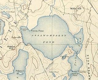
Assawompset Pond is a reservoir/pond within the towns of Lakeville and Middleboro, in southeastern Massachusetts. It shares its waters with Long Pond and is openly connected with Pocksha Pond. These lakes provide a source of drinking water to the city of New Bedford, the largest city in southeastern Massachusetts. At almost four square miles (10 km2), it is the largest natural lake in Massachusetts.
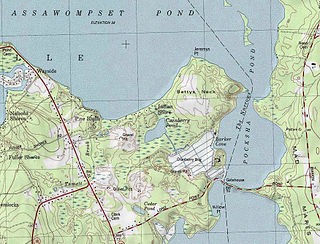
Pocksha Pond is a lake/reservoir/pond within the towns of Lakeville and Middleboro, in southeastern Massachusetts. It shares its waters with Great Quittacas Pond and openly connected with Assawompset Pond. These lakes provides a source of drinking water to the city of New Bedford, the largest city in southeastern Massachusetts.

Great Quittacas Pond is a lake, reservoir, or pond within the towns of Lakeville, Middleboro, and Rochester, in southeastern Massachusetts, United States. It shares its waters with Pocksha Pond and possibly nearby Little Quittacas Pond. These lakes provide a source of drinking water to the city of New Bedford, the largest city in southeastern Massachusetts.

Long Pond is a 1,721-acre (7.0 km2) lake within the towns of Lakeville and Freetown, in southeastern Massachusetts. It shares its waters with Assawompset Pond. These lakes provide a source of drinking water to the city of New Bedford, the largest city in southeastern Massachusetts. Long Pond is roughly one mile (1.6 km) wide by four miles (6.4 km) miles long, and contains three islands within its boundaries. In 1894 Assawompset Pond was dammed, increasing the water depth of Long Pond by about five feet (1.5 m). This created Nelson Island and caused Sunken Island to disappear due to erosion. All that remains of Sunken Island are the rocks in a shallow area just to the northwest of Lewis Island. Lewis Island is the largest of the three remaining islands today, containing sixteen privately owned cottages, while the second largest island, Nelson Island, was purchased in 2005 and now is a year-round private residence. The smallest island, Goat Island, was recently purchased from the Boy Scouts by a private citizen. Along the perimeter of the lake are many homes and private access points to the waterfront. Long Pond is well known for fishing and boating.

Massachusetts is the seventh-smallest state in the United States with an area of 10,555 square miles (27,340 km2). It is bordered to the north by New Hampshire and Vermont, to the west by New York, to the south by Connecticut and Rhode Island, and to the east by the Atlantic Ocean and Gulf of Maine. Massachusetts is the most populous New England state.

The South Coast of Massachusetts is the region of southeastern Massachusetts consisting of the southern part of Bristol and Plymouth counties, bordering Buzzards Bay, and includes the cities of Fall River, New Bedford, the southeastern tip of East Taunton and nearby towns. The Rhode Island towns of Tiverton and Little Compton, located in Newport County, are often included within the South Coast designation due to regional similarities with adjacent communities.

The Powwow River is a 22.8-mile-long (36.7 km) river located in New Hampshire and Massachusetts in the United States. It is a tributary of the Merrimack River, part of the Gulf of Maine watershed.

The Acushnet River is the largest river, 8.6 miles (13.8 km) long, flowing into Buzzards Bay in southeastern Massachusetts, in the United States. The name "Acushnet" comes from the Wampanoag or Algonquian word, "Cushnea", meaning "as far as the waters", a word that was used by the original owners of the land in describing the extent of the parcel they intended to sell to the English settlers from the nearby Plimouth colony. Quite naturally, the English mistook "Cushnea" for a fixed placename or the name of a specific river.
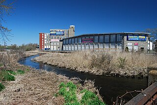
The Quequechan River is a river in Fall River, Massachusetts, that flows in a northwesterly direction from the northwest corner of the South Watuppa Pond through the heart of the city of Fall River and into the end of the Taunton River at Mount Hope Bay at Heritage State Park/Battleship Cove. The word Quequechan means "Falling River" or "Leaping/Falling Waters" in Wampanoag, hence the city's name.

Route 105 is a 29.36-mile-long (47.25 km) state highway in southeastern Massachusetts, running from Marion to Halifax in a generally north–south direction. Its southern terminus is at U.S. Route 6 in Marion and its northern terminus is at Route 106 in Halifax. Along the way it intersects Interstate 195 (I-195) in Marion and Interstate 495 and US 44 in Middleborough.
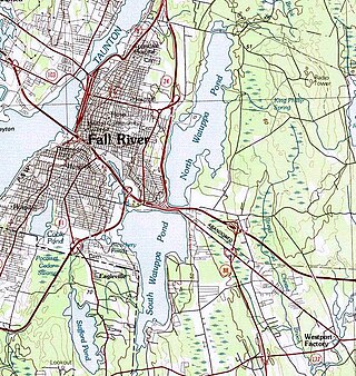
The Watuppa Ponds are two large, naturally occurring, spring-fed, glacially formed ponds located in Fall River and Westport, Massachusetts. Watuppa is a native word meaning "place of boats". The two ponds were originally one body of water, connected by a narrow rocky strait called "The Narrows" located on a thin strip of land between the two ponds which forms part boundary of between Fall River and Westport. The border between Fall River and Westport is also divided between the two ponds. Together, the ponds have an overall north–south length of about 7.5 miles, and have an average east–west width of about a mile. The ponds are drained by the Quequechan River, and flows in a westerly direction through the center of Fall River from South Watuppa Pond to Mount Hope Bay.

The Bay Circuit Trail and Greenway or Bay Circuit is a Massachusetts rail trail and greenway connecting the outlying suburbs of Boston from Plum Island in Newburyport to Kingston Bay in Duxbury, a distance of 200 miles (320 km).


