
The Segreganset River is a small river in Bristol County, Massachusetts that flows 9.6 miles (15.4 km) in a southeasterly direction through Taunton and Dighton into the Taunton River. Named tributaries include the Maple Swamp, Poppasquash Swamp, Sunken Brook and Cedar Swamp.
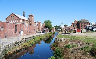
The Mill River is a tributary of the Taunton River that flows 4.0 miles (6.2 km) from Lake Sabbatia, through the center of Taunton, Massachusetts, to the Taunton River.
The Cotley River is a small river in Taunton and Berkley, Massachusetts that is a tributary of the Taunton River. It flows approximately 5.8 miles (9.2 km) in a northwesterly direction from the southeast part of Taunton near Seekell Street to Barstows Pond near the village of East Taunton where it joins the Taunton River.

The Three Mile River or Threemile River is a river in Bristol County, Massachusetts. It is formed by the junction of the Rumford and Wading rivers in the town of Norton. It flows in a southeasterly direction for 13.5 miles (21.7 km) through the towns of Norton, Taunton and Dighton, where it joins the Taunton River.

The Taunton River watershed or Taunton River basin is made up of 562 square miles (1,500 km2) of rivers, lakes, ponds, streams, and wetlands in southeastern Massachusetts, US. It is the second largest watershed in the state. Also, it is a significant part of a much larger multi-state watershed, the Narragansett Bay watershed.

Watson Pond is a small freshwater lake within Watson Pond State Park, in Taunton, Massachusetts, United States. The lake is connected to Lake Sabbatia and much of its coastline is forested. The lake is open to the public for swimming and ice fishing.

Lake Sabbatia, sometimes known as Scaddings Pond is a 248-acre (100 ha) great pond in Taunton, Massachusetts, near Watson Pond State Park. The lake is where Mill River begins and the Snake River ends. It is the largest lake in the city of Taunton and the most popularly used. There are several coves and an island within the lake. Parts of its coastline are populated with woods, streets, and residential homes. Lake Sabbatia is used for a variety of recreational activities such as boating, swimming, fishing, and ice fishing. There is a boat ramp off Bay Street into the lake.
The Hockomock Swamp is a vast wetland encompassing much of the northern part of southeastern Massachusetts. This 16,950-acre (6,859 ha) land is considered the largest freshwater swamp in the state. It acts as a natural flood control mechanism for the region.
The Satucket River is 5.5-mile-long (8.9 km) river in southeastern Massachusetts within the Taunton River Watershed. It flows generally west from Robbins Pond in East Bridgewater, and into the Matfield River.
The Wading River is a 13.1-mile-long (21.1 km) river in southeastern Massachusetts in the United States. It rises from Lake Miramichi in the town of Foxborough and flows southeast through Mansfield into the town of Norton, where it turns east, flows through Barrowsville Pond, and continues to its confluence with the Rumford River, forming the Three Mile River. The river is part of the Taunton River watershed.
The Shumatuscacant River is an 8.8-mile-long (14.2 km) river running through Abington and Whitman, Massachusetts. It forms part of the Taunton River Watershed.
The Canoe River is a river in southeastern Massachusetts. It is 14.4 miles (23.2 km) long and part of the Taunton River Watershed.

The Pocasset River is a small tidal river and estuary on the eastern shore of Buzzards Bay, in Bourne, Massachusetts, United States. It is located between the villages of Monument Beach and Pocasset along the western coast of Cape Cod. The river flows westward through a series of small ponds and wetlands, with a total length of about 2 miles (3.2 km).

Robbins Pond is a 124-acre (0.50 km2) warm water pond in East Bridgewater and Halifax, Massachusetts. It is part of the Taunton River Watershed. The inflow is Poor Meadow Brook, and the outflow is the Satucket River.The water is brown in color with a transparency of five feet, and the bottom is a mixture of sand and gravel. Average depth is four feet and maximum depth is just ten feet. There are 1.7 miles (2.7 km) of shoreline.

Winnecunnet Pond or Winneconnet Pond or Winnecunnett Pond, very often called Lake Winnecunnet or Lake Winneconnet or Lake Winnecunnett although it is a pond rather than a lake, is a body of water in Norton, Massachusetts, United States.

Tispaquin Pond is a 194-acre (0.79 km2) warm water pond in Middleborough, Massachusetts. The pond is in the Taunton River Watershed. The average depth of the pond is seven feet, and the maximum depth is eight feet. Transparency of the water is six feet. Shorts Brook and Woods Brook provide the inflow for the pond. The outflow is Fall Brook, a tributary of the Nemasket River. Camp Avoda and Camp Yomechas are located on the pond. Access to the southern shore of the pond is via Eldon Street off Rocky Gutter Street. An unpaved launch area is suitable for car top boats and canoes. It is a popular spot for recreational fishing, particularly for yellow perch and largemouth bass.

Norton is a town in Bristol County, Massachusetts, United States, and contains the villages of Norton Center and Chartley. The population was 19,202 at the 2020 census. Home of Wheaton College, Norton hosted the Dell Technologies Championship, a tournament of the PGA Tour held annually on the Labor Day holiday weekend at the TPC Boston golf club until 2018.

Back River is a small tidal estuary in Bourne, Massachusetts on the eastern shore of Buzzards Bay. It lies just south of the Cape Cod Canal near the village of Monument Beach. It is separated from Buzzards Bay by Phinneys Harbor. The river's length is 2.1 miles (3.4 km).
The Cedar Swamp River is a small river in Lakeville, Massachusetts that flows 4.6 miles (7.4 km) in a northwesterly direction through the western part of the town to where it forms the Assonet River near the Freetown line, just south of the village of Myricks. It is a tributary of the Taunton River.
The Salisbury Plain River is a 4.7-mile-long (7.6 km) river in Plymouth County, Massachusetts that flows from the city of Brockton into the towns of West Bridgewater and East Bridgewater where it joins the Matfield River, a major tributary of the Taunton River.
