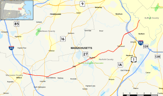
Stop River

Last updated
Stop River

Stop River (Medfield, Massachusetts) map.jpg

Stop River and environs
Physical characteristics
Main source Highland Lake, Walpole, MA
42°07′35″N71°18′20″W / 42.12639°N 71.30556°W / 42.12639; -71.30556
River mouth Charles River, Medfield, MA
42°10′25.2″N71°19′08.4″W / 42.173667°N 71.319000°W / 42.173667; -71.319000 Coordinates: 42°10′25.2″N71°19′08.4″W / 42.173667°N 71.319000°W / 42.173667; -71.319000
Length 9.3 miles (15.0 km)

The Stop River is a low and marshy stream in Medfield, Massachusetts, and partly forming the border between Norfolk and Walpole. The river rises near Highland Lake in Walpole, flows 9.3 miles (15.0 km) [1] northwards to join the Charles River in Medfield, and ultimately drains into Boston Harbor.

Medfield, Massachusetts Town in Massachusetts, United States

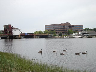
Medfield is a town in Norfolk County, Massachusetts, United States. The population is 12,024 according to the 2010 Census. It is a community about 17 miles southwest of Boston, Massachusetts, which is a 40-minute drive to Boston's financial district. Attractions include the Hinkley Pond and the Peak House.

Norfolk, Massachusetts Town in Massachusetts, United States

Norfolk is a town in Norfolk County, Massachusetts, United States, with a population of 11,227 people at the 2010 census. Formerly known as North Wrentham, Norfolk broke away to become an independent town in 1870.

Walpole, Massachusetts Town in Massachusetts, United States

Walpole is a town in Norfolk County, Massachusetts, United States and also encompasses the entirely distinct entity of Walpole (CDP), with its much smaller area of 2.9 square miles and smaller population of 5,198 at the 2010 census. Walpole Town, as the Census refers to the actual town, is located about 13 miles (21 km) south of Downtown Boston and 23.5 miles (37.8 km) north of Providence, Rhode Island. The population was 24,070 at the 2010 census. Walpole was first settled in 1659 and was considered a part of Dedham until officially incorporated in 1724. The town was named after Sir Robert Walpole, de facto first Prime Minister of Great Britain.

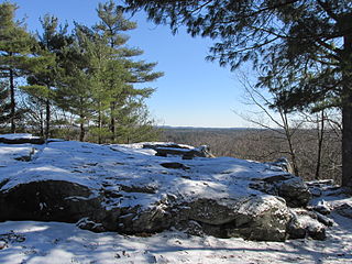
The Medfield Rhododendrons reservation, operated by The Trustees of Reservations, is an important and rare stand of Rhododendron maximum along the river in Woodridge Street, Medfield.

Medfield Rhododendrons

The Medfield Rhododendrons is a 196-acre (0.79 km2) nature reserve established in 1934 in Medfield, Massachusetts managed by the Trustees of Reservations. The site contains the largest area of Rhododendron maximum in the state, which are currently listed as threatened by the Massachusetts Natural Heritage and Endangered Species Program due to over-collecting.

The Trustees of Reservations

The Trustees of Reservations is a non-profit land conservation and historic preservation organization dedicated to preserving natural and historical places in the Commonwealth of Massachusetts. It is the oldest regional land trust in the world and as of 2016 has 125,000 dues-paying members. In addition to land stewardship, the organization is also active in conservation partnerships, community supported agriculture (CSA), environmental and conservation education, community preservation and development, and green building. The Trustees of Reservations own title to 116 properties on 27,000 acres (11,000 ha) in Massachusetts, all of which are open to the public; it maintains conservation restrictions on 200 more properties. Properties include historic mansions, estates, and gardens; woodland preserves; waterfalls; mountain peaks; wetlands and riverways; coastal bluffs, beaches, and barrier islands; farmland and CSA projects; and archaeological sites.

Related Research Articles

Neponset River river in the United States of America

The Neponset River is a river in eastern Massachusetts in the United States. Its headwaters are at the Neponset Reservoir in Foxborough, near Gillette Stadium. From there, the Neponset meanders generally northeast for about 29 miles (47 km) to its mouth at Dorchester Bay between Quincy and the Dorchester section of Boston, near the painted gas tank.

Rhododendron State Park

Rhododendron State Park in Fitzwilliam, New Hampshire, United States, is a 2,723-acre (11.02 km2) state park located on and around Little Monadnock Mountain, containing a 16-acre (65,000 m2) stand of native Rhododendron maximum, the largest of nineteen similar stands in central and northern New England, the northern limit of their growing range.

Massachusetts Route 27 highway in Massachusetts

Route 27 is a south–north highway in eastern Massachusetts that runs for 73.4 miles.

This article shows U.S. Census totals for Norfolk County, Massachusetts, broken down by municipality, from 1900 to 2000.

Francis William Bird Park

Francis William Bird Park is an 89-acre landscaped and waterscaped park located in Walpole, Massachusetts. The Trustees of Reservations owns and maintains the park. Features include over 3 miles (4.8 km) of walking and bicycle paths that wind through the park, traversing streams across granite bridges and passing through rolling lawns punctuated with mature shade trees, groves, and ponds.

Massachusetts Route 109 highway in Massachusetts

Route 109 is a state highway in eastern Massachusetts. It runs from Route 16 in Milford east to the VFW Parkway in Boston. Most of Route 109 runs along a portion of the Hartford and Dedham Turnpike.

Medfield Meadow Lots are a group of wetland meadows—Pratt Meadow, Perry Meadow, and Hinsdale Meadow—located in the Charles River floodplain within Medfield, Massachusetts, United States. The lots, totaling 16 acres (6.5 ha), are accessible by canoe or kayak only. They were acquired as an open space reserve via land donation by Henry L. Shattuck in 1968.

Bay Circuit Trail

The Bay Circuit Trail and Greenway or Bay Circuit is a Massachusetts recreational trail and greenway connecting the outlying suburbs of Boston from Plum Island in Newburyport to Kingston Bay in Duxbury, a distance of 200 miles (320 km).

Bridge Island Meadows is an 80-acre (320,000 m2) nature reserve owned by The Trustees of Reservations on the floodplains of the upper Charles River in Millis, Massachusetts. The property was a 1974 gift from Dr. and Mrs. John D. Constable to the Trustees of Reservations. The property is surrounded by wetlands, and is only accessible by boat.

Fork Factory Brook

Fork Factory Brook is a 135-acre historic site, open space reserve, and agricultural reserve located in Medfield, Massachusetts. The reserve, managed by the land conservation non-profit organization The Trustees of Reservations, is notable for its wetlands, ledges, 300-year-old hayfields, and ruins of a 19th-century pitchfork mill for which the property is named. Fork Factory Brook offers 1.5 miles (2.4 km) of trails and former woods roads available for hiking, horseback riding, mountain biking, and cross country skiing. The property is a spur link in the 200-mile (320 km) Bay Circuit Trail system and is part of a larger area of protected open space including the abutting Rocky Woods preserve, also managed by The Trustees of Reservations.

Lowell Holly Reservation

The Lowell Holly Reservation is a 135-acre (0.55 km2) nature reserve in Mashpee and Sandwich, Massachusetts and is managed by the Trustees of Reservations. The area was extensively planted by Abbot Lawrence Lowell and Wilfred Wheeler with rhododendrons, mountain laurel and holly trees, for which the reservation gets its name. There are 4 miles (6.4 km) of hiking trails and two peninsular knolls that jut into Mashpee Pond and Wakeby Pond. Abbot Lawrence Lowell bequeathed the property to the Trustees of Reservations in 1943.

Noon Hill (reservation)

Noon Hill is a 204-acre (83 ha) open space preserve located in Medfield, Massachusetts and centered on 370-foot (110 m) Noon Hill, a prominent summit and scenic vista. It is managed by the land conservation non-profit organization The Trustees of Reservations and offers 4.5 miles (7.2 km) of trails available for hiking, horseback riding, mountain biking, and cross country skiing. Oak-hickory forest, wetlands, vernal pools, steep ravines, boulders, and rocky ledges characterize the preserve. Noon Hill is a link in the 200-mile (320 km) Bay Circuit Trail. Holt Pond, a constructed mill pond, is located on the property.

Rocky Woods Protected landscape in Massachusetts

Rocky Woods is a 491-acre (199 ha) open space preserve located in Medfield, Massachusetts. The preserve, managed by the land conservation non-profit organization The Trustees of Reservations, is notable for its rugged terrain. Rocky Woods offers 6.5 miles (10.5 km) of trails and former woods roads available for hiking, horseback riding, mountain biking, dog walking, catch and release fishing, snowshoeing and cross country skiing. Rocky Woods is a spur link in the 200-mile (320 km) Bay Circuit Trail system. The preserve is part of a larger area of protected open space including the abutting Fork Factory Brook preserve, also managed by The Trustees of Reservations.

Dilijan National Park national park in Armenia

Dilijan National Park is one of the four national parks of Armenia. Occupying an area of 240 km², it is located in the north-eastern Tavush Province of Armenia. It is known for its forest landscapes, rich biodiversity, medicinal mineral water springs, natural and cultural monuments, and extensive network of hiking trails.

Medfield High School is a 9-12 public high school in Medfield, Massachusetts, part of Norfolk County, Massachusetts, United States. It is one of five public schools in the school system, and the only public high school in Medfield.

Shawn C. Dooley is an American politician from the Commonwealth of Massachusetts. He is a member of the Massachusetts House of Representatives in the 9th Norfolk district, succeeding Dan Winslow. The 9th Norfolk District constitutes all or parts of the Towns of Medfield, Millis, Norfolk, Plainville, Walpole, and Wrentham. A member of the Republican Party, he was sworn in January 29, 2014.

Childs Island is a small heavily forested island located north of the Stop River in the wetlands of Medfield Rhododendrons in Medfield, Massachusetts.

References

  1. U.S. Geological Survey. National Hydrography Dataset high-resolution flowline data. The National Map, accessed April 1, 2011