
The village of Pocasset is a census-designated place (CDP) in the town of Bourne in Barnstable County, Massachusetts, United States, located on Buzzards Bay. The population was 2,851 at the 2010 census.

The Lamprey River is a 50.2-mile-long (80.8 km) river in southeastern New Hampshire, the United States. It rises in Meadow Lake in Northwood, and flows south, then generally east through Raymond, Epping, Lee, Durham and finally Newmarket. Here, it meets Great Bay, a tidal inlet of the Atlantic Ocean, to which it is connected by a tidal estuary, the Piscataqua River. The river from the Bunker Pond Dam in Epping to the confluence with the Piscassic River is part of the designated National Wild and Scenic River System.
Bassetts Island is a "Y"-shaped island within Pocasset Harbor and Red Brook Harbor, in Bourne, Massachusetts, USA. 41-40’48” North x 070-38’13” West
The Lloyd Center for the Environment is a non-profit organization that provides educational programs on aquatic environments in southeastern New England in the United States.

The Acushnet River is the largest river, 8.6 miles (13.8 km) long, flowing into Buzzards Bay in southeastern Massachusetts, in the United States. The name "Acushnet" comes from the Wampanoag or Algonquian word, "Cushnea", meaning "as far as the waters", a word that was used by the original owners of the land in describing the extent of the parcel they intended to sell to the English settlers from the nearby Plimouth colony. Quite naturally, the English mistook "Cushnea" for a fixed placename or the name of a specific river.
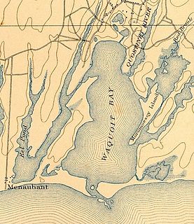
Waquoit Bay is a public national estuary, which is typically used as a research reserve. It is a part of Nantucket Sound and is located on the southern shore of Cape Cod in Massachusetts, USA. This bay forms the border of the towns of Falmouth and Mashpee, Massachusetts.
The Quequechan River is a river in Fall River, Massachusetts, that flows in a northwesterly direction from the northwest corner of the South Watuppa Pond through the heart of the city of Fall River and into the end of the Taunton River at Mount Hope Bay at Heritage State Park/Battleship Cove. The word Quequechan means "Falling River" or "Leaping/Falling Waters" in Wampanoag, hence the city's name.

Oyster Pond River, also called Oyster Creek, is a 1.7-mile-long (2.7 km) river in Chatham, Massachusetts on Cape Cod.

The Quashnet River, also known as Quoshnet River or Moonakis River, is a 5.1-mile-long (8.2 km) estuary in Falmouth, Massachusetts on Cape Cod. Its area is about 1-square-mile (2.6 km2).
The Childs River, also known as Child's River, is a 5.1-mile-long (8.2 km) river near Falmouth, Massachusetts on Cape Cod. Its drainage area is about 1-square-mile (2.6 km2). It has been heavily impacted by the development of cranberry bogs in its upper reaches.

The Canoe River is a river in southeastern Massachusetts. It is 14.4 miles (23.2 km) long and part of the Taunton River Watershed.

The Wankinco River is a 7.3-mile-long (11.7 km) river in eastern Massachusetts, United States. It is a tributary of the Wareham River, which drains into Buzzards Bay.

Popponesset Bay System is a group of bays located at the towns of Mashpee and Barnstable (east), on Cape Cod, Massachusetts with a southern shore bounded by water from Nantucket Sound.

The Agawam River is a 10.7-mile-long (17.2 km) stream in southeastern Massachusetts, USA, that is part of the Wareham River estuary watershed. The Agawam River is named in honor of the peaceful Native Americans that helped the Massachusetts Bay Colony establish its first Connecticut River Valley settlement at Springfield, Massachusetts in 1636, and helped it to flourish while many of the Connecticut Colony settlements south of Springfield were attacked or destroyed by more war-like Native American tribes.

The Mattapoisett River is an 11.6-mile-long (18.7 km) river in southeastern Massachusetts, in the United States.

The Weweantic River is a 17.0-mile-long (27.4 km) river in southeastern Massachusetts. Its name means "crooked" or "wandering stream" in the Wampanoag language.
West Wind Shores is a small village in Plymouth, Massachusetts, United States. It is located south of Long Pond and north of Buzzards Bay, Whites Pond, Little Sandy Pond, Big Sandy Pond, and Ezekiel Pond. The village is built around several small ponds.
On Sunday April 27, 2003, the Tank Barge Bouchard No. 120 struck rocks south of Westport, Massachusetts. This resulted in a puncture of the barge's hull about twelve feet in length. As a result, the cargo of the barge, number 6 fuel oil, spilled into the waters of Buzzards Bay, Massachusetts. While the spill was much smaller than many oil spills, the environmental impacts were felt for years. Estimates of the total amount spilled range from 22,000 to 98,000 gallons of oil according to a publication by the National Oceanic and Atmospheric Administration.

Weir River is a short stream and estuary that empties into Hingham Bay, part of Boston Harbor in Massachusetts, United States. The name is attributed to the location of a fishing weir in the stream. The river gives its name to a larger watershed and Weir River Farm, a park and nature reserve owned by The Trustees of Reservations.
The Back River is a small tidal estuary in Bourne, Massachusetts on the eastern shore of Buzzards Bay. It lies just south of the Cape Cod Canal near the village of Monument Beach. It is separated from Buzzards Bay by Phinneys Harbor. The river's length is 2.1 miles (3.4 km).
