Related Research Articles
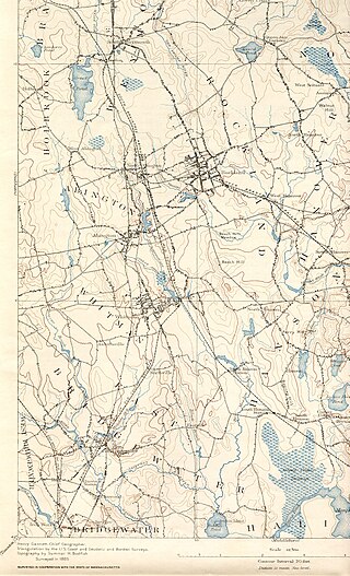
The Matfield River is a 6.3-mile-long (10.1 km) river in Plymouth County, Massachusetts. It flows south through the town of East Bridgewater to a confluence with the Town River, forming the Taunton River. The Matfield River, where it flows through the historic village of Elmwood and flows under Route 18, is commonly known as the Elmwood River.
The Egypt River is a stream in Ipswich, Massachusetts, United States.
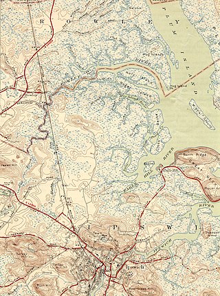
The Rowley River is a small river between Ipswich and Rowley, Massachusetts.
The Shumatuscacant River is an 8.8-mile-long (14.2 km) river running through Abington and Whitman, Massachusetts. It forms part of the Taunton River Watershed.
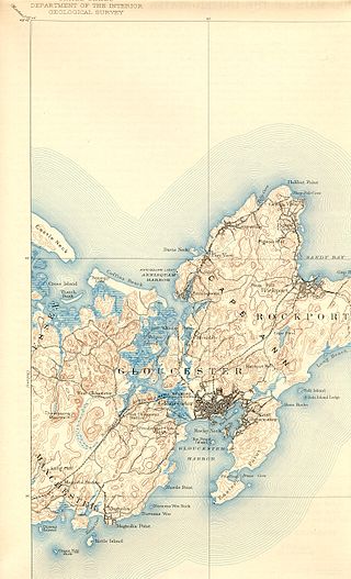
The Annisquam River is a tidal, salt-water estuary in the Annisquam neighborhood of Gloucester, Massachusetts, connecting Annisquam Harbor on the north to Gloucester Harbor on the south. The segment between Gloucester Harbor and the Newburyport/Rockport Line bridge is also known as the Blynman Canal.
The Roger Island River is a small tidal estuary between Ipswich and Rowley, Massachusetts. It is a southern branch of the larger Rowley River passing around Roger Island.
Jacobs Hill is a 173-acre (70 ha) open space preserve in Royalston, Massachusetts acquired in 1975 by the land conservation non-profit organization The Trustees of Reservations. The preserve includes scenic vistas, ledges, woodlands, a northern bog, and Spirit Falls, a 30 foot (9.1 m) waterfall. The 22-mile (35 km) Tully Trail passes through the property. Views from the ledges include the Berkshires as well as nearby Long Pond and the Tully River Valley, Tully Mountain, and Mount Grace.
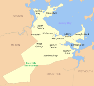
Adams Shore is a neighborhood of Quincy, Massachusetts. It is located on the shore of Quincy Bay at the entrance to the Hough's Neck peninsula. It is bordered on the north by Quincy Bay, on the east by the Hough's Neck neighborhood, on the south by Town River Bay and on the west by the Merrymount neighborhood. According to the U.S. Census Bureau, in 2000 the population of Adams Shore was just over 1,500.

Northshore Academy Upper School is a public alternative high school in Beverly, Massachusetts, United States, serving students in grades 7–12. It is a school for the specials.

Weir River is a short stream and estuary that empties into Hingham Bay, part of Boston Harbor in Massachusetts, United States. The name is attributed to the location of a fishing weir in the stream. The river gives its name to a larger watershed and Weir River Farm, a park and nature reserve owned by The Trustees of Reservations.
Fort Nichols was a fort that existed in 1775 in Amesbury, Massachusetts during the American Revolutionary War. It was also known as Fort Merrimac during its existence. Two possible locations for the fort exist. One is a location named Salisbury Point on modern topographic maps, where Interstate 95 crosses the Merrimack River; this is the location of the coordinates given. Another possibility is the mouth of the Merrimack at Salisbury Beach in Salisbury. One source (Heitman) states that the American Civil War Fort at Salisbury Point was built at the same location as Fort Nichols, which is given as "at Salisbury Point, opposite Newburyport". The Civil War fort was sometimes referred to as Fort Nichols by local civilians.
Castle Rock is a barren, uninhabited island located in Nahant Bay in Nahant, Massachusetts.
Chubb Island is a small barren island located in Manchester Bay in Beverly, Massachusetts.
Corn Island is a forested island of Essex County, Massachusetts.
Coney Island is an abandoned island located in Massachusetts Bay in Salem, Massachusetts. It has light growth, with a small salt marsh.
Dole Island is an island located in the Parker River in Newbury, Massachusetts. The Parker River National Wildlife Refuge is located on it.
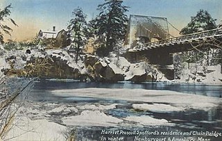
Deer Island is a small island with only 1-2 residences, located in the Merrimack River in Amesbury, Massachusetts. The island connects to mainland Amesbury by way of the Derek S. Hines Memorial Bridge, and to neighboring Newburyport via Chain Bridge.
Schenob Brook is a stream in Berkshire County, Massachusetts and Litchfield County, Connecticut, in the United States. Variant names are Kisnop Brook, Schenop Brook, and Skerrob Brook.
Marblehead Rock is an island off Marblehead, Massachusetts.

The Artichoke River, is a tributary of the Merrimack River in Massachusetts in the United States. It is in Essex County, Massachusetts, and flows generally north, marking the boundary between West Newbury and Newburyport. The Upper and Lower Artichoke reservoirs are impoundments of the river that acts as a water source for nearby towns. Despite the short length of the river, there are three dams along its course, the Emory Lane Dam, the Lower Artichoke Dam and the Upper Artichoke Dam. The river is named for the Jerusalem Artichoke, which had been harvested nearby by Native Americans and early settlers.
References
42°13′31″N70°55′18″W / 42.22523°N 70.92163°W
| | This Norfolk County, Massachusetts geography–related article is a stub. You can help Wikipedia by expanding it. |
| | This Plymouth County, Massachusetts geography–related article is a stub. You can help Wikipedia by expanding it. |