East Kingston is a town in Rockingham County, New Hampshire, United States. The population was 2,441 at the 2020 census.

Kingston is a town in Rockingham County, New Hampshire, United States. The population at the 2020 census was 6,202.

Newton is a town in Rockingham County, New Hampshire, United States. The population was 4,820 at the 2020 census.

South Hampton is a town in Rockingham County, New Hampshire, United States. The population was 894 at the 2020 census. South Hampton is home to Cowden State Forest and Powwow River State Forest.
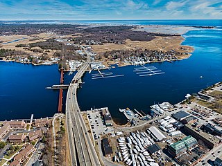
The Merrimack River is a 117-mile-long (188 km) river in the northeastern United States. It rises at the confluence of the Pemigewasset and Winnipesaukee rivers in Franklin, New Hampshire, flows southward into Massachusetts, and then flows northeast until it empties into the Gulf of Maine at Newburyport. From Pawtucket Falls in Lowell, Massachusetts, onward, the Massachusetts–New Hampshire border is roughly calculated as the line three miles north of the river.
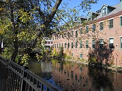
Amesbury is a city in Essex County, Massachusetts, United States, located on the left bank of the Merrimack River near its mouth, upstream from Salisbury and across the river from Newburyport and West Newbury. The population was 17,366 at the 2020 United States Census. A former farming and mill town, Amesbury is today largely residential. It is one of the two northernmost towns in Massachusetts.
The Pemigewasset River, known locally as "The Pemi", is a river in the state of New Hampshire, the United States. It is 65.0 miles (104.6 km) in length and drains approximately 1,021 square miles (2,644 km2). The name "Pemigewasset" comes from the Abenaki word bemijijoasek [bəmidzidzoasək], meaning "where side (entering) current is".

Country Pond is a 306-acre (124 ha) water body located in Rockingham County in southern New Hampshire, United States, in the towns of Kingston and Newton. Water from Country Pond flows via the Powwow River to the Merrimack River in Amesbury, Massachusetts.

The Spicket River is a 17.7-mile-long (28.5 km) river located in New Hampshire and Massachusetts in the United States. It is a left tributary of the Merrimack River, part of the Gulf of Maine watershed. It is sometimes spelled "Spickett".

Maudslay State Park is a Massachusetts state park located in Newburyport. The park is managed by the Department of Conservation and Recreation. It is available for weddings and other programs.
The Lane River is an 8.5-mile-long (13.7 km) stream in central New Hampshire in the United States. It is a tributary of the Warner River, part of the Contoocook River watershed.
The Back River is a 6.5-mile-long (10.5 km) river located in New Hampshire and Massachusetts in the United States. It is a tributary to the Powwow River, part of the Merrimack River watershed. Approximately 3.0 miles (4.8 km) of the river are in New Hampshire, with the remaining 3.5 miles (5.6 km) in Massachusetts.
The Red Hill River is a 6.5-mile-long (10.5 km) river in the Lakes Region of central New Hampshire in the United States. It is a tributary of Lake Winnipesaukee, part of the Merrimack River watershed.
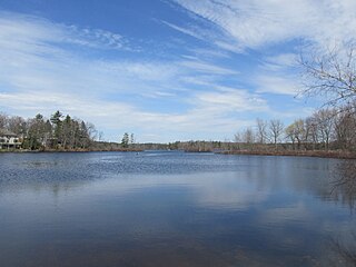
Great Pond is a 268-acre (1.08 km2) water body in Rockingham County in southeastern New Hampshire in the United States. The lake lies near the center of the town of Kingston. Kingston State Park, a small preserve with a swimming beach, occupies the northeastern end of the lake, near the town center. The lake is located along the Powwow River, a tributary of the Merrimack River.

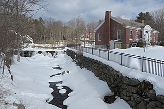
Powwow Pond is a 348-acre (1.41 km2) water body in Rockingham County in southeastern New Hampshire, United States. It is classified as an artificial impoundment. The outlet of the pond is located in the town of East Kingston, but most of the lake lies in the town of Kingston. The Powwow River, the outlet of the pond, flows to the Merrimack River in Amesbury, Massachusetts.

Hopkins Pond is a small pond located at the south foot of Ragged Mountain, in the town of Andover, New Hampshire, United States. It lies at an elevation of 644 feet (196 m). The pond is part of Proctor Academy's 2,500-acre (10 km2) campus in Andover and is jointly managed by Proctor and the New Hampshire Fish and Game Department. The pond area is open to the public for non-motorized boat travel, fishing and hiking.

The Merrimack Valley is a bi-state region along the Merrimack River in the U.S. states of New Hampshire and Massachusetts. The Merrimack is one of the larger waterways in New England and has helped to define the livelihood and culture of those living along it for millennia.

Silvio O. Conte National Fish and Wildlife Refuge was established in 1997 to conserve, protect and enhance the abundance and diversity of native plant, fish and wildlife species and the ecosystems on which they depend throughout the 7,200,000-acre (29,000 km2) Connecticut River watershed. The watershed covers large areas of Vermont, New Hampshire, Massachusetts and Connecticut. It contains a great diversity of habitats, notably: northern forest valuable as nesting habitat for migrant thrushes, warblers and other birds; rivers and streams used by shad, salmon, herring, the endangered shortnose sturgeon and other migratory fishes; and an internationally significant complex of high-quality tidal fresh, brackish and salt marshes.

Willard Pond is a small, protected lake in Antrim, New Hampshire, United States. The lake, located in southwestern New Hampshire, is about 108 acres (44 ha) in size with an average depth of 25 feet (7.6 m) and a maximum depth of 58 feet (18 m). No petroleum motors are allowed, and fly fishing is the only form of fishing allowed. It is part of the dePierrefeu Wildlife Sanctuary, which is owned by the New Hampshire Audubon Society. Because the pond and the land around it are part of the sanctuary, the shore is unable to be developed. Therefore, there are no buildings around the pond and there won't be in the foreseeable future. Willard is instead surrounded by extensive amounts of wilderness and hiking trails that lead around the pond and to the summits of Bald Mountain and Goodhue Hill. Willard is a popular fishing, boating and hiking destination, and it has become more popular with its mention in numerous magazines and newspapers.