Ipswich River

Last updated
Ipswich River
IpswichRiver.JPG
The Ipswich River from a footbridge in
Bradley Palmer State Park, October 2007
Location
Country United States
Physical characteristics
Source 
  location Burlington, Massachusetts
  coordinates 42°33′14″N71°08′38″W / 42.5539828°N 71.1439441°W / 42.5539828; -71.1439441
Mouth  
  location
Ipswich Bay, Massachusetts
  coordinates
42°41′38″N70°47′23″W / 42.6939825°N 70.7897712°W / 42.6939825; -70.7897712 Coordinates: 42°41′38″N70°47′23″W / 42.6939825°N 70.7897712°W / 42.6939825; -70.7897712
Length35 mi (56 km)
Basin size155 sq mi (400 km2)
Basin features
Tributaries 
  left Skug River, Boston Brook
  right Miles River, Salem Beverly Waterway Canal

Ipswich River is a small river in northeastern Massachusetts, United States. It held significant importance in early colonial migrations inland from the ocean port of Ipswich. The river provided safe harborage at offshore Plum Island Sound to early Massachusetts subsistence farmers, who were also fishermen. A part of the river forms town boundaries and divides Essex County, Massachusetts on the coast from the more inland Middlesex County. [1] It is 35 miles (56 km) long, [2] and its watershed is approximately 155 square miles (401 km2), with an estimated population in the area of 160,000 people. [3]

Contents

Historically, the settlement of Essex County began at the oldest community there, the tiny seaport of Agawam (later renamed Ipswich, and not to be confused with present-day Agawam in Hampden County), and typically proceeded westward and northward along the Ipswich or its tributary creeks. When Middlesex County was formed in the Massachusetts Bay Colony, only Salem and Charlestown across the Charles River mouth and Boston harbor's inner estuary from Boston's much smaller hill dominated peninsula were older settlements.

The upper river runs through and drains at least parts of Burlington, the lower river forms part of the borders between the towns of:

  1. North Reading and Lynnfield
  2. Middleton and the city of Peabody
  3. Middleton and Danvers, and
  4. Boxford and Topsfield.

The wide swamps along the river made it impossible to ford the stream anywhere east of Wilmington in colonial times. The only route north out of Boston to the northeast (today called the North Shore) was via the Andover Road, an often muddy track, later made a wagon road which forded the stream just below the confluence of Lubbers and Maple Meadow brooks.

Geology

The topography of eastern Massachusetts was determined most by the fact that, at the maximum glaciation of the Pleistocene Era, it was the site of the edge of the last glaciation, at approximately 18,000 BC. This glacier had planed the land under it nearly flat. Gravel- and boulder-lined streams ran along its surface. From 18,000 to about 10,000 BC, the glacier receded, dropping its stony contents as eskers and moraines, the dominant features of the region. The glacier's recession created ridges, deposited sand and gravel, the dominant material of the riverbed, over which mud has been deposited. [4] Low-gradient drainage created the meandering streams, which typically drop no more than 30–40 feet.

Usage

The first written record about the Ipswich River is from 1638 when John Winthrop bought from Chief Masconomet and the Agawam tribe the lands along the river and exclusive fishing rights for 20 pounds sterling.

Most of the land along the river is privately owned but in certain recreational areas non-motorized boats, fishing, and swimming are allowed. It is attractive to canoeists and birders. In the swampy and wetland areas a wide variety of birds and smaller wildlife species can be seen.

Drinking water for many communities is provided from Ipswich River. It is estimated that source of public drinking water for approximately 350,000 people comes from the river's watershed although most of these people live outside the area. There are some concerns about the quality of the water as the river dries up and some places become a dumping ground for tires. [5]

Geography

This 1893 USGS topographical map shows the middle regions of the Ipswich River draining left to right, alongside which are the more noticeable railways of yesteryear. USGS Lawrence, MA-NH 15 minute Quadrangle SE (1893).jpg
This 1893 USGS topographical map shows the middle regions of the Ipswich River draining left to right, alongside which are the more noticeable railways of yesteryear.

The river begins in the northeastern part of Burlington in northcentral Middlesex County Massachusetts and heading generally southeasterly, it passes through the towns of Wilmington (where once the important Middlesex Canal passed over it on an aqueduct), Reading, thence to North Reading, where it is joined by the left bank tributary Skug River which originates in North Andover and Andover southwest of Boston Hill in a large Beaver Pond and marshland, situated north of Gray Road-jct.-Gray Street (very near the townlines of the two towns) where it crosses via culvert south of Rt. MA 125 and west of Rt. MA 114 (historically, and by street name, the Salem Turnpike), and thence, about a mile south, gains volume draining all of Harold Parker State Forest in the tri-town corner of Andover, North Andover, and Middleton excepting the few acres draining to Ipswich tributary, Boston Brook along the other side of MA 114.

Both tributary creeks enter and mingle with the Ipswich proper in Middleton, proceed south into northern Peabody, then loop northwards through the municipalities of Danvers,Topsfield (crossing US Route 1 just south of the Topsfield Fairground, entering from the west turns northerly and runs the greater length of Teal Pond southwest to north, the east bank of which forms a part of the western border of Hamilton, and exits the lake turning easterly staying south of Ipswich Road to head through and between the Willowdale State Forest and Bradley Palmer State Park, then opens a gap from Ipswich road diverging southeasterly from the road and the south edge of the Turner Hill Golf Club to turn north and form the west border of the Julia Bird Reservation thence meanders north through settled Ipswich neighborhoods and directly through town center passing under MA 133 (County Road, aka. South Main Street) where it gradually begins widening until a mile beyond main Street it passes Nichols Field and the salt marsh floodplain begins. From Nichols it traverses a bit over 2.5 miles (4.0 km) [6] joins with Plum Island Sound in connecting with the Atlantic Ocean at Ipswich Bay. [7] There is always some flow from the river into the bay. However, the lower Ipswich and Plum Island Sound, as well as the lower four other rivers flowing into it, and the much larger Merrimack River to the north, are all tidal estuaries, so the water is brackish from mixing ocean born saltwater inland during flood tides, and the lands immediately along the banks, where not inundated some of the time, are nonetheless saturated by brackish water and support only hearty plants capable of tolerating the waters such as salt marsh hay. High tides cover all of Great Marsh and the flood plains of the lower rivers. Low tides uncover the mud flats, reducing the deep channels to small streams some often small enough one can hop across to fish elsewhere.

The river is navigable upstream to nearly Ipswich center by small craft. There a sharper drop in elevation over some rocky areas upstream characteristic of Northeastern US streams in general and which prevents further navigation without portaging light boats. The river and riverlands currently suffer from diminished flow due to extensive withdrawals from the ground water in urban areas upstream.[ citation needed ] The upper third of the river may become a dry bed in the summer. Wetland reservations, for wildlife have been created along much of the lower river and the mean water level therein has been prevented from falling precipitously by Willowdale Mill Dam, a remnant of a 19th-century mill system. It is currently privately owned by a canoe-rental concession.

Mouth of the Ipswich River
in Ipswich Bay, July 2010 Ipswich river mouth.JPG
Mouth of the Ipswich River
in Ipswich Bay, July 2010

The combined Ipswich River/Plum Island Sound exits through a relatively narrow, shallow channel that passes under Castle Hill and along Crane's Beach to the south. On the north, Sandy Point at the tip of Plum Island juts into the flow. In the days of sail, Bar Head, Bar Head Rocks, and Emerson Rocks posed some threat to sailing vessels trying to tack into or out of the estuary. The shallow waters often stranded vessels in storms, which would then be dismantled by severe breakers. The combination was inevitably tragic to vessels caught there in a northeaster, or violent winter storm of near-hurricane-force winds. Despite these difficulties, the sound and the mouth of the Ipswich were mooring places of ocean-going cargo vessels and fishing and whaling boats, before the opening of Newburyport Harbor, then blocked by a sandbar. The now abandoned shores of the region give little hint of its former importance to commerce and prosperity.

See also

Related Research Articles

<span class="mw-page-title-main">Essex County, Massachusetts</span> County in Massachusetts, United States

Essex County is a county in the northeastern part of the U.S. state of Massachusetts. At the 2020 census, the total population was 809,829, making it the third-most populous county in the state, and the eightieth-most populous in the country. It is part of the Greater Boston area. The largest city in Essex County is Lynn. The county was named after the English county of Essex. It has two traditional county seats: Salem and Lawrence. Prior to the dissolution of the county government in 1999, Salem had jurisdiction over the Southern Essex District, and Lawrence had jurisdiction over the Northern Essex District, but currently these cities do not function as seats of government. However, the county and the districts remain as administrative regions recognized by various governmental agencies, which gathered vital statistics or disposed of judicial case loads under these geographic subdivisions, and are required to keep the records based on them. The county has been designated the Essex National Heritage Area by the National Park Service.

<span class="mw-page-title-main">Middleton, Massachusetts</span> Town in Massachusetts, United States

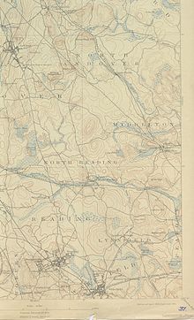
Middleton is a town in Essex County, Massachusetts, United States. The population was 9,779 at the 2020 census.

<span class="mw-page-title-main">Newbury, Massachusetts</span> Town in Massachusetts, United States

Newbury is a town in Essex County, Massachusetts, USA. The population was 6,716 at the 2020 census. Newbury includes the villages of Old Town, Plum Island and Byfield. Each village is a precinct with its own voting district, various town offices, and business center.

<span class="mw-page-title-main">North Andover, Massachusetts</span> Town in Massachusetts, United States

North Andover is an affluent town in Essex County, Massachusetts, United States. At the 2020 census the population was 30,915.

<span class="mw-page-title-main">Merrimack River</span> River in New Hampshire and Massachusetts, United States

The Merrimack River is a 117-mile-long (188 km) river in the northeastern United States. It rises at the confluence of the Pemigewasset and Winnipesaukee rivers in Franklin, New Hampshire, flows southward into Massachusetts, and then flows northeast until it empties into the Gulf of Maine at Newburyport. From Pawtucket Falls in Lowell, Massachusetts, onward, the Massachusetts–New Hampshire border is roughly calculated as the line three miles north of the river.

<span class="mw-page-title-main">Boxford, Massachusetts</span> Town in Massachusetts, United States

Boxford is a town in Essex County, Massachusetts, United States. According to the U.S. Census Bureau, the town's population was 8,203 in 2020.

<span class="mw-page-title-main">Ipswich, Massachusetts</span> Town in Massachusetts, United States

Ipswich is a coastal town in Essex County, Massachusetts, United States. The population was 13,785 at the 2020 census. Home to Willowdale State Forest and Sandy Point State Reservation, Ipswich includes the southern part of Plum Island. A residential community with a vibrant tourism industry, the town is famous for its clams, celebrated annually at the Ipswich Chowderfest, and for Crane Beach, a barrier beach near the Crane estate. Ipswich was incorporated as a town in 1634.

<span class="mw-page-title-main">Topsfield, Massachusetts</span> Town in Massachusetts, United States

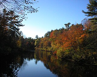
Topsfield is a town in Essex County, Massachusetts, United States. The population was 6,569 at the 2020 census. Topsfield is located in the North Shore region of Massachusetts. Part of the town comprises the census-designated place of Topsfield.

<span class="mw-page-title-main">Concord River</span> River in Massachusetts, United States

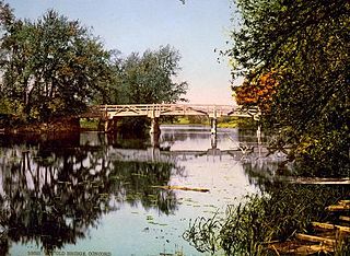
The Concord River is a 16.3-mile-long (26.2 km) tributary of the Merrimack River in eastern Massachusetts in the United States. The river drains a small rural and suburban region northwest of Boston. One of the most famous small rivers in U.S. history, it was the scene of an important early battle of the American Revolutionary War and was the subject of a famous 19th-century book by Henry David Thoreau.

Massachusetts's 6th congressional district is located in northeastern Massachusetts. It contains most of Essex County, including the North Shore and Cape Ann, as well as part of Middlesex County. It is represented by Seth Moulton, who has represented the district since January 2015. The shape of the district went through minor changes effective from the elections of 2012 after Massachusetts congressional redistricting to reflect the 2010 census. The towns of Tewksbury and Billerica were added, along with a small portion of the town of Andover.

The Massachusetts Highway Department was the highway department in the U.S. state of Massachusetts from 1991 until the formation of the Massachusetts Department of Transportation (MassDOT) in 2009.

The Jewish Journal is an independent, community-sponsored Jewish newspaper serving the Jewish community of Essex County, Massachusetts north of Boston, and published bi-weekly on Fridays since 1976. It is managed by a Board of Overseers representing points of view of the entire Jewish community.

<span class="mw-page-title-main">Bradley Palmer State Park</span>

Bradley Palmer State Park is a public recreation area covering 736 acres (298 ha) on the Ipswich River in the towns of Hamilton and Topsfield, Massachusetts. The state park was once the estate of noted attorney Bradley Palmer. In addition to an extensive system of multi-use trails, the park features Palmer's restored Willowdale Mansion. The mansion is now home to Willowdale Estate, a premier event venue. Bordered on the north by the Ipswich River and Willowdale State Forest, the park is managed by the Department of Conservation and Recreation.

<span class="mw-page-title-main">Wenham Lake</span> Body of water

Wenham Lake is a 224-acre body of water located in Wenham and Beverly towns, Essex County, Massachusetts.The lake receives water from the water table and also from a system of streams. In the 19th century, the lake was an important source of ice for export, especially to Britain. Wenham Lake is now a reservoir for the Salem and the Beverly Water Supply Board.

Codorus Creek is a 42.4-mile-long (68.2 km) tributary of the Susquehanna River in York County, Pennsylvania in the United States.

<span class="mw-page-title-main">Bay Circuit Trail</span> Long-distance hiking trail in the United States

The Bay Circuit Trail and Greenway or Bay Circuit is a Massachusetts rail trail and greenway connecting the outlying suburbs of Boston from Plum Island in Newburyport to Kingston Bay in Duxbury, a distance of 200 miles (320 km).

Masconomet, spelled many different ways in colonial deeds, was sagamore of the Agawam tribe among the Algonquian peoples during the time of the English colonization of the Americas. He is known for his quitclaim deed ceding all the tribal land, which extended from Cape Ann to the Merrimack River, as far inland as North Andover, Massachusetts and Middleton, Massachusetts, and as far to the southwest as the Danvers River, to John Winthrop the Younger, his heirs and all the settlers of eastern Essex County for a sum of 20 pounds, about 100 dollars.

<span class="mw-page-title-main">Samuel Phillips (minister)</span>

Samuel Phillips was an American Congregational minister and the first pastor of the South Church in Andover, Massachusetts. His son, John Phillips, was the founder of Phillips Exeter Academy, and his grandson, Samuel Phillips Jr., was the founder of Phillips Academy Andover and briefly the lieutenant governor of Massachusetts.

The 155th Massachusetts General Court, consisting of the Massachusetts Senate and the Massachusetts House of Representatives, met from January 1, 1947, to June 18, 1948, during the governorship of Robert F. Bradford, in Boston.

<span class="mw-page-title-main">Massachusetts House of Representatives' 4th Essex district</span> American legislative district

Massachusetts House of Representatives' 4th Essex district in the United States is one of 160 legislative districts included in the lower house of the Massachusetts General Court. It covers part of Essex County. Democrat Estela Reyes has represented the district since 2023.

References

  1. U.S. Geological Survey Geographic Names Information System: Ipswich River
  2. "The National Map - National Hydrography Dataset high-resolution flow line data". viewer.nationalmap.gov. United States Geological Survey. Archived from the original on 2012-03-29. Retrieved 1 Apr 2011.
  3. "Ipswich River Watershed". mass.gov. Massachusetts Executive Office of Environmental Affairs. Archived from the original on 29 September 2007. Retrieved 8 Jan 2017.
  4. "About the River and Watershed". ipswichriver.org. Ipswich River Watershed Association. Archived from the original on 7 February 2010. Retrieved 8 Jan 2017 via web.archive.org.
  5. Kirk, Bill. "Water shortage hits home upstream". Salem Evening News . Archived from the original on 26 November 2006. Retrieved 8 Jan 2017 via net1plus.com by way of web.archive.org.
  6. 2.5 mile measurement and previous like descriptions are approximate satellite generated data using the google.com/maps/place ruler tool with google maps in terrain mode zoomed way in to show watercourses.
  7. "About the Ipswich River". naturecompass.org. Archived from the original on 27 May 2010. Retrieved 8 Jan 2017 via web.archive.org.

Commons-logo.svg Media related to Ipswich River at Wikimedia Commons