
Detroit Dam is a gravity dam on the North Santiam River between Linn County and Marion County, Oregon. It is located in the Cascades, about 5 mi (8.0 km) west of the city of Detroit. It was constructed between 1949 and 1953 by the United States Army Corps of Engineers. The dam created 400-foot (120 m) deep Detroit Lake, more than 9 miles (14 km) long with 32 miles (51 km) of shoreline.

The RCA Dome was a domed stadium in Indianapolis. It was the home of the Indianapolis Colts NFL franchise for 24 seasons (1984–2007).
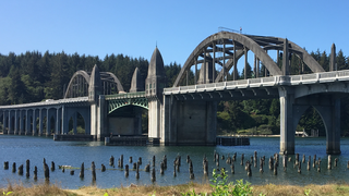
The Siuslaw River Bridge is a bascule bridge that spans the Siuslaw River on U.S. Route 101 in Florence, Oregon. It was designed by Conde McCullough, built by the Mercer-Fraser Company of Eureka, California, and funded by the Federal Emergency Administration of Public Works. It opened in 1936.
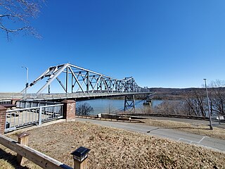
The Rip Van Winkle Bridge is a cantilever bridge spanning the Hudson River between Hudson, New York and Catskill, New York. The structure carries NY 23 across the river, connecting US 9W and NY 385 on the west side with NY 9G on the east side. The bridge is named after the 1819 short story of the same name by Washington Irving, which mentions Hudson and Catskill.

Maine Yankee Nuclear Power Plant was a nuclear power plant built at an 820-acre site on Bailey Peninsula of Wiscasset, Maine, in the United States. It operated from 1972 until 1996, when problems at the plant became too expensive to fix. It was decommissioned and dismantled between 1997 and 2005, though some of the plant's nuclear waste is still stored on site, pending final disposal.

The Glass Bowl is a stadium in Toledo, Ohio. It is primarily used for American football, and is the home field of the American football team of the University of Toledo Rockets. It is located on the school's Bancroft campus, just south of the banks of the Ottawa River. Known for its blend of old and new, it retains the traditional stonework around the field throughout all its expansions.

Desert Financial Arena is a 14,000-seat multi-purpose arena located at 600 E Veterans Way in Tempe, Arizona, a suburb of Phoenix. It sits immediately east of Sun Devil Stadium on the northern edge of the Tempe campus of Arizona State University (ASU).

The University Center is a 7,500-seat multi-purpose arena in Hammond, Louisiana, United States, on the campus Southeastern Louisiana University. Often called "the UC" within the University, it was built in 1982 at a cost of $16.3 million.
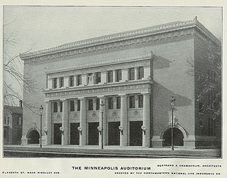
Minneapolis Auditorium was an indoor arena in Minneapolis, Minnesota. It hosted the NBA's Minneapolis Lakers from 1947 until they moved to the Minneapolis Armory in 1959. The arena held 10,000 people and was built in 1927. The building fell into obscurity after the opening of the Met Center in suburban Bloomington. It was demolished in 1988 to make way for the Minneapolis Convention Center.
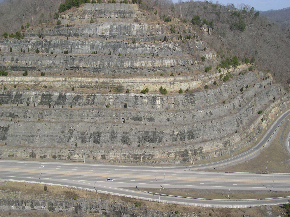
The Pikeville Cut-Through is a rock cut in Pikeville, Kentucky, United States, created by the U.S. Army Corps of Engineers, through which passes a four-lane divided highway, a railroad line, and the Levisa Fork of the Big Sandy River. It is one of the largest civil engineering projects in the western hemisphere, moving nearly 18,000,000 cubic yards (14,000,000 m3) of soil and rock, compared to the Big Dig and the Panama Canal. Dr. William Hambley, who served as mayor of Pikeville for 29 years, Robert H. Holcomb, Chamber of Commerce president, and Henry Stratton, local attorney, spearheaded the project.
Cable Airport is a non-towered public-use airport located two miles (3 km) northwest of the central business district of Upland, a city in San Bernardino County, California, United States. It is privately owned by the Cable Land Company.

Coastal Credit Union Music Park at Walnut Creek is an outdoor amphitheater located in Raleigh, North Carolina, United States, that specializes in hosting large concerts.

Morse Field at Harold Alfond Sports Stadium is a 10,000-seat multi-purpose stadium in Orono, Maine. The stadium opened as Alumni Field in 1947 and underwent extensive renovations from 1996 to 1998. It is home to the University of Maine Black Bears football team. The wood and steel grandstands, built in the 1940s, were condemned and demolished in 1996, replaced with the current east grandstand, along with a temporary structure on the west side, adjacent to Alfond Arena. The current west grandstand, lights, press and luxury levels, as well as concessions and restroom amenities were completed prior to the 1998 season. The stadium was rededicated to Harold Alfond, a longtime Maine booster, at Maine's first home night game on September 12, 1998, a 52–28 win over New Hampshire in the Battle for the Brice-Cowell Musket. The field is named for Phillip and Susan Morse, who donated the lights, original Astroturf and scoreboard. In the summer of 2008, new FieldTurf was installed to replace the old AstroTurf. In 2014, a 20-by-32-foot HD video-board replaced the matrix display installed in 1998, and a contemporary scoreboard was installed on the north end.

Cross Insurance Center is a 5,800-seat multi-purpose arena in Bangor, Maine, United States. The arena holds up to 8,500 people for concerts, and features an attached 2,000-person convention center. It was built at an estimated cost of $65 million. Part of the city's Bass Park complex, it is located across from Hollywood Casino Bangor. It is the home of the basketball teams of the Maine Black Bears.

The Cheshire Bridge spans the Connecticut River between Charlestown, New Hampshire and Springfield, Vermont.
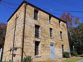
The old Coosa County Jail is a former jail in Rockford, Alabama. It is the oldest extant stone jail in Alabama.

The Music City Center is a convention complex located in downtown Nashville, Tennessee, United States. It opened in May 2013.
Grover Center was originally built to be the home for the Ohio Bobcats men's basketball team. The first men's basketball game in the arena featured the Ohio Bobcats hosting the previous years national champion Ohio State Buckeyes on December 1, 1960 to a sold out crowd. The Ohio Bobcats basketball team only called the Grover Center home from 1960–68 after the much larger Convocation Center opened up December 3, 1968.

The Ranger Bridge between Wells River, Vermont and Woodsville, New Hampshire, is a three-hinged steel arch truss bridge over the Connecticut River. It was built in 1923 to replace a 1917 bridge. This is the oldest steel arch bridge over the Connecticut River.
The Seneca Road Company was formed to improve the main road running west from Utica, New York, the Genesee Road, from Utica to Canandaigua and operate it as a toll road or turnpike. The road was originally laid out in 1794 from Baggs Square in downtown Utica at the ford of the Mohawk River and followed the Indian trail past Syracuse to Canandaigua. Some accounts say it went to Geneva and Avon originally. There was no City of Syracuse then. The road became known as the Seneca Turnpike, which was 157 miles (253 km) long and, at the time, the longest toll road in the state.
