Related Research Articles

The Bay of Quinte is a long, narrow bay shaped like the letter "Z" on the northern shore of Lake Ontario in the province of Ontario, Canada. It is just west of the head of the Saint Lawrence River that drains the Great Lakes into the Gulf of Saint Lawrence. It is located about 200 kilometres (120 mi) east of Toronto and 350 kilometres (220 mi) west of Montreal.

The Gulf of St. Lawrence fringes the shores of the provinces of Quebec, New Brunswick, Nova Scotia, Prince Edward Island, Newfoundland and Labrador, in Canada, plus the islands Saint-Pierre and Miquelon, possessions of France, in North America.

San Pablo Bay is a tidal estuary that forms the northern extension of the San Francisco Bay in the East Bay and North Bay regions of the San Francisco Bay Area in northern California.

Machias Seal Island is an island in disputed water between the Gulf of Maine and the Bay of Fundy, about 8.6 nmi (16 km) southeast from Cutler, Maine, and 10 nmi (19 km) southwest of Grand Manan Island, New Brunswick. Sovereignty of the island is disputed by the United States and Canada. The Canadian Coast Guard continues to staff a lighthouse on the island; the first lighthouse was constructed there in 1832.
Thunder Bay is a bay in the U.S. state of Michigan on Lake Huron. The bay extends from North Point at 45°01′19″N83°15′58″W to South Point at 44°53′00″N83°18′51″W.

Cobscook Bay is located in Washington County in the state of Maine. It opens into Passamaquoddy Bay, within the Bay of Fundy. Cobscook Bay is immediately south of the island city of Eastport, the main island of which straddles the two bays. In the 1930s, Cobscook Bay was part of the aborted Passamaquoddy Bay Tidal Power Project to generate electricity from its large tidal range.

The Annapolis Basin is a sub-basin of the Bay of Fundy, located on the bay's southeastern shores, along the northwestern shore of Nova Scotia and at the western end of the Annapolis Valley.

The Door Peninsula is a peninsula in eastern Wisconsin, separating the southern part of the Green Bay from Lake Michigan. The peninsula includes northern Kewaunee County, northeastern Brown County, and the mainland portion of Door County. It is on the western side of the Niagara Escarpment. Well known for its cherry and apple orchards, the Door Peninsula is a popular tourism destination. With the 1881 completion of the Sturgeon Bay Ship Canal, the northern half of the peninsula became an island.

Driftless Area National Wildlife Refuge is a United States National Wildlife Refuge in northeastern Iowa, southwestern Wisconsin and northwestern Illinois. It is a collection of non-contiguous parcels in the vicinity of the Upper Mississippi River National Wildlife and Fish Refuge.
Pine River Breaks Provincial Park is a provincial park in British Columbia, Canada in the Peace River Lowland between the communities of East Pine and Chetwynd.
Pleasant Bay is a bay in Washington County, Maine. It contains three rivers: Narraguagus River, Pleasant River, and Harrington River. Mudflats are present in coastal areas of the bay. The bay functions as a staging area for migratory birds as well as migratory fish like Atlantic Salmon. Some other species found in the area include: bald eagles, peregrine falcons, and crowberry blue butterflies.
Harrington Bay is a bay in Washington County, Maine.
Narraguagus Bay is a bay in Washington County, Maine.
Chandler Bay is a bay in Jonesport, Maine.
Moose Island is an island in Eastport, Maine, located at the entrance to Cobscook Bay from Passamaquoddy Bay in the Bay of Fundy. Shackford Head State Park is on Moose Island.
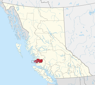
The Wuikinuxv Nation, also known as the Oweekeno Nation, is a First Nations band government whose traditional territory is the shores of Rivers Inlet and Owikeno Lake in the Central Coast region of the Canadian province of British Columbia, in the area south of Bella Bella and north of Queen Charlotte Strait. The Wuikinuxv people a.k.a. the Oweekeno people reside in the area of Rivers Inlet and Owikeno Lake, primarily at a village on the Wannock River. Substantial numbers of Wuikinuxv also reside away from the traditional territory in Port Hardy on Vancouver Island and in larger BC communities such as Campbell River, Vancouver and Victoria. Approximately 80 people reside at the village while overall membership was 283 in 2006, 194 of whom lived off-reserve.

Minesing Wetlands, previously known as Minesing Swamp, is a Ramsar boreal wetland in central Ontario, Canada stretching from the western periphery of Barrie to Georgian Bay. It was identified and classified through the International Biological Program. It is "the largest and best example of fen bog in southern Ontario", one of the "most diverse undisturbed wetland tracts in Canada" and is a provincially significant Area of Natural and Scientific Interest. The term minesing is of Ojibwe origin and means "island", referring to an island located within Lake Edenvale, which encompassed the present-day wetlands and surrounding areas.

The second HMS Essington (K353), and the first ship of the name to see service, was a British Captain-class frigate of the Royal Navy in commission during World War II. Originally constructed as a United States Navy Buckley-class destroyer escort, she served in the Royal Navy from 1943 to 1945.

The Crown Wetlands lie on Little Cayman, one of the Cayman Islands, a British Overseas Territory in the Caribbean Sea. Collectively they form one of the territory's Important Bird Areas (IBAs).
Cockmi Indian Reserve No. 3, officially Cockmi 3, is one of the three Indian reserves of the Wuikinuxv Nation band government located on the west tip of Walbran Island, which is near Darby Channel in the area of Fitz Hugh Sound on the Central Coast of British Columbia, Canada. The other two Wuikinuxv reserves are Kiltala Indian Reserve No. 2 on the Kilbella River near Kilbella Bay and Katit Indian Reserve No. 1, up the Wannock River from the community of Rivers Inlet at the entrance to Owikeno Lake.
References
- ↑ Purple, Adam (Summer 2012). "Dream Islands". Portland Magazine . Retrieved 2 June 2014.
44°31′20″N67°41′00″W / 44.52222°N 67.68333°W
| | This Maine state location article is a stub. You can help Wikipedia by expanding it. |