Harraseeket River

Last updated • 3 min readFrom Wikipedia, The Free Encyclopedia
Harraseeket River
Harraseeket River South Freeport.jpg
The Harraseeket River in South Freeport, Maine
Location
Country United States
Physical characteristics
Source 
  location Maine

The Harraseeket River is a 3.2-mile-long (5.1 km) [1] tidal river in the town of Freeport within the U.S. state of Maine. It forms a northern arm of Casco Bay.

Contents

Several smaller streams flow into the Harraseeket that have their headwaters in Freeport and Brunswick, to include Frost Gully Brook and Kelsey Brook. [2] The Harraseeket embayment [3] joins Casco Bay between Moore Point on its eastern shore, and Stockbridge Point on its western shore, with a small island called Pound of Tea dividing the channel. [4]

The Maine Department of Inland Fisheries & Wildlife includes the Harraseeket in the designated Maquoit and Middle Bay Focus Area of Statewide Ecological Significance that extends from Harpswell Neck to the Royal River in Yarmouth, recognizing a diverse habitat for fish and wildlife including tidal marshes, eelgrass beds and mudflats. [5]

Protected lands open to the public along the Harraseeket include Wolfe's Neck Woods State Park, [6] the Mast Landing Audubon Sanctuary [7] and Winslow Memorial Park. [8]

Ecology

The Harraseeket River supports a range of wildlife and tidal organisms, to include ducks like Barrow's goldeneye, common goldeneye, [9] northern pintail and lesser scaup; [10] fish like Atlantic mackerel and rainbow smelt; [11] and shellfish like blue mussels, [12] soft-shell clams and green crabs. [13] Herring gulls and great black-backed gulls are a constant in the Harraseeket River basin, along with cormorants. [14]

In 2023, three dams were removed from Frost Gully Brook which flows into the Harraseeket River, improving the habitat there for brook trout. [15]

The municipal Freeport Sewer District operates a secondary wastewater treatment plant licensed to discharge an average of 750,000 gallons daily into the Harraseeket River via an outfall pipe. Flows are monitored seasonally for Enterococci bacteria and under the parameters of the National Shellfish Sanitation Program. [16]

Marine economy

Multiple marinas and boatyards operate in the Harraseeket with sailboats and power boats moored in an extensive anchorage in the lower reaches of the estuary. [17] Other enterprises include commercial lobster boats, an island ferry, tour boats and other working boats. [18]

The town of Freeport maintains a public dock on the west bank of the Harraseeket, and employs a harbor master and shellfish warden. [19]

History

Prior to the arrival of European settlers, Abenaki peoples who were allied with the larger Wabanaki Confederacy lived in the Casco Bay region. Some researchers have identified the Almouchiquois or Aucocisco as the area's dominant group centered on the Presumpscot River west of the Harraseeket, [20] while another group called the Pejebscot were located along the Androscoggin River east of the Harraseeket. [21]

The earliest colonial settlements along the Harraseeket were linked to farming or harvesting pine trees for ship masts for the Royal Navy, with those logging efforts centered initially on the Piscataqua River. [21] Trees marked for Royal Navy use were marked with a "broad arrow" symbol, with a penalty of 100 pounds sterling to be levied on anyone who cut down any of those trees without permission, but with evidence that plenty of local residents flouted the rule. Mast Landing, situated in the upper navigable reaches of the Harraseeket, became a loading point for the timber, and in time shipbuilding emerged as a major industry on the Harraseeket. [22]

During the 17th and early 18th century, a number of Maine farmers turned to shipbuilding as a way to capitalize on surplus timber they cleared to grow crops, typically forming syndicates to share ownership and any profits from cargoes. While some vessels were built on farm properties and then launched there or hauled overland to waterways, small shipyards began opening along rivers and harbors that attracted and then groomed over succeeding generations a homegrown industry of shipwrights, tradesmen and laborers under the direction of "master builders". [23]

Born in 1753 in Weymouth, Massachusetts, by 1777 Seward Porter had built a homestead near Mast Landing. In 1782, Porter commenced shipbuilding at what would become known as Porter's Landing. [24]

In the 1830s, Rufus Soule began leasing space at Porter's Landing for a shipyard that would launch more than 100 vessels. Others would follow downstream along the Harraseeket River, to include shipyards under the names Briggs & Cushing, Talbot, Bliss and Soule Brothers. [25]

In 1974, the Harraseeket Historic District was added to the National Register of Historic Places, including Wolfe's Neck, Mast Landing, Porter's Landing and the village of South Freeport. [26]

See also

Related Research Articles

<span class="mw-page-title-main">Cumberland County, Maine</span> County in Maine, United States

Cumberland County is a county in the U.S. state of Maine. As of the 2020 census, the population was 303,069, making it the most populous county in Maine. Its county seat is Portland. Cumberland County was founded in 1760 from a portion of York County, Province of Massachusetts Bay, and named for William, Duke of Cumberland, a son of King George II. Cumberland County has the deepest and second-largest body of water in the state, Sebago Lake, which supplies tap water to most of the county. The county is the state's economic and industrial center, having the resources of the Port of Portland, the Maine Mall, and having corporate headquarters of major companies such as onsemi, IDEXX Laboratories, Unum, and TD Bank. Cumberland County is part of the Portland–South Portland, ME Metropolitan Statistical Area.

<span class="mw-page-title-main">Falmouth, Maine</span> Town in Maine, United States

Falmouth is a town in Cumberland County, Maine, United States. The population was 12,444 at the 2020 census. It is part of the Portland–South Portland–Biddeford, Maine metropolitan statistical area.

<span class="mw-page-title-main">Casco Bay</span> Inlet of the Gulf of Maine, United States

Casco Bay is an inlet of the Gulf of Maine on the southern coast of Maine, New England, United States. Its easternmost approach is Cape Small and its westernmost approach is Two Lights in Cape Elizabeth. The city of Portland sits along its southern edge and the Port of Portland lies within.

<span class="mw-page-title-main">Fore River (Maine)</span> Estuary in Maine, United States

The Fore River is a short horn-shaped estuary, approximately 5.7 miles (9.2 km) long, separating Portland and South Portland in Maine in the United States. Many of the port facilities of the Portland harbor are along the estuary, which is formed just southwest of Portland by the confluence of several creeks. The estuary was initially known as Levett's River, so named by the first English settler of the Casco Bay region, Capt. Christopher Levett. But shortly afterwards, the estuary came to have the name by which it is known today.

<span class="mw-page-title-main">Saco Bay</span> Bay off of Maine, US

Saco Bay is a small curved embayment of the Gulf of Maine on the Atlantic coast of Maine in the United States.

<span class="mw-page-title-main">Casco Bay Lines</span> Publicly run transportation company in Maine, US

Casco Bay Lines is a publicly run transportation company that services the residents of the islands of Casco Bay, Maine. The seven islands are Peaks Island, Little Diamond Island, Great Diamond Island, Diamond Cove, Long Island, Chebeague Island and Cliff Island.

<span class="mw-page-title-main">Presumpscot River</span> River in Maine, United States

The Presumpscot River is a 25.8-mile-long (41.5 km) river located in Cumberland County, Maine, United States. It is the main outlet of Sebago Lake. The river provided an early transportation corridor with reliable water power for industrial development of the city of Westbrook and the village of South Windham.

The Little Androscoggin River is a 51.4-mile-long (82.7 km) river in Maine. It flows from Bryant Pond in Woodstock to its confluence with the Androscoggin River in Auburn. The Androscoggin flows into Merrymeeting Bay in the Kennebec River estuary.

<span class="mw-page-title-main">Little River (Casco Bay)</span> River in the United States

Little River is a 4.1-mile-long (6.6 km) tributary of Casco Bay in Maine, United States.

<span class="mw-page-title-main">Wolfe's Neck Woods State Park</span> State park in Cumberland County, Maine

Wolfe's Neck Woods State Park is a public recreation area located on Casco Bay on the southeastern side of Freeport, Maine. The state park occupies 244 acres (99 ha) on a narrow peninsula, Wolfe's Neck, that runs between Casco Bay and the Harraseeket River. It includes white pine and hemlock forests, salt marsh estuary, and rocky shore. The park is managed by the Maine Department of Agriculture, Conservation and Forestry.

<span class="mw-page-title-main">Capt. Greenfield Pote House</span> Historic house in Maine, United States

The Captain Greenfield Pote House is an historic house located on Wolfe's Neck Road in Freeport, Maine, United States. Built c. 1750 and supposedly moved to this location in 1765, it is Freeport's oldest surviving building. It was listed on the National Register of Historic Places in 1970, and is part of the Harraseeket Historic District. The property is owned by the Wolfe's Neck Center for Agriculture and the Environment.

<span class="mw-page-title-main">Freeport, Maine</span> Town in Maine, United States

Freeport is a town in Cumberland County, Maine, United States. Freeport is included in the Lewiston-Auburn, Maine metropolitan New England City and town area. The population was 8,737 at the 2020 census. Once home to a prominent shipbuilding industry, timber operations, and farming, it is now known for its numerous outlet stores; Freeport is home to L.L. Bean, Wolfe's Neck Woods State Park, and the Desert of Maine.

<span class="mw-page-title-main">Harraseeket Historic District</span> Historic district in Maine, United States

The Harraseeket Historic District encompasses some of the oldest maritime village areas of the town of Freeport, Maine. It includes properties along both banks of the tidal Harraseeket River, from the Mast Landing area in the north to Wolf Neck and the villages of Porter's Landing and South Freeport on the west bank of the river. The district was listed on the National Register of Historic Places in 1974.

<span class="mw-page-title-main">Freeport Main Street Historic District</span> Historic district in Maine, United States

The Freeport Main Street Historic District encompasses a 1-2 block area of Main Street in Freeport, Maine. It extends from Grove and Holbrook Streets in the south to Mill and Nathan Nye Streets in the north, just south of the L. L. Bean complex. The district, listed on the National Register of Historic Places in 1977, encompasses a well-preserved remnant of Freeport's 19th century town center.

<span class="mw-page-title-main">Pettengill House and Farm</span> Historic house in Maine, United States

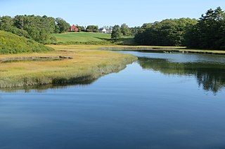
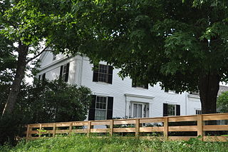
The Pettengill House and Farm is a historic conservation property in Freeport, Maine, United States. Now owned by the Freeport Historical Society, this farm was in active use from at least 1831 until 1960. More than 140 acres (57 ha) of its original 180 acres (73 ha) have been preserved, as has the c. 1800 saltbox farmhouse. The property was listed on the National Register of Historic Places in 1970, and is part of the 1974 Harraseeket Historic District. The farm is located at the southern end of Pettengill Road in Freeport's Mast Landing area. The house faces south, looking down the Harraseeket River. The property's trails are open to the public daily from dawn to dusk.

Rufus Soule was a boat builder in Maine and served for several years in the state legislature.

<span class="mw-page-title-main">Porter's Landing</span> Community in Maine, United States

Porter's Landing is a community in Freeport, Maine, United States. Located above the Harraseeket River, around 1 mile (1.6 km) south of Freeport town center, it was the port for Freeport prior to the arrival of the railroad. It was also known for its shipyard, along with its salt works, brickyard and a crab-meat factory. Porter's Landing is part of Harraseeket Historic District, which is listed on the National Register of Historic Places.

<span class="mw-page-title-main">Maquoit Bay</span> Bay in Maine, United States

Maquoit Bay is a bay in Cumberland County, Maine, in the northern part of Casco Bay. It is located between South Freeport and Mere Point, Brunswick, and is a Focus Area of Statewide Ecological Significance and one of the state's Important Bird Areas.

<span class="mw-page-title-main">Winslow Memorial Park</span> Public park in Freeport, Maine, U.S.

Winslow Memorial Park is a coastal park and campground in Freeport, Maine, United States. Set in 90 acres (0.14 sq mi), it is located near the southern end of the Harraseeket River, near its mouth with Casco Bay, at the eastern end of Staples Point Road. The northern side of the park looks out over Staples Cove.

<span class="mw-page-title-main">Maine Land Trust Network</span>

The Maine Land Trust Network promotes discussion among the eighty land trusts in Maine, United States. It was established in 1995.

References

  1. U.S. Geological Survey. National Hydrography Dataset high-resolution flowline data. The National Map, accessed June 30, 2011
  2. "Inner Bay". Casco Bay Estuary Partnership. Retrieved 17 August 2024.
  3. Grady, Meryl (2019). "WJ Growing Area" (PDF). WJ Sanitary Survey 2019: 4. Retrieved 19 August 2024.
  4. "NOAA Chart - 13290" (PDF). NOAA Chart - 13290_Public. National Oceanic and Atmospheric Administration. Retrieved 17 August 2024.
  5. "Maquoit and Middle Bay" (PDF). Focus Areas of Statewide Ecological Significance. Maine Department of Agriculture, Conservation & Forestry. Retrieved 17 August 2024.
  6. "Wolfe's Neck Woods State Park". Parks & Natural Attractions. Maine Office of Tourism. Retrieved 17 August 2024.
  7. "Mast Landing Audubon Sanctuary". Mast Landing Audubon Sanctuary. Maine Audubon. Retrieved 17 August 2024.
  8. "Winslow Park". Winslow Park. Freeport Conservation Trust. Retrieved 17 August 2024.
  9. Gallo, Susan; Hodgman, Thomas P.; Camuso, Judy. "Important Bird Areas of Maine" (PDF). Maine Audubon. Retrieved 20 August 2024.
  10. Lovitch, Derek. "Recent Highlights, 2/24– 3/1/2024". Maine Birding Fieldnotes. Retrieved 19 August 2024.
  11. "Fourth North American Workshop on Rainbow Smelt: Extended Abstract Proceedings" (PDF). North American Workshop on Rainbow Smelt: 15. July 2012. Retrieved 20 August 2024.
  12. "Human Exposure to Toxic Chemicals Through Subsistence Shellfishing in Casco Bay" (PDF). cascobayestuary.org. Casco Bay Estuary Project. Retrieved 19 August 2024.
  13. "Investigation Into The Cause Of The Clam Decline: 2015". Downeast Institute. Retrieved 19 August 2024.
  14. Wilde, Dana (2022). "The 'Undeclared War' on the Reviled Cormorant". Island Journal. Retrieved 20 August 2024.
  15. "Program Highlights" (PDF). Coastal Program. U.S. Fish & Wildlife Service. Retrieved 19 August 2024.
  16. "Proposed Draft MEPDES Permit Renewal" (PDF). EPA. State of Maine Department of Environmental Protection. Retrieved 19 August 2024.
  17. United States Coast Pilot 1 (PDF). National Oceanic and Atmospheric Administration. 11 August 2024. p. 281. Retrieved 20 August 2024.
  18. "Coastal Waters Ordinance". Town of Freeport, Maine. Retrieved 20 August 2024.
  19. "Harbor Master". FreeportMaine.com. Town of Freeport, Maine. Retrieved 20 August 2024.
  20. "About Falmouth - The Almouchiquois". About Falmouth - The Almouchiquois. The Falmouth Historical Society. Retrieved 17 August 2024.
  21. 1 2 Thurston, Florence G.; Cross, Harmon S. (1940). Three Centuries of Freeport, Maine. Portland, Maine: The Southworth-Anthoensen Press. Retrieved 17 August 2024.
  22. Hurd, Holly (2016). "The King of England's Claim in Freeport, Maine" (PDF). The Dash (Winter 2016): 1, 3. Retrieved 17 August 2024.
  23. Fairburn, William Armstrong (1955). Merchant Sail, Volume V. Lovell, Maine: Fairburn Marine Educational Foundation. pp. 3230–3231. Retrieved 18 August 2024.
  24. "The Story of the Dash". Freeport History. Freeport Historical Society. Retrieved 18 August 2024.
  25. Hurd, Holly. "Strouts Point: An Active Waterfront for More Than Two Centuries" (PDF). The Dash - Freeport Historical Society (Summer 2017): 1, 7–8. Retrieved 18 August 2024.
  26. "Harraseeket Historic District FAQs". Harraseeket Historic District. Freeport Historical Society. Retrieved 20 August 2024.

43°48′17″N70°06′01″W / 43.80480°N 70.10033°W / 43.80480; -70.10033