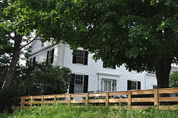
The Main Street Historic District is a small residential historic district south of the downtown area of Auburn, Maine. The fourteen houses in the district represent a cross-section of residential development during Auburn's growth between about 1825 and 1925. The district extends along Main Street, from Drummond Street south just past Elm Street, and includes a few houses on Elm and Vine Streets. The district was added to the National Register of Historic Places in 1989.

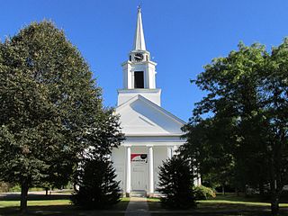
The West Durham Methodist Church is an historic Methodist church at 23 Runaround Pond Road in West Durham, Maine. Built in the early 19th century and significantly restyled in 1867, it is a fine example of Greek Revival architecture with added Italianate features. The congregation for which it was built grew out of a Methodist revival meeting held at the site in 1804, and was one of the first Methodist congregations in the state. The building was listed on the National Register of Historic Places in 2003. It is presently unused.

The South Britain Historic District encompasses the core of the unincorporated village of South Britain in Southbury, Connecticut, United States. The village arose in the 18th century as an industrial center serving the surrounding agricultural community, powered by the Pomperaug River, and rivalled the town center of Southbury in importance. The district was listed on the National Register of Historic Places in 1987.

The Hotchkissville Historic District is a historic district in the town of Woodbury, Connecticut, United States that was listed on the National Register of Historic Places in 1995. The district encompasses most of the historic village of Hotchkissville, which is centered at the junction of Washington and Weekeepeemee roads. The village began as a dispersed rural agricultural community, but developed in the 19th century with the arrival of industry, primarily the manufacture of textiles. Despite this, the village has retained a significantly rural character, and includes a broad cross-section of 18th- and 19th-century architectural styles.
The Cherryfield Historic District encompasses the historic village center of Cherryfield, Maine. This area is distinctive for its collection of high-quality 19th century architecture, which is unique in rural contexts in the state. The district was listed on the National Register of Historic Places in 1990.
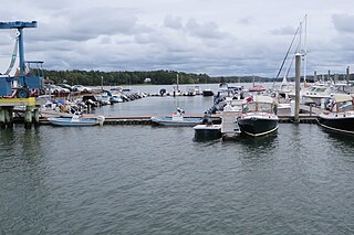
The Harraseeket River is a 3.2-mile-long (5.1 km) tidal river in the town of Freeport within the U.S. state of Maine. It forms a northern arm of Casco Bay.

The Saco Historic District encompasses the historic commercial and residential centers of Saco, Maine. Covering more than 100 acres (40 ha) of central Saco, it includes houses from the 18th through 20th centuries, and the main business district along Main Street. It was added to the National Register of Historic Places in 1998.
Stroudwater Historic District is a historic district in the Stroudwater neighborhood of Portland, Maine. The district encompasses an important early village in the Portland area, significant as a shipbuilding and mill site established by Thomas Westbrook in 1727. The district was added to the National Register of Historic Places in 1973.

The Captain Greenfield Pote House is an historic house located on Wolfe's Neck Road in Freeport, Maine, United States. Built c. 1750 and supposedly moved to this location in 1765, it is Freeport's oldest surviving building. It was listed on the National Register of Historic Places in 1970, and is part of the Harraseeket Historic District. The property is owned by the Wolfe's Neck Center for Agriculture and the Environment.

Freeport is a town in Cumberland County, Maine, United States. Freeport is included in the Lewiston-Auburn, Maine metropolitan New England City and town area. The population was 8,737 at the 2020 census. Once home to a prominent shipbuilding industry, timber operations, and farming, it is now known for its numerous outlet stores; Freeport is home to L.L. Bean, Wolfe's Neck Woods State Park, and the Desert of Maine.

The Old County Road South Historic District is a rural historic district encompassing a well-preserved collection of 18th and early 19th-century rural farm properties in Francestown, New Hampshire. It includes nine houses, whose construction dates from 1774 to 1806, and the only two extant 18th-century saltbox-style houses in the town. There is also a Cape-style house built using the relatively rare vertical-plank method of framing, and there are several surviving 19th-century barns. The district covers 500 acres (200 ha) along all or part of Old County Road South, Pratt (Clark) Road, and Birdsall Road. The district was listed on the National Register of Historic Places in 1980.

The Town Center Historic District encompasses the historic village center of South Hampton, New Hampshire. Centered around the Barnard Green, the town common, on New Hampshire Route 107A, it includes architectural reminders of the town's growth and change over time. The district was listed on the National Register of Historic Places in 1983.

The Freeport Main Street Historic District encompasses a 1-2 block area of Main Street in Freeport, Maine. It extends from Grove and Holbrook Streets in the south to Mill and Nathan Nye Streets in the north, just south of the L. L. Bean complex. The district, listed on the National Register of Historic Places in 1977, encompasses a well-preserved remnant of Freeport's 19th century town center.

The Broad Street Historic District encompasses a significant portion of the historic center of Bethel, Maine. Broad Street dates to the early days of Bethel's settlement in the early 19th century, and its town common was a gift from the first settler of the area. As originally listed on the National Register of Historic Places in 1977, the district included the common and a section of Broad Street between Main Street and Paradise Hill Road. This was expanded in 1990 along Church Street to encompass historic homes and a portion of the Gould Academy campus.
The Main Street Historic District of Fryeburg, Maine, encompasses the growth of the town's principal village between about 1800 and 1935. It extends along Main Street, from Woodland Street in the north to Portland Street (SR 5 and Maine State Route 113) in the south, and includes forty primary buildings on 55 acres (22 ha). The district was listed on the National Register of Historic Places in 1991.

The Lower Alewive Historic District encompasses a rural agricultural landscape in northwestern Kennebunk, Maine. It includes four farm properties, all originally laid out in the 1750s, between the Kennebunk River to the north, and a street now variously named Russell Farm Road, Emmons Road Extension, and Winnow Hill Lane to the south. The district was listed on the National Register of Historic Places in 1994.
The Dennysville Historic District encompasses the historic town center of Dennysville, Maine. Located near the southern end of the large rural community, its architecture covers more than 100 years of community history, from the early 19th to early 20th centuries. The district extends along Main Street between Maine State Route 86 and Bunker Hill Road, on the west bank of the Dennys River. It was listed on the National Register of Historic Places in 1982.

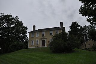
The Pettengill House and Farm is a historic conservation property in Freeport, Maine, United States. Now owned by the Freeport Historical Society, this farm was in active use from at least 1831 until 1960. More than 140 acres (57 ha) of its original 180 acres (73 ha) have been preserved, as has the c. 1800 saltbox farmhouse. The property was listed on the National Register of Historic Places in 1970, and is part of the 1974 Harraseeket Historic District. The farm is located at the southern end of Pettengill Road in Freeport's Mast Landing area. The house faces south, looking down the Harraseeket River. The property's trails are open to the public daily from dawn to dusk.
Rufus Soule was a boat builder in Maine and served for several years in the state legislature.

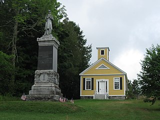
Porter's Landing is a community in Freeport, Maine, United States. Located above the Harraseeket River, around 1 mile (1.6 km) south of Freeport town center, it was the port for Freeport prior to the arrival of the railroad. It was also known for its shipyard, along with its salt works, brickyard and a crab-meat factory. Porter's Landing is part of Harraseeket Historic District, which is listed on the National Register of Historic Places.